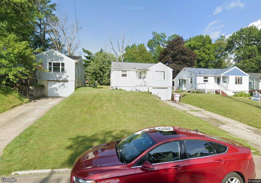
304 Poplar St Mansfield, OH 44903
Estimated Value: $47,000 - $112,000
2
Beds
1
Bath
664
Sq Ft
$116/Sq Ft
Est. Value
About This Home
This home is located at 304 Poplar St, Mansfield, OH 44903 and is currently estimated at $77,274, approximately $116 per square foot. 304 Poplar St is a home located in Richland County with nearby schools including St. Peter's High School/Junior High, Discovery School, and St. Peter's Elementary/Montessori School.
Ownership History
Date
Name
Owned For
Owner Type
Purchase Details
Closed on
Jun 7, 2013
Sold by
Atkeson Stephanie D and Atkeson Stephanie E
Bought by
Atkeson Michael D
Current Estimated Value
Purchase Details
Closed on
Mar 27, 2008
Sold by
Sopramco Cv6 Llc
Bought by
Atkeson Michael D and Atkeson Stephanie D
Purchase Details
Closed on
Feb 20, 2008
Sold by
Basham Michael C and Basham Christine R
Bought by
Sopramco Cv6 Llc
Purchase Details
Closed on
Jan 2, 2004
Sold by
Basham Michael C
Bought by
Basham Christine R
Purchase Details
Closed on
May 29, 2001
Sold by
Bankers Trst Co Ca Trust
Bought by
Basham Michael C and Basham Christine
Purchase Details
Closed on
Apr 30, 2001
Sold by
Shrf Corey Welch Pr
Bought by
Bankers Trust Co Ca Na
Create a Home Valuation Report for This Property
The Home Valuation Report is an in-depth analysis detailing your home's value as well as a comparison with similar homes in the area
Home Values in the Area
Average Home Value in this Area
Purchase History
| Date | Buyer | Sale Price | Title Company |
|---|---|---|---|
| Atkeson Michael D | -- | Versatitle | |
| Atkeson Michael D | $15,100 | None Available | |
| Sopramco Cv6 Llc | $16,000 | None Available | |
| Basham Christine R | -- | -- | |
| Basham Michael C | $28,900 | -- | |
| Bankers Trust Co Ca Na | $34,516 | -- |
Source: Public Records
Tax History Compared to Growth
Tax History
| Year | Tax Paid | Tax Assessment Tax Assessment Total Assessment is a certain percentage of the fair market value that is determined by local assessors to be the total taxable value of land and additions on the property. | Land | Improvement |
|---|---|---|---|---|
| 2024 | $591 | $12,350 | $2,960 | $9,390 |
| 2023 | $591 | $12,350 | $2,960 | $9,390 |
| 2022 | $489 | $8,560 | $2,400 | $6,160 |
| 2021 | $492 | $8,560 | $2,400 | $6,160 |
| 2020 | $504 | $8,560 | $2,400 | $6,160 |
| 2019 | $558 | $8,560 | $2,400 | $6,160 |
| 2018 | $551 | $8,560 | $2,400 | $6,160 |
| 2017 | $536 | $8,560 | $2,400 | $6,160 |
| 2016 | $433 | $6,700 | $3,200 | $3,500 |
| 2015 | $413 | $6,700 | $3,200 | $3,500 |
| 2014 | $408 | $6,700 | $3,200 | $3,500 |
| 2012 | $164 | $7,040 | $3,360 | $3,680 |
Source: Public Records
Map
Nearby Homes
- 257 Wood St
- 538 Broadview Ave
- 114 Vennum Ave
- 118 Lind Ave
- 126 Dawson Ave
- 133 Stewart Ave S
- 119 Carpenter Rd
- 88 Sherman Ave
- 76 Bartley Ave
- 135 Wood St
- 353 Sturges Ave
- 679 Coleman Rd
- 505 Wood St
- 0 Cline Ave Hedeen Abbeyfeale Unit 9066362
- 37 Baldwin Ave
- 71 Glenwood Blvd
- 709 Coleman Rd
- 118 Parkwood Blvd
- 131 Sturges Ave
- 120 Grover St
- 298 Poplar St
- 308 Poplar St
- 294 Poplar St
- 312 Poplar St
- 312 -314 Poplar St
- 290 Poplar St
- 318 Poplar St
- 317 Bartley Ave
- 307 Bartley Ave
- 313 Bartley Ave
- 322 Poplar St
- 287 Bartley Ave
- 297 Bartley Ave
- 305 Poplar St
- 299 Poplar St
- 309 Poplar St
- 295 Poplar St
- 321 Bartley Ave
- 427 Parkview St Unit 429
- 421 Parkview St Unit 423