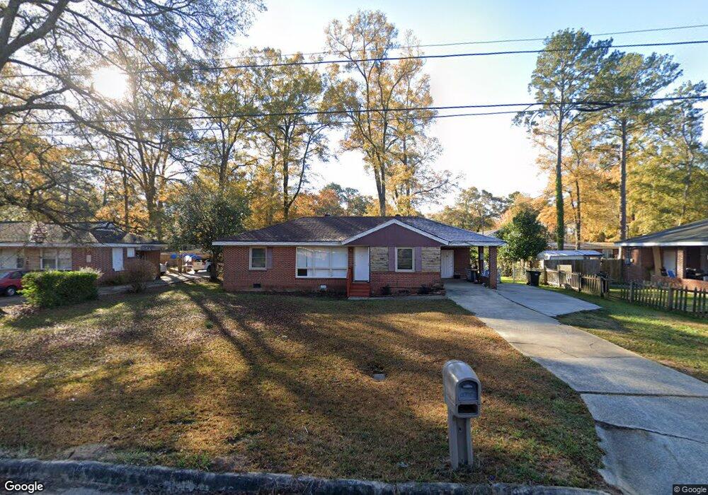
3042 Ormand Dr Columbus, GA 31903
South Columbus NeighborhoodEstimated Value: $74,000 - $90,000
3
Beds
2
Baths
1,170
Sq Ft
$68/Sq Ft
Est. Value
About This Home
This home is located at 3042 Ormand Dr, Columbus, GA 31903 and is currently estimated at $80,025, approximately $68 per square foot. 3042 Ormand Dr is a home located in Muscogee County with nearby schools including South Columbus Elementary School, Eddy Middle School, and Spencer High School.
Ownership History
Date
Name
Owned For
Owner Type
Purchase Details
Closed on
Nov 18, 2018
Sold by
Black Azlynne C
Bought by
Colobong Reynaldo D and Colobong Felicisima O
Current Estimated Value
Purchase Details
Closed on
Apr 21, 2017
Bought by
Black Azlynne C
Purchase Details
Closed on
Mar 7, 2017
Bought by
Federal National Mtg Associati
Purchase Details
Closed on
Dec 6, 2012
Sold by
Ledbetter Terrance
Bought by
Ledbetter Tysha L
Create a Home Valuation Report for This Property
The Home Valuation Report is an in-depth analysis detailing your home's value as well as a comparison with similar homes in the area
Home Values in the Area
Average Home Value in this Area
Purchase History
| Date | Buyer | Sale Price | Title Company |
|---|---|---|---|
| Colobong Reynaldo D | $38,000 | -- | |
| Black Azlynne C | $38,000 | -- | |
| Federal National Mtg Associati | $32,500 | -- | |
| Wells Fargo Bank | $32,500 | -- | |
| Ledbetter Tysha L | -- | -- |
Source: Public Records
Tax History
| Year | Tax Paid | Tax Assessment Tax Assessment Total Assessment is a certain percentage of the fair market value that is determined by local assessors to be the total taxable value of land and additions on the property. | Land | Improvement |
|---|---|---|---|---|
| 2025 | $1,110 | $28,352 | $3,512 | $24,840 |
| 2024 | $1,110 | $28,352 | $3,512 | $24,840 |
| 2023 | $1,117 | $28,352 | $3,512 | $24,840 |
| 2022 | $1,020 | $24,976 | $3,512 | $21,464 |
| 2021 | $939 | $23,000 | $3,512 | $19,488 |
| 2020 | $939 | $23,000 | $3,512 | $19,488 |
| 2019 | $623 | $15,200 | $2,720 | $12,480 |
| 2018 | $623 | $15,200 | $2,640 | $12,560 |
| 2017 | $981 | $23,860 | $4,388 | $19,472 |
| 2016 | $1,192 | $28,885 | $3,944 | $24,941 |
| 2015 | $645 | $28,885 | $3,944 | $24,941 |
| 2014 | $647 | $28,885 | $3,944 | $24,941 |
| 2013 | -- | $28,885 | $3,944 | $24,941 |
Source: Public Records
Map
Nearby Homes
- 2102 Somerset Ave
- 2058 Somerset Ave
- 3015 Hendrix St
- 3018 Plantation Rd
- 2203 Simmons Ave
- 3048 Knox St
- 3233 Hendrix St
- 2241 Bruce Ave
- 1818 Somerset Ave
- 2333 Bruce Ave
- 3044 Wise St
- 2343 Manning Ave
- 3063 Meade St
- 2404 Bruce Ave
- 2425 Howe Ave
- 3433 Marathon Dr
- 2309 Ginny Ave
- 2450 Cornell Ave
- 2846 Walker St
- 2720 Wise St
- 3046 Ormand Dr
- 3038 Ormand Dr
- 3039 Colonial Dr
- 3045 Colonial Dr
- 3050 Ormand Dr
- 3034 Ormand Dr
- 3035 Colonial Dr
- 3041 Ormand Dr
- 3045 Ormand Dr
- 3037 Ormand Dr
- 3049 Ormand Dr
- 3030 Ormand Dr
- 3031 Colonial Dr
- 3031 Ormand Dr
- 3053 Ormand Dr
- 2120 Rosemary Ln
- 2114 Rosemary Ln
- 2126 Rosemary Ln
- 3042 Colonial Dr
- 3029 Ormand Dr
Your Personal Tour Guide
Ask me questions while you tour the home.