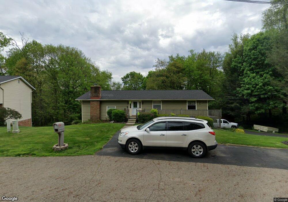
3044 Broad Vista St NW Uniontown, OH 44685
Estimated Value: $250,801 - $282,000
3
Beds
3
Baths
1,528
Sq Ft
$175/Sq Ft
Est. Value
About This Home
This home is located at 3044 Broad Vista St NW, Uniontown, OH 44685 and is currently estimated at $267,950, approximately $175 per square foot. 3044 Broad Vista St NW is a home located in Stark County with nearby schools including Lake Middle/High School and Lake Center Christian School.
Ownership History
Date
Name
Owned For
Owner Type
Purchase Details
Closed on
Jun 28, 1999
Sold by
Bailey Gertrude F
Bought by
Vance Gregory R and Vance Erin W
Current Estimated Value
Home Financials for this Owner
Home Financials are based on the most recent Mortgage that was taken out on this home.
Original Mortgage
$107,800
Interest Rate
7.15%
Mortgage Type
Purchase Money Mortgage
Create a Home Valuation Report for This Property
The Home Valuation Report is an in-depth analysis detailing your home's value as well as a comparison with similar homes in the area
Home Values in the Area
Average Home Value in this Area
Purchase History
| Date | Buyer | Sale Price | Title Company |
|---|---|---|---|
| Vance Gregory R | -- | -- |
Source: Public Records
Mortgage History
| Date | Status | Borrower | Loan Amount |
|---|---|---|---|
| Closed | Vance Gregory R | $107,800 |
Source: Public Records
Tax History Compared to Growth
Tax History
| Year | Tax Paid | Tax Assessment Tax Assessment Total Assessment is a certain percentage of the fair market value that is determined by local assessors to be the total taxable value of land and additions on the property. | Land | Improvement |
|---|---|---|---|---|
| 2025 | -- | $77,600 | $18,240 | $59,360 |
| 2024 | -- | $77,600 | $18,240 | $59,360 |
| 2023 | $3,987 | $65,170 | $13,720 | $51,450 |
| 2022 | $3,998 | $65,170 | $13,720 | $51,450 |
| 2021 | $4,034 | $65,170 | $13,720 | $51,450 |
| 2020 | $3,842 | $54,920 | $11,800 | $43,120 |
| 2019 | $3,817 | $53,770 | $10,510 | $43,260 |
| 2018 | $3,754 | $53,770 | $10,510 | $43,260 |
| 2017 | $3,703 | $48,940 | $9,390 | $39,550 |
| 2016 | $3,709 | $48,940 | $9,390 | $39,550 |
| 2015 | $3,710 | $48,940 | $9,390 | $39,550 |
| 2014 | $1,367 | $44,660 | $8,540 | $36,120 |
| 2013 | $1,684 | $44,660 | $8,540 | $36,120 |
Source: Public Records
Map
Nearby Homes
- 3100 Linden St NW
- 3310 Linden St NW
- 2944 Pontius St NW
- 13341 Sugar Bush Ave NW
- 2498 Foxfire St NW
- 0 Pine St NW
- 91 Pontius Rd
- 2693 Ledgestone Dr NW
- 13792 Amodio Ave NW
- 835 Brodie Ct
- 843 Brodie Ct
- 12494 Bridgemont Ave NW
- 3796 Sweitzer St NW
- 13025 Sunset Cir NW
- 2399 Ledgestone Dr NW
- 2455 Ledgestone Dr NW
- 2439 Ledgestone Dr NW
- 2411 Ledgestone Dr NW
- 2348 Ledgestone Dr NW
- 2452 Ledgestone Dr NW
- 3038 Broad Vista St NW
- 3045 Broad Vista St NW
- 3054 Broad Vista St NW
- 13340 Judy Ave NW
- 3066 Broad Vista St NW
- 3081 Broad Vista St NW
- 13345 Judy Ave NW
- 13362 Judy Ave NW
- 3082 Broad Vista St NW
- 3115 Broad Vista St NW
- 3104 Lori St NW
- 3041 Marquette St NW
- 13386 Judy Ave NW
- 3055 Lori St NW
- 3100 Broad Vista St NW
- 13383 Theeland Ave NW
- 3079 Lori St NW
- 3120 Broad Vista St NW
- 3133 Virginia Ave NW
- 13408 Judy Ave NW