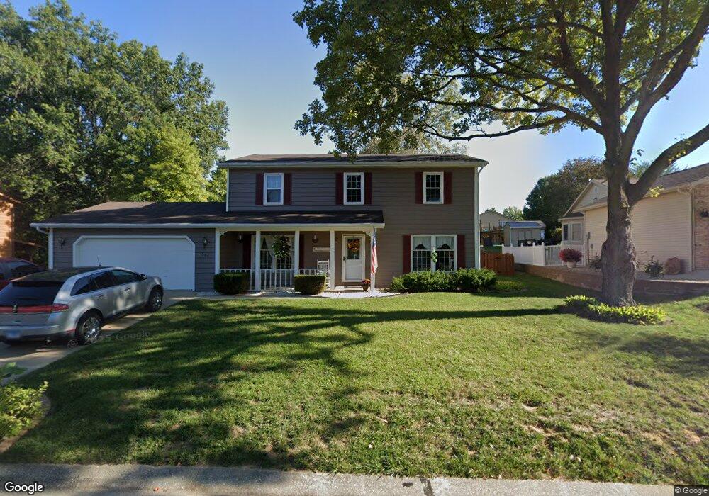
305 Chesapeake Ln Collinsville, IL 62234
Estimated Value: $277,366 - $350,000
3
Beds
4
Baths
1,080
Sq Ft
$289/Sq Ft
Est. Value
About This Home
This home is located at 305 Chesapeake Ln, Collinsville, IL 62234 and is currently estimated at $312,592, approximately $289 per square foot. 305 Chesapeake Ln is a home located in Madison County with nearby schools including John A Renfro Elementary School, Dorris Intermediate School, and Collinsville Middle School.
Ownership History
Date
Name
Owned For
Owner Type
Purchase Details
Closed on
Sep 26, 2003
Sold by
Lotz James W and Lotz Judy L
Bought by
Blasingame James L and Blasingame Bonnie B
Current Estimated Value
Home Financials for this Owner
Home Financials are based on the most recent Mortgage that was taken out on this home.
Original Mortgage
$169,100
Outstanding Balance
$79,939
Interest Rate
6.4%
Mortgage Type
Purchase Money Mortgage
Estimated Equity
$232,653
Create a Home Valuation Report for This Property
The Home Valuation Report is an in-depth analysis detailing your home's value as well as a comparison with similar homes in the area
Home Values in the Area
Average Home Value in this Area
Purchase History
| Date | Buyer | Sale Price | Title Company |
|---|---|---|---|
| Blasingame James L | $178,000 | Abstracts & Titles Inc |
Source: Public Records
Mortgage History
| Date | Status | Borrower | Loan Amount |
|---|---|---|---|
| Open | Blasingame James L | $169,100 |
Source: Public Records
Tax History Compared to Growth
Tax History
| Year | Tax Paid | Tax Assessment Tax Assessment Total Assessment is a certain percentage of the fair market value that is determined by local assessors to be the total taxable value of land and additions on the property. | Land | Improvement |
|---|---|---|---|---|
| 2024 | $4,935 | $83,190 | $14,650 | $68,540 |
| 2023 | $4,935 | $75,720 | $13,330 | $62,390 |
| 2022 | $4,589 | $70,020 | $12,330 | $57,690 |
| 2021 | $4,129 | $65,780 | $11,580 | $54,200 |
| 2020 | $3,962 | $62,760 | $11,050 | $51,710 |
| 2019 | $4,118 | $64,530 | $10,310 | $54,220 |
| 2018 | $4,012 | $61,130 | $9,770 | $51,360 |
| 2017 | $4,010 | $59,920 | $9,580 | $50,340 |
| 2016 | $4,214 | $59,920 | $9,580 | $50,340 |
| 2015 | $3,967 | $58,360 | $9,330 | $49,030 |
| 2014 | $3,967 | $58,360 | $9,330 | $49,030 |
| 2013 | $3,967 | $58,360 | $9,330 | $49,030 |
Source: Public Records
Map
Nearby Homes
- 414 Bunker Hill Dr
- 22 Brookwood Dr
- 5 Brookwood Dr
- 2007 Belt Line Rd
- 10 White Lily Dr
- 1224 Cedar Ridge Ct
- 1121 Carraway Ct
- 0 N Keebler Ave
- 1059 Lafayette Ct Unit A
- 1035 Lafayette Ct Unit B
- 1051 Lafayette Ct Unit A
- 203 Greenfield Dr
- 123 Elliot St
- 0 Strong Ave
- 308 Brown Ave
- 1120 Williams St
- 617 N Morrison Ave
- 123 W Wickliffe Ave
- 1210 Constance St
- 100 Debbie Dr
- 307 Chesapeake Ln
- 303 Chesapeake Ln
- 306 Jamestown Ct
- 304 Jamestown Ct
- 308 Jamestown Ct
- 302 Jamestown Ct
- 309 Chesapeake Ln
- 302 Chesapeake Ln
- 311 Chesapeake Ln
- 301 Chesapeake Ln
- 308 Chesapeake Ln
- 304 Chesapeake Ln
- 300 Chesapeake Ln
- 300 Jamestown Ct
- 310 Jamestown Ct
- 307 Jamestown Ct
- 309 Jamestown Ct
- 305 Jamestown Ct
- 311 Jamestown Ct
- 303 Jamestown Ct