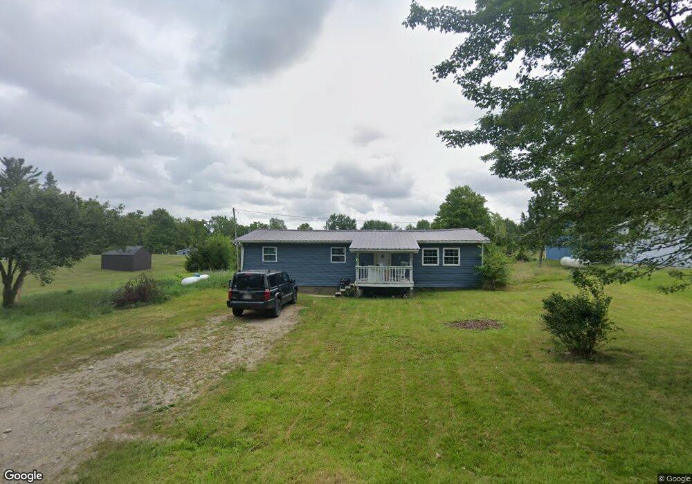
305 Chester Ave Camden, MI 49232
Estimated Value: $89,125 - $181,000
--
Bed
1
Bath
1,104
Sq Ft
$124/Sq Ft
Est. Value
About This Home
This home is located at 305 Chester Ave, Camden, MI 49232 and is currently estimated at $137,031, approximately $124 per square foot. 305 Chester Ave is a home located in Hillsdale County with nearby schools including Camden-Frontier K-8 School, Camden-Frontier High School, and Ridgeview Camden School.
Ownership History
Date
Name
Owned For
Owner Type
Purchase Details
Closed on
Sep 30, 2020
Sold by
Kyser Stephanie
Bought by
Rodriguez Rudolfo G and Rodriguez Charlotte Anne
Current Estimated Value
Purchase Details
Closed on
Aug 1, 2011
Sold by
Kerr Martin and Kerr Karen
Bought by
Wilder Susan Delores
Purchase Details
Closed on
Jan 31, 2003
Sold by
Hickman Dan H and Hickman Deborah S
Bought by
Kerr Martin and Kerr Karen
Purchase Details
Closed on
Mar 15, 1993
Bought by
Garnett and Hickman Deborah S
Purchase Details
Closed on
Dec 15, 1983
Bought by
Poole
Purchase Details
Closed on
Jun 15, 1983
Bought by
State Of Michigan
Create a Home Valuation Report for This Property
The Home Valuation Report is an in-depth analysis detailing your home's value as well as a comparison with similar homes in the area
Home Values in the Area
Average Home Value in this Area
Purchase History
| Date | Buyer | Sale Price | Title Company |
|---|---|---|---|
| Rodriguez Rudolfo G | $13,600 | None Available | |
| Wilder Susan Delores | $52,500 | None Available | |
| Kerr Martin | $45,000 | -- | |
| Garnett | $18,000 | -- | |
| Poole | -- | -- | |
| State Of Michigan | -- | -- |
Source: Public Records
Tax History Compared to Growth
Tax History
| Year | Tax Paid | Tax Assessment Tax Assessment Total Assessment is a certain percentage of the fair market value that is determined by local assessors to be the total taxable value of land and additions on the property. | Land | Improvement |
|---|---|---|---|---|
| 2025 | $1,518 | $34,800 | $0 | $0 |
| 2024 | $579 | $42,000 | $0 | $0 |
| 2023 | $555 | $39,000 | $0 | $0 |
| 2022 | $1,383 | $27,400 | $0 | $0 |
| 2021 | $1,341 | $26,300 | $0 | $0 |
| 2020 | $880 | $25,500 | $0 | $0 |
| 2019 | $859 | $24,400 | $0 | $0 |
| 2018 | $836 | $16,200 | $0 | $0 |
| 2017 | $827 | $17,260 | $0 | $0 |
| 2016 | $1,067 | $16,420 | $0 | $0 |
| 2015 | $180 | $16,420 | $0 | $0 |
| 2013 | $230 | $21,020 | $0 | $0 |
| 2012 | $227 | $20,750 | $0 | $0 |
Source: Public Records
Map
Nearby Homes
- 423 Fairview Ave
- 214 Miller St
- 202 W Bell St
- 9677 W Camden Rd
- 12208 Maple St
- 9874 Highland Dr
- 9911 Lake Dr
- 115 N Michigan St
- 8833 W Territorial Rd
- 8800 W Territorial Rd
- 0 W Territorial Rd Unit 25043960
- 116 Chapel Avenue Clear Lake
- 15791 Rice Rd
- 0 Dimmers Rd
- 5-50 County Rd S
- 35 John Ct
- 9949 Indian Trail
- 18405 County Road 2-50
- 7944 Gilmore Rd
- 120 Sunset Bay Ct
- 309 Chester Ave
- 313 Chester Ave
- 215 E Bell St
- 211 E Bell St
- 119 E Bell St
- 313 Fairview Ave
- 305 Fairview Ave
- 309 Fairview Ave
- 432 Fairview Ave
- 117 E Bell St
- 225 E Bell St
- 315 Chester Ave
- 212 E Bell St
- 202 E Bell St
- 202 E Bell St
- 206 E Bell St
- 315 Fairview Ave
- 114 E Bell St
- 302 E Bell St
- 319 Fairview Ave