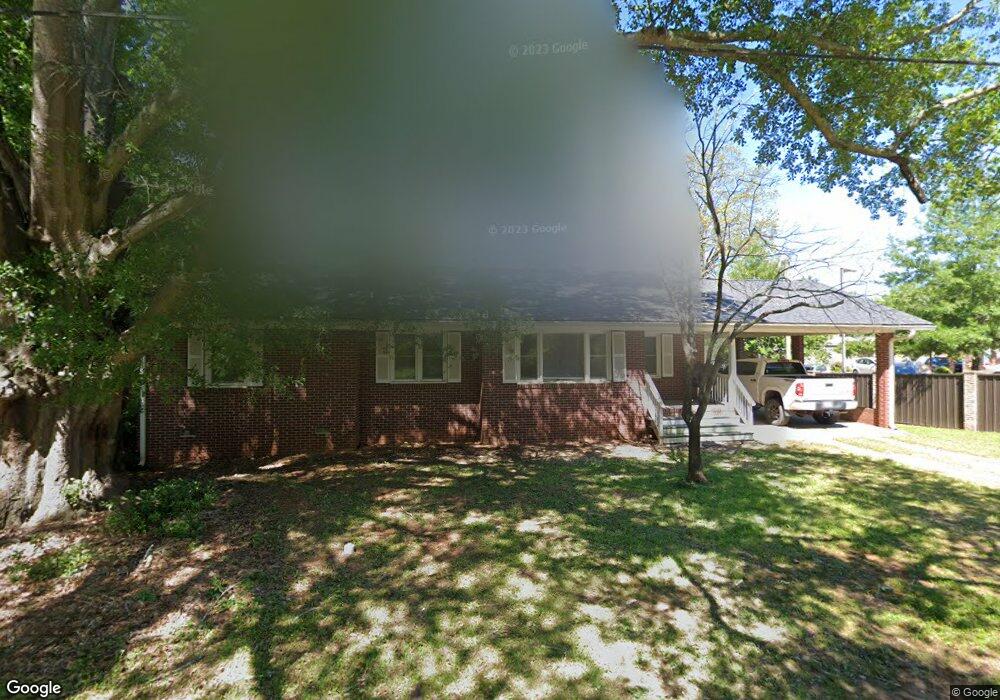
305 Clark St Chapin, SC 29036
Estimated Value: $227,426
3
Beds
2
Baths
1,499
Sq Ft
$152/Sq Ft
Est. Value
About This Home
This home is located at 305 Clark St, Chapin, SC 29036 and is currently estimated at $227,426, approximately $151 per square foot. 305 Clark St is a home located in Lexington County with nearby schools including Chapin Elementary School, Chapin Intermediate, and Chapin High School.
Ownership History
Date
Name
Owned For
Owner Type
Purchase Details
Closed on
Dec 18, 2024
Sold by
Irons Michael and Irons Lisa
Bought by
Kings Flame Llc
Current Estimated Value
Purchase Details
Closed on
Jun 16, 2021
Sold by
Mcdermet Mark and Mcdermet Debbie B
Bought by
Irons Michael and Irons Lisa
Purchase Details
Closed on
Jun 14, 2021
Sold by
Mcabee Perry Andrew
Bought by
Mcdermet Mark and Mcdermet Debbie B
Purchase Details
Closed on
May 6, 2019
Sold by
Mcdermet Mark and Mcdermet Debbie B
Bought by
Mcdermet Mark and Mcdermet Debbie B
Create a Home Valuation Report for This Property
The Home Valuation Report is an in-depth analysis detailing your home's value as well as a comparison with similar homes in the area
Home Values in the Area
Average Home Value in this Area
Purchase History
| Date | Buyer | Sale Price | Title Company |
|---|---|---|---|
| Kings Flame Llc | -- | None Listed On Document | |
| Kings Flame Llc | -- | None Listed On Document | |
| Irons Michael | $173,500 | None Available | |
| Mcdermet Mark | -- | None Available | |
| Mcdermet Mark | $179,000 | None Available |
Source: Public Records
Tax History
| Year | Tax Paid | Tax Assessment Tax Assessment Total Assessment is a certain percentage of the fair market value that is determined by local assessors to be the total taxable value of land and additions on the property. | Land | Improvement |
|---|---|---|---|---|
| 2024 | $4,773 | $9,549 | $3,379 | $6,170 |
| 2023 | $4,297 | $9,549 | $3,379 | $6,170 |
| 2022 | $4,065 | $9,549 | $3,379 | $6,170 |
| 2020 | $3,738 | $8,636 | $3,332 | $5,304 |
| 2019 | $3,349 | $7,509 | $3,488 | $4,021 |
| 2018 | $3,199 | $7,509 | $3,488 | $4,021 |
| 2017 | $3,164 | $7,509 | $3,488 | $4,021 |
| 2016 | $3,142 | $7,508 | $3,488 | $4,020 |
| 2014 | $2,622 | $6,529 | $1,725 | $4,804 |
| 2013 | -- | $6,530 | $1,730 | $4,800 |
Source: Public Records
Map
Nearby Homes
- 0 Amicks Ferry Rd
- 0 E Boundary St
- 2458 Chapin Rd
- 120 W Horn Ct
- 100 Recluse St
- 308 Turkey Beard Ct
- 1-B Saint Peters Church Rd
- 1679 Amicks Ferry Rd
- 120 Tail Feather Way
- 317 Eagle Claw Dr
- 315 Eagle Claw Dr
- 562 Griffon Dr
- 578 Griffon Dr
- 570 Griffon Dr
- 582 Griffon Dr
- 590 Griffon Dr
- 575 Griffon Dr
- 598 Griffon Dr
- 602 Griffon Dr
- 606 Griffon Dr
- 0 Clark St Unit 433538
- 200 Lexington Ave
- 302 Clark St
- 133 Clark St
- 101 Water St
- 215 Lexington Ave
- 945 Chapin Rd
- 207 Lexington Ave
- 203 Lexington Ave
- S/S Highway 76
- 24298 Us Hwy 76
- 305 Lexington Ave
- 305 Lexington Ave
- 207 Beaufort St
- 200 Clark St
- 200 Clark St Unit 300
- 200 Clark St Unit 121
- 200 Clark St Unit 115
- 200 Clark St Unit 113
- 200 Clark St Unit 105
Your Personal Tour Guide
Ask me questions while you tour the home.