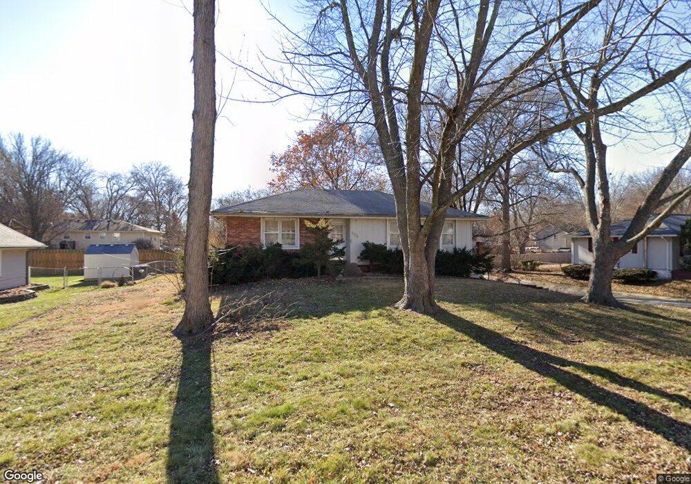
305 E 10th St Kearney, MO 64060
Estimated Value: $258,000 - $272,000
3
Beds
2
Baths
1,192
Sq Ft
$221/Sq Ft
Est. Value
About This Home
This home is located at 305 E 10th St, Kearney, MO 64060 and is currently estimated at $263,321, approximately $220 per square foot. 305 E 10th St is a home located in Clay County with nearby schools including Kearney Junior High School, Kearney High School, and Northern Hills Christian Academy.
Ownership History
Date
Name
Owned For
Owner Type
Purchase Details
Closed on
Feb 10, 2006
Sold by
Meyers Richard R and Meyers Barbara J
Bought by
Brown Julie M
Current Estimated Value
Home Financials for this Owner
Home Financials are based on the most recent Mortgage that was taken out on this home.
Original Mortgage
$103,200
Outstanding Balance
$57,925
Interest Rate
6.15%
Mortgage Type
Fannie Mae Freddie Mac
Estimated Equity
$205,396
Purchase Details
Closed on
Apr 20, 2005
Sold by
Black Margery E
Bought by
Meyers Richard R and Meyers Barbara J
Home Financials for this Owner
Home Financials are based on the most recent Mortgage that was taken out on this home.
Original Mortgage
$105,000
Interest Rate
5.89%
Mortgage Type
Purchase Money Mortgage
Purchase Details
Closed on
Jun 19, 2000
Sold by
Gibson Annetta L
Bought by
Black Margery E
Create a Home Valuation Report for This Property
The Home Valuation Report is an in-depth analysis detailing your home's value as well as a comparison with similar homes in the area
Home Values in the Area
Average Home Value in this Area
Purchase History
| Date | Buyer | Sale Price | Title Company |
|---|---|---|---|
| Brown Julie M | -- | Thomson Title Corporation | |
| Meyers Richard R | -- | Advantage Title Llc | |
| Black Margery E | $108,000 | First American Title Ins Co |
Source: Public Records
Mortgage History
| Date | Status | Borrower | Loan Amount |
|---|---|---|---|
| Open | Brown Julie M | $103,200 | |
| Previous Owner | Meyers Richard R | $105,000 |
Source: Public Records
Tax History
| Year | Tax Paid | Tax Assessment Tax Assessment Total Assessment is a certain percentage of the fair market value that is determined by local assessors to be the total taxable value of land and additions on the property. | Land | Improvement |
|---|---|---|---|---|
| 2025 | $2,120 | $33,440 | -- | -- |
| 2024 | $2,120 | $30,930 | -- | -- |
| 2023 | $2,112 | $30,930 | $0 | $0 |
| 2022 | $2,031 | $26,350 | $0 | $0 |
| 2021 | $1,824 | $26,353 | $3,800 | $22,553 |
| 2020 | $1,856 | $24,380 | $0 | $0 |
| 2019 | $1,846 | $24,380 | $0 | $0 |
Source: Public Records
Map
Nearby Homes
- 200 E 10th St
- 402 E 14th St
- 1304 S Jefferson St
- 1300 Robin Cir
- 1202 Noah's Ln
- 1204 Noah's Ln
- 1102 Susan St
- 1209 Noah's Ln
- 623 E 13th St
- 905 Susan St
- 303 W 11th St
- 1307 Stonecrest Dr
- 1302 Regency Dr
- 201 S Marimack Dr
- 1702 Bay Ct
- 1710 Rockwater Ln
- 1300 Melissa Ct
- 704 Feldspar St
- 1933 Meadowlane
- 709 Feldspar St
Your Personal Tour Guide
Ask me questions while you tour the home.