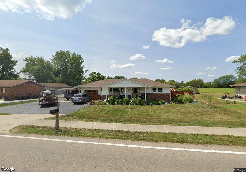
305 Elm St London, OH 43140
Estimated Value: $288,000 - $345,000
2
Beds
2
Baths
1,176
Sq Ft
$271/Sq Ft
Est. Value
About This Home
This home is located at 305 Elm St, London, OH 43140 and is currently estimated at $319,077, approximately $271 per square foot. 305 Elm St is a home located in Madison County with nearby schools including London Elementary School, London Middle School, and London High School.
Ownership History
Date
Name
Owned For
Owner Type
Purchase Details
Closed on
Nov 30, 2004
Sold by
Rinehart Charles W
Bought by
Dolby Mathew J
Current Estimated Value
Home Financials for this Owner
Home Financials are based on the most recent Mortgage that was taken out on this home.
Original Mortgage
$100,000
Outstanding Balance
$50,380
Interest Rate
5.82%
Mortgage Type
Unknown
Estimated Equity
$268,697
Create a Home Valuation Report for This Property
The Home Valuation Report is an in-depth analysis detailing your home's value as well as a comparison with similar homes in the area
Home Values in the Area
Average Home Value in this Area
Purchase History
| Date | Buyer | Sale Price | Title Company |
|---|---|---|---|
| Dolby Mathew J | $125,000 | Midland Title West |
Source: Public Records
Mortgage History
| Date | Status | Borrower | Loan Amount |
|---|---|---|---|
| Open | Dolby Mathew J | $100,000 | |
| Closed | Dolby Mathew J | $12,500 |
Source: Public Records
Tax History Compared to Growth
Tax History
| Year | Tax Paid | Tax Assessment Tax Assessment Total Assessment is a certain percentage of the fair market value that is determined by local assessors to be the total taxable value of land and additions on the property. | Land | Improvement |
|---|---|---|---|---|
| 2024 | $2,644 | $86,500 | $10,580 | $75,920 |
| 2023 | $2,644 | $86,500 | $10,580 | $75,920 |
| 2022 | $2,344 | $70,140 | $8,890 | $61,250 |
| 2021 | $2,334 | $70,140 | $8,890 | $61,250 |
| 2020 | $2,335 | $70,140 | $8,890 | $61,250 |
| 2019 | $1,948 | $57,890 | $8,480 | $49,410 |
| 2018 | $2,114 | $57,800 | $8,480 | $49,320 |
| 2017 | $1,719 | $57,800 | $8,480 | $49,320 |
| 2016 | $1,730 | $48,900 | $8,480 | $40,420 |
| 2015 | $1,982 | $48,900 | $8,480 | $40,420 |
| 2014 | $1,982 | $48,900 | $8,480 | $40,420 |
| 2013 | -- | $52,940 | $11,960 | $40,980 |
Source: Public Records
Map
Nearby Homes
- 418 Quincy Cir
- 345 Jacob Ln
- Spruce Plan at London Landing at Brooksedge
- Walnut Plan at London Landing at Brooksedge
- Palmetto Plan at London Landing at Brooksedge
- Ironwood Plan at London Landing at Brooksedge
- Norway Plan at London Landing at Brooksedge
- Aspen II Plan at London Landing at Brooksedge
- Ashton Plan at London Landing at Brooksedge
- Bradford Plan at London Landing at Brooksedge
- Cooper Plan at London Landing at Brooksedge
- Juniper Plan at London Landing at Brooksedge
- Empress Plan at London Landing at Brooksedge
- 347 Jacob Ln
- Chestnut Plan at London Landing at Brooksedge
- 233 Maddoxx Dr
- 205 Lafayette St
- 437 Lukes Cir
- 292 N Main St
- 618 Lois Ln