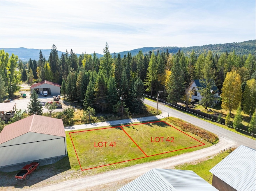
305 Ferndale Dr Unit 41 Bigfork, MT 59911
Estimated payment $649/month
Highlights
- Views of Trees
- No HOA
- Level Lot
About This Lot
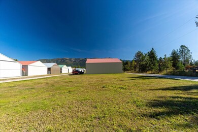
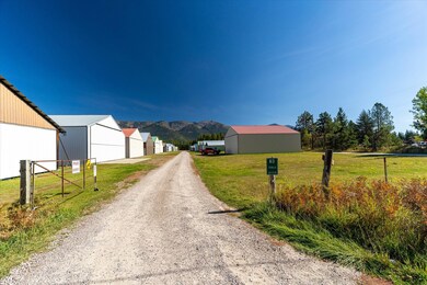
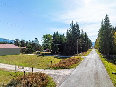
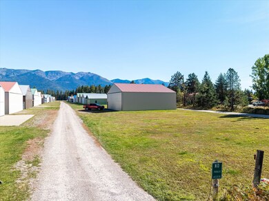
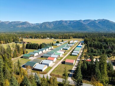
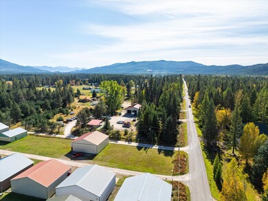
Lot 41 of Aero Lane Hangers Ferndale, ready for your hanger and aircraft. Ferndale Airfield (FAA LID: 53U) is a public use airport in Flathead County, Montana, United States. It is owned by the Flathead Municipal Airport Authority and located three nautical miles northeast of the central business district of Bigfork, Montana. The airfield is county-maintained year around at no cost to hangar owners and renters. Ferndale Airfield covers an area of 35 well maintained acres at an elevation of 3,072 feet above mean sea level. It has one runway designated 15/33 with a turf surface measuring 3,500 by 95 feet. Per the CCR's, personal storage is allowed inside of a hangar. Seller is willing to owner finance and is open to considering trades.
Listing Agent
National Parks Realty - Bigfork License #RRE-RBS-LIC-87841 Listed on: 10/04/2024
Property Details
Property Type
- Land
Est. Annual Taxes
- $235
Lot Details
- 5,227 Sq Ft Lot
- Property fronts a county road
- Level Lot
Property Views
- Trees
- Mountain
Community Details
- No Home Owners Association
Listing and Financial Details
- Assessor Parcel Number 07383634206090000
Map
Home Values in the Area
Average Home Value in this Area
Tax History
| Year | Tax Paid | Tax Assessment Tax Assessment Total Assessment is a certain percentage of the fair market value that is determined by local assessors to be the total taxable value of land and additions on the property. | Land | Improvement |
|---|---|---|---|---|
| 2025 | $214 | $79,769 | $0 | $0 |
| 2024 | $228 | $47,927 | $0 | $0 |
| 2023 | $248 | $47,927 | $0 | $0 |
| 2022 | $195 | $29,342 | $0 | $0 |
| 2021 | $206 | $29,342 | $0 | $0 |
| 2020 | $188 | $26,000 | $0 | $0 |
| 2019 | $198 | $26,000 | $0 | $0 |
| 2018 | $162 | $21,622 | $0 | $0 |
| 2017 | $150 | $21,622 | $0 | $0 |
| 2016 | $149 | $20,342 | $0 | $0 |
| 2015 | $140 | $20,342 | $0 | $0 |
| 2014 | $176 | $15,709 | $0 | $0 |
Property History
| Date | Event | Price | List to Sale | Price per Sq Ft |
|---|---|---|---|---|
| 06/24/2025 06/24/25 | For Sale | $119,000 | 0.0% | -- |
| 04/24/2025 04/24/25 | Off Market | -- | -- | -- |
| 10/04/2024 10/04/24 | For Sale | $119,000 | -- | -- |
Purchase History
| Date | Type | Sale Price | Title Company |
|---|---|---|---|
| Warranty Deed | -- | None Available | |
| Warranty Deed | -- | None Available | |
| Warranty Deed | -- | Allinace Title |
Source: Montana Regional MLS
MLS Number: 30034731
APN: 07-3836-34-2-06-09-0000
Disclaimer: Certain information contained herein is derived from information provided by parties other than Homes.com. All information provided is deemed reliable, but is not guaranteed to be accurate and should be independently verified.
![]() IDX information is provided exclusively for personal, non-commercial use, and may not be used for any purpose other than to identify prospective properties consumers may be interested in purchasing. Information is deemed reliable but not guaranteed.
IDX information is provided exclusively for personal, non-commercial use, and may not be used for any purpose other than to identify prospective properties consumers may be interested in purchasing. Information is deemed reliable but not guaranteed.
- 305 Ferndale Dr Unit 41&42
- 305 Ferndale Dr Unit 42
- 220 Ferndale Dr
- 115 Ferndale Dr
- 518 Eastman Dr
- 639 Three Eagle Ln
- 945 Swan River Rd
- 936 Swan River Rd
- Nhn Watchman Way
- 1080 Mt Highway 209
- 280 Shady Ln
- 285 Shady Ln
- 172 Swanlea Rd S
- 30580 Cayuse Ln
- 25 Starview Dr
- 1150 Swan Hill Dr
- 110 Landmark Ln
- 11974 Mt Highway 83
- 12022 Mount Highway 83
- 183 Pinto Trail
- 14847 Montana Hwy 35 Unit 3
- 166 Jewel Basin Ct
- 33146 Orchard Dr
- 185 Golf Terrace Dr Unit E
- 185 Golf Terrace Dr Unit 185E
- 2048 Marina Ct
- 1120 Holt Dr Unit Suite A
- 1905 La Brant Rd
- 356 S Many Lakes Dr
- 124 Woodacres Dr
- 323 Deer Creek Rd Unit ID1038983P
- 396 N Juniper Bay Rd
- 1815 Lower Valley Rd
- 325 Spring Creek Rd
- 101 Kynzie Ln
- 1399 Destiny Ln
- 1430 3rd Ave E Unit 2
- 1430 3rd Ave E Unit 12
- 1430 3rd Ave E Unit 1
- 1430 3rd Ave E Unit 9
