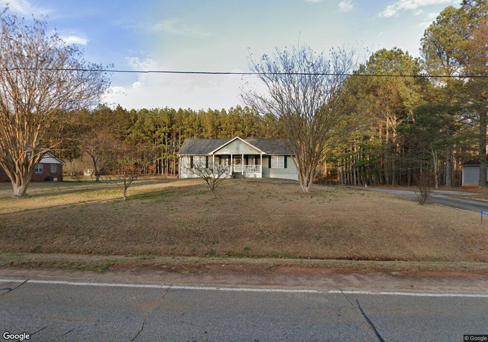
305 Harve Mathis Rd Athens, GA 30601
Estimated Value: $237,619 - $298,000
Studio
--
Bath
1,352
Sq Ft
$204/Sq Ft
Est. Value
About This Home
This home is located at 305 Harve Mathis Rd, Athens, GA 30601 and is currently estimated at $275,405, approximately $203 per square foot. 305 Harve Mathis Rd is a home located in Clarke County with nearby schools including Judia Jackson Harris Elementary School, Coile Middle School, and Cedar Shoals High School.
Ownership History
Date
Name
Owned For
Owner Type
Purchase Details
Closed on
Mar 28, 2005
Sold by
Whitfield Pamela S
Bought by
Whitfield H Dennis and Whitfield Pamela S
Current Estimated Value
Purchase Details
Closed on
Sep 23, 1994
Sold by
White Danny J
Bought by
Whitfield Pamela S
Purchase Details
Closed on
Jan 26, 1994
Sold by
Coggins Land Co
Bought by
White Danny J
Create a Home Valuation Report for This Property
The Home Valuation Report is an in-depth analysis detailing your home's value as well as a comparison with similar homes in the area
Purchase History
| Date | Buyer | Sale Price | Title Company |
|---|---|---|---|
| Whitfield H Dennis | -- | -- | |
| Whitfield Pamela S | $62,100 | -- | |
| White Danny J | $6,000 | -- |
Source: Public Records
Tax History
| Year | Tax Paid | Tax Assessment Tax Assessment Total Assessment is a certain percentage of the fair market value that is determined by local assessors to be the total taxable value of land and additions on the property. | Land | Improvement |
|---|---|---|---|---|
| 2025 | $1,333 | $90,575 | $12,000 | $78,575 |
| 2024 | $1,333 | $84,576 | $12,000 | $72,576 |
| 2023 | $222 | $76,749 | $12,000 | $64,749 |
| 2022 | $1,380 | $69,294 | $12,000 | $57,294 |
| 2021 | $1,252 | $54,515 | $10,800 | $43,715 |
| 2020 | $1,178 | $49,093 | $10,800 | $38,293 |
| 2019 | $1,156 | $46,840 | $10,800 | $36,040 |
| 2018 | $1,087 | $42,014 | $10,800 | $31,214 |
| 2017 | $1,090 | $42,139 | $10,800 | $31,339 |
| 2016 | $1,095 | $42,490 | $10,800 | $31,690 |
| 2015 | $1,100 | $42,842 | $10,800 | $32,042 |
| 2014 | $1,078 | $41,766 | $10,800 | $30,966 |
Source: Public Records
Map
Nearby Homes
- 1309 Hull Rd
- 3013 Lawton Ln
- 1361 Hull Rd
- 741 Harve Mathis Rd
- 540 & 542 Harve Mathis Rd
- 105 Hidden Lake Ct
- 19 Glenn Carrie Rd
- 232 Glenn Carrie Rd Unit 1
- 240 Glenn Carrie Rd Unit 2
- 789 Glenn Carrie Rd
- 73 Woodale St
- 0 Reese Ln Unit 7703910
- 0 Reese Ln Unit CL346847
- 3080 Danielsville Rd
- 8986 Highway 29 S
- 270 Norwood Cir
- 151 Rolling Woods Ln
- 31 Rolling Woods Ln
- 269 Norwood Ln
- 1080 Spratlin Mill Dr
- 304 Harve Mathis Rd
- 102 Harve Mathis Rd Unit 27B
- 102 Harve Mathis Rd
- 303 Harve Mathis Rd
- 137 Harve Mathis Rd
- 135 Harve Mathis Rd
- 302 Harve Mathis Rd
- 168 Fox Hall Trail Unit 21B
- 168 Fox Hall Trail
- 164 Fox Hall Trail Unit 20B
- 164 Fox Hall Trail
- 172 Fox Hall Trail Unit 22B
- 172 Fox Hall Trail
- 1299 Hull Rd
- 147 Harve Mathis Rd
- 1305 Hull Rd
- 160 Fox Hall Trail Unit 19B
- 160 Fox Hall Trail
- 300 Harve Mathis Rd
- 176 Fox Hall Trail Unit 23B
Your Personal Tour Guide
Ask me questions while you tour the home.