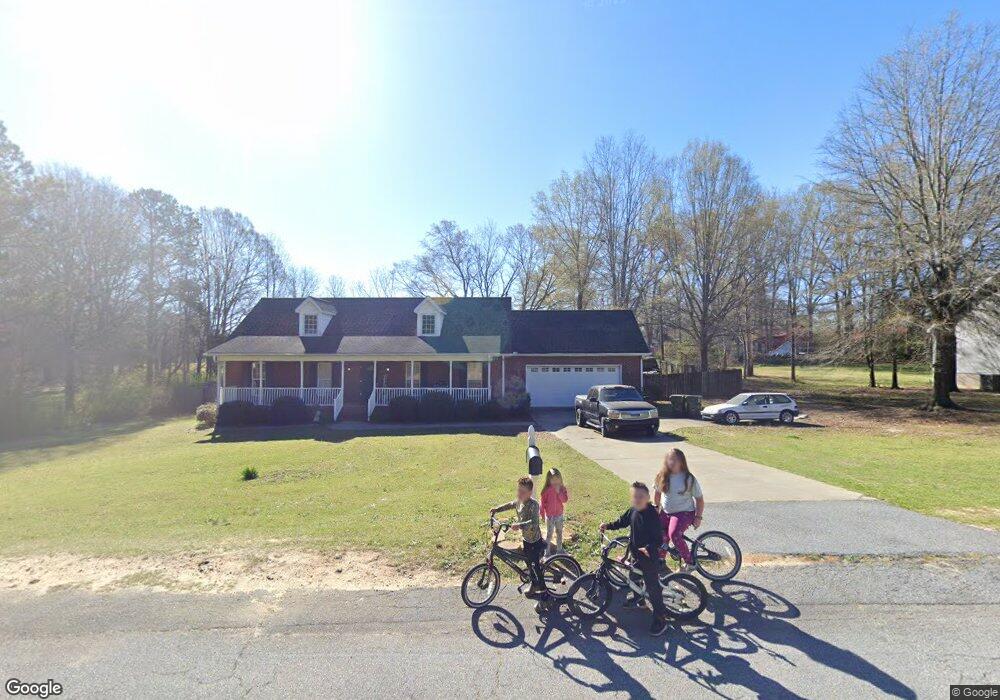
305 Harvey Dr Honea Path, SC 29654
Estimated Value: $355,000 - $432,000
4
Beds
2
Baths
2,834
Sq Ft
$135/Sq Ft
Est. Value
About This Home
This home is located at 305 Harvey Dr, Honea Path, SC 29654 and is currently estimated at $382,806, approximately $135 per square foot. 305 Harvey Dr is a home located in Anderson County with nearby schools including Belton Honea Path High School and Whispering Pines Mennonite School.
Ownership History
Date
Name
Owned For
Owner Type
Purchase Details
Closed on
Sep 15, 2022
Sold by
Depree Morris Ashley
Bought by
Morris Marco Antonio
Current Estimated Value
Home Financials for this Owner
Home Financials are based on the most recent Mortgage that was taken out on this home.
Original Mortgage
$258,852
Outstanding Balance
$246,967
Interest Rate
5.75%
Mortgage Type
FHA
Estimated Equity
$135,839
Purchase Details
Closed on
Oct 24, 2019
Sold by
Phillips Justin W and Phillips Ramanda H
Bought by
Morris Marco Antonio and Morris Ashley Depree
Home Financials for this Owner
Home Financials are based on the most recent Mortgage that was taken out on this home.
Original Mortgage
$140,000
Interest Rate
3.5%
Mortgage Type
New Conventional
Purchase Details
Closed on
Nov 18, 2005
Sold by
C&F Development Co Inc
Bought by
Phillips Justin W and Phillips Ramanda H
Home Financials for this Owner
Home Financials are based on the most recent Mortgage that was taken out on this home.
Original Mortgage
$154,750
Interest Rate
5.75%
Mortgage Type
Construction
Create a Home Valuation Report for This Property
The Home Valuation Report is an in-depth analysis detailing your home's value as well as a comparison with similar homes in the area
Home Values in the Area
Average Home Value in this Area
Purchase History
| Date | Buyer | Sale Price | Title Company |
|---|---|---|---|
| Morris Marco Antonio | -- | -- | |
| Morris Marco Antonio | $218,000 | None Available | |
| Phillips Justin W | $8,000 | -- |
Source: Public Records
Mortgage History
| Date | Status | Borrower | Loan Amount |
|---|---|---|---|
| Open | Morris Marco Antonio | $258,852 | |
| Previous Owner | Morris Marco Antonio | $140,000 | |
| Previous Owner | Phillips Justin W | $154,750 |
Source: Public Records
Tax History
| Year | Tax Paid | Tax Assessment Tax Assessment Total Assessment is a certain percentage of the fair market value that is determined by local assessors to be the total taxable value of land and additions on the property. | Land | Improvement |
|---|---|---|---|---|
| 2024 | $2,694 | $10,560 | $500 | $10,060 |
| 2023 | $2,627 | $10,560 | $500 | $10,060 |
| 2022 | $2,531 | $10,560 | $500 | $10,060 |
| 2021 | $2,178 | $8,770 | $400 | $8,370 |
| 2020 | $2,153 | $8,770 | $400 | $8,370 |
| 2019 | $2,563 | $10,730 | $400 | $10,330 |
| 2018 | $2,563 | $10,730 | $400 | $10,330 |
| 2017 | -- | $10,730 | $400 | $10,330 |
| 2016 | $2,225 | $10,530 | $240 | $10,290 |
| 2015 | $2,325 | $10,530 | $240 | $10,290 |
| 2014 | $2,339 | $10,530 | $240 | $10,290 |
Source: Public Records
Map
Nearby Homes
- 112 Brookside Cir
- 310 Oak Dr
- 704 Sherwood Ave
- 701 W Greer St
- 00 Brook St
- 2 Heyward Ave
- 520 Elizabeth Street Extension
- 305 Tribble St
- 307 Tribble St
- 00 Ervin St
- 302 W Hampton Ave
- 7 Carlisle Dr
- 227 S Main St
- 417 N Main St
- 5 George St
- 600 N Main St
- 511 N Main St
- 20 Sanders St
- 229 Armstrong Rd
- 1 E McGee St
- 307 Harvey Dr
- 103 Quail Trail
- 301 Harvey Dr
- 1008 Sauer Farm Rd
- 306 Harvey Dr
- 105 Quail Trail
- 104 State Road S-4-1053
- 104 Quail Trail
- 315 Harvey Dr
- 0 Sauer Farm Rd Unit 1467910
- 0 Sauer Farm Rd
- 107 Quail Trail
- 308 Harvey Dr
- 106 Quail Trail
- 107 State Road S-4-1053
- 235 Harvey Dr
- 103 Maple Leaf Dr
- 117 Woodside Dr
- 236 Harvey Dr
- 960 Sauer Farm Rd
Your Personal Tour Guide
Ask me questions while you tour the home.