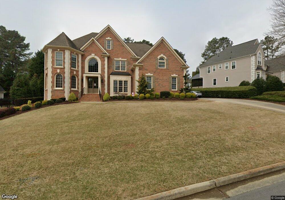
305 Hunstanton Ct Alpharetta, GA 30022
Estimated Value: $849,147 - $1,111,000
5
Beds
5
Baths
3,527
Sq Ft
$263/Sq Ft
Est. Value
About This Home
This home is located at 305 Hunstanton Ct, Alpharetta, GA 30022 and is currently estimated at $928,287, approximately $263 per square foot. 305 Hunstanton Ct is a home located in Fulton County with nearby schools including State Bridge Crossing Elementary School, Taylor Road Middle School, and Chattahoochee High School.
Ownership History
Date
Name
Owned For
Owner Type
Purchase Details
Closed on
May 4, 2015
Sold by
Chan Jason K
Bought by
Chan Jason K and Chan Huan Hao
Current Estimated Value
Purchase Details
Closed on
Apr 13, 2007
Sold by
Innovative Design Homes Inc
Bought by
Chan Jason K
Home Financials for this Owner
Home Financials are based on the most recent Mortgage that was taken out on this home.
Original Mortgage
$417,000
Interest Rate
6.1%
Mortgage Type
New Conventional
Create a Home Valuation Report for This Property
The Home Valuation Report is an in-depth analysis detailing your home's value as well as a comparison with similar homes in the area
Home Values in the Area
Average Home Value in this Area
Purchase History
| Date | Buyer | Sale Price | Title Company |
|---|---|---|---|
| Chan Jason K | -- | -- | |
| Chan Jason K | $581,700 | -- |
Source: Public Records
Mortgage History
| Date | Status | Borrower | Loan Amount |
|---|---|---|---|
| Previous Owner | Chan Jason K | $417,000 |
Source: Public Records
Tax History Compared to Growth
Tax History
| Year | Tax Paid | Tax Assessment Tax Assessment Total Assessment is a certain percentage of the fair market value that is determined by local assessors to be the total taxable value of land and additions on the property. | Land | Improvement |
|---|---|---|---|---|
| 2025 | $5,288 | $366,680 | $94,240 | $272,440 |
| 2023 | $5,789 | $205,080 | $56,920 | $148,160 |
| 2022 | $5,188 | $205,080 | $56,920 | $148,160 |
| 2021 | $5,163 | $199,120 | $55,280 | $143,840 |
| 2020 | $5,210 | $196,720 | $54,600 | $142,120 |
| 2019 | $591 | $193,240 | $53,640 | $139,600 |
| 2018 | $5,747 | $188,720 | $52,400 | $136,320 |
| 2017 | $4,817 | $153,680 | $41,320 | $112,360 |
| 2016 | $4,739 | $153,680 | $41,320 | $112,360 |
| 2015 | $4,791 | $153,680 | $41,320 | $112,360 |
| 2014 | -- | $153,680 | $41,320 | $112,360 |
Source: Public Records
Map
Nearby Homes
- 5170 Cameron Forest Pkwy
- 5640 Sandown Way
- 10296 Quadrant Ct Unit 76
- 10281 Midway Ave
- 230 Skidaway Ct
- 10265 Minion Ct Unit 27
- 10275 Groomsbridge Rd
- 220 Magnolia Tree Ct
- 10285 Groomsbridge Rd Unit 5
- 465 Mikasa Dr
- 5425 Taylor Rd Unit 2
- 230 Pinebridge Ct
- 10570 Bridgemor Dr
- 512 Winston Croft Cir Unit 57
- 510 Winston Croft Cir Unit 56
- 1003 Crown Oak St Unit 43
- 1005 Crown Oak St Unit 44
- 1007 Crown Oak St Unit 45
- 309 Hunstanton Ct
- 48 Creekside Park Dr
- 10540 Arlington Point
- 10550 Arlington Point
- 10560 Arlington Point
- 10570 Arlington Point
- 10580 Arlington Point Unit 10580
- 10555 Arlington Point
- 52 Creekside Park Dr
- 10565 Arlington Point
- 10590 Arlington Point Unit 10590
- 5403 Spey Ct
- 10575 Arlington Point
- 10600 Arlington Point Unit 10600
- 430 Bemiss Ct Unit 5
- 10515 Wren Ridge Rd
- 10585 Arlington Point
- 10610 Arlington Point
- 10610 Arlington Pointe Point Unit 10610
- 435 Bemiss Ct