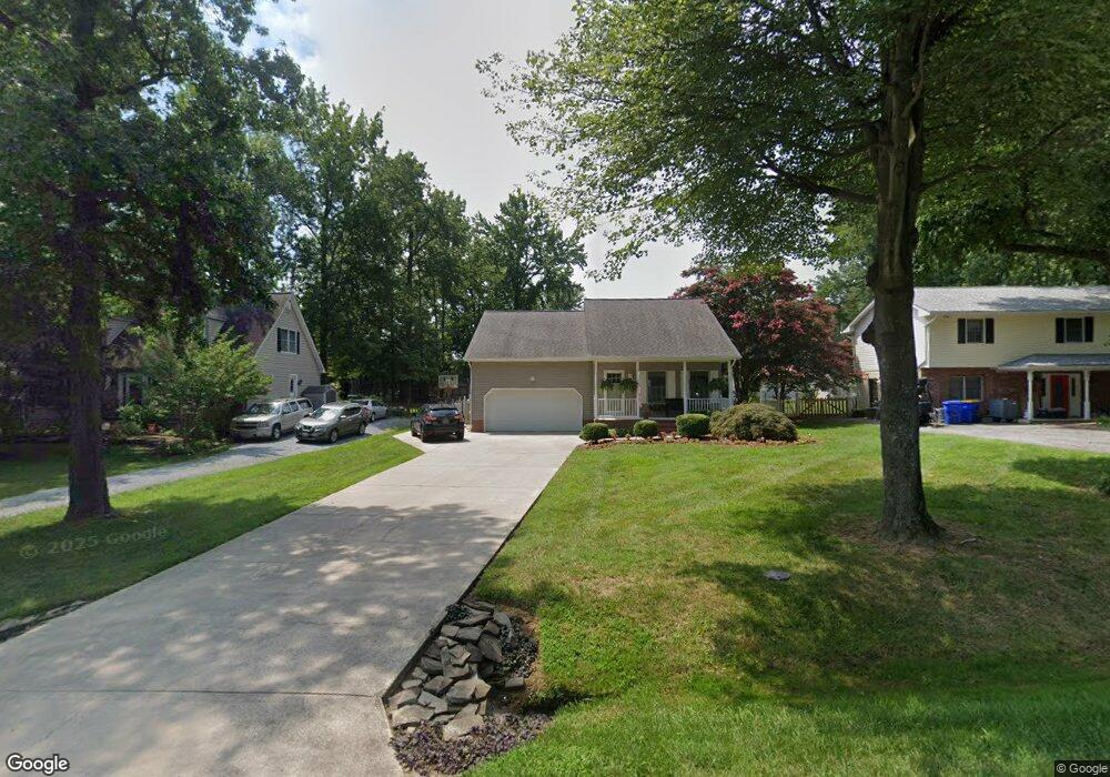
305 Mckay Rd Stevensville, MD 21666
Estimated Value: $581,000 - $745,000
--
Bed
3
Baths
3,170
Sq Ft
$215/Sq Ft
Est. Value
About This Home
This home is located at 305 Mckay Rd, Stevensville, MD 21666 and is currently estimated at $682,794, approximately $215 per square foot. 305 Mckay Rd is a home located in Queen Anne's County with nearby schools including Matapeake Elementary School, Matapeake Middle School, and Kent Island High School.
Ownership History
Date
Name
Owned For
Owner Type
Purchase Details
Closed on
Feb 21, 2025
Sold by
Bailey John M and Bailey Mary Beth
Bought by
Bailey Family Trust and Bailey
Current Estimated Value
Purchase Details
Closed on
Dec 18, 1997
Sold by
Johnson/Schulz Inc
Bought by
Bailey John M and Bailey Mary Beth
Create a Home Valuation Report for This Property
The Home Valuation Report is an in-depth analysis detailing your home's value as well as a comparison with similar homes in the area
Home Values in the Area
Average Home Value in this Area
Purchase History
| Date | Buyer | Sale Price | Title Company |
|---|---|---|---|
| Bailey Family Trust | -- | None Listed On Document | |
| Bailey Family Trust | -- | None Listed On Document | |
| Bailey John M | $174,500 | -- |
Source: Public Records
Mortgage History
| Date | Status | Borrower | Loan Amount |
|---|---|---|---|
| Closed | Bailey John M | -- |
Source: Public Records
Tax History Compared to Growth
Tax History
| Year | Tax Paid | Tax Assessment Tax Assessment Total Assessment is a certain percentage of the fair market value that is determined by local assessors to be the total taxable value of land and additions on the property. | Land | Improvement |
|---|---|---|---|---|
| 2025 | $4,735 | $551,367 | $0 | $0 |
| 2024 | $4,483 | $501,033 | $0 | $0 |
| 2023 | $4,246 | $450,700 | $161,000 | $289,700 |
| 2022 | $4,209 | $446,867 | $0 | $0 |
| 2021 | $4,212 | $443,033 | $0 | $0 |
| 2020 | $4,212 | $439,200 | $161,000 | $278,200 |
| 2019 | $4,138 | $431,433 | $0 | $0 |
| 2018 | $4,063 | $423,667 | $0 | $0 |
| 2017 | $3,989 | $415,900 | $0 | $0 |
| 2016 | -- | $407,900 | $0 | $0 |
| 2015 | $1,924 | $399,900 | $0 | $0 |
| 2014 | $1,924 | $391,900 | $0 | $0 |
Source: Public Records
Map
Nearby Homes
- 312 William Way
- 412 Bay City Rd
- 410 Stafford Rd
- 418 Bay City Rd
- 526 Victoria Dr
- 802 Broadcreek Dr
- 914 Chesapeake Dr
- 103 Irene Way
- 306 Irene Way
- 1000 Chesapeake Dr
- 440 Moorings Cir Unit 85
- 298 Moorings Cir
- 312 Topside Dr Unit 223
- 349 Topside Dr
- 736 Moorings Cir Unit 35
- 858 Moorings Cir Unit 11
- 0 Sunset Wharf Lot D-3 Unit MDQA2010280
- 119 Keenan Way
- 0 Sunset Wharf Lot D-1 Unit MDQA2010276
- 111 Keenan Way