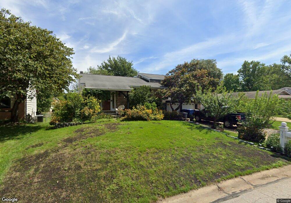
305 Morningside Dr Saint Peters, MO 63376
Estimated Value: $317,114 - $349,000
3
Beds
3
Baths
1,482
Sq Ft
$225/Sq Ft
Est. Value
About This Home
This home is located at 305 Morningside Dr, Saint Peters, MO 63376 and is currently estimated at $333,029, approximately $224 per square foot. 305 Morningside Dr is a home located in St. Charles County with nearby schools including Fairmount Elementary School, Saeger Middle School, and Francis Howell Central High School.
Ownership History
Date
Name
Owned For
Owner Type
Purchase Details
Closed on
Jul 13, 2007
Sold by
Harms George E and Harms Tonya S
Bought by
Harms Jeffrey B and Harms Amy M
Current Estimated Value
Home Financials for this Owner
Home Financials are based on the most recent Mortgage that was taken out on this home.
Original Mortgage
$132,000
Outstanding Balance
$82,677
Interest Rate
6.54%
Mortgage Type
Stand Alone Refi Refinance Of Original Loan
Estimated Equity
$250,352
Create a Home Valuation Report for This Property
The Home Valuation Report is an in-depth analysis detailing your home's value as well as a comparison with similar homes in the area
Home Values in the Area
Average Home Value in this Area
Purchase History
| Date | Buyer | Sale Price | Title Company |
|---|---|---|---|
| Harms Jeffrey B | $165,000 | Touchstone Title & Abstract |
Source: Public Records
Mortgage History
| Date | Status | Borrower | Loan Amount |
|---|---|---|---|
| Open | Harms Jeffrey B | $132,000 |
Source: Public Records
Tax History Compared to Growth
Tax History
| Year | Tax Paid | Tax Assessment Tax Assessment Total Assessment is a certain percentage of the fair market value that is determined by local assessors to be the total taxable value of land and additions on the property. | Land | Improvement |
|---|---|---|---|---|
| 2025 | $3,480 | $55,347 | -- | -- |
| 2023 | $3,476 | $49,769 | $0 | $0 |
| 2022 | $2,971 | $39,665 | $0 | $0 |
| 2021 | $2,966 | $39,665 | $0 | $0 |
| 2020 | $2,896 | $37,845 | $0 | $0 |
| 2019 | $2,886 | $37,845 | $0 | $0 |
| 2018 | $2,585 | $32,459 | $0 | $0 |
| 2017 | $2,573 | $32,459 | $0 | $0 |
| 2016 | $2,402 | $30,362 | $0 | $0 |
| 2015 | $2,398 | $30,362 | $0 | $0 |
| 2014 | $2,148 | $26,394 | $0 | $0 |
Source: Public Records
Map
Nearby Homes
- 5 Victoria Square
- 212 Agamemnon Ct
- 26 Jane Dr
- 1323 Pegasus Trail
- 38 Amberly Dr
- 309 Willott Square Dr
- 213 Candice Way
- 116 Willott Square Dr
- 221 Candice Way
- 1012 Windstream Dr Unit 21
- 1196 Colby Ct
- 31 Danson Dr
- Winslow Plan at Ryehill Manor
- Carver Plan at Ryehill Manor
- Stratton Plan at Ryehill Manor
- Lansford Plan at Ryehill Manor
- Brookmont Plan at Ryehill Manor
- Parker Plan at Ryehill Manor
- Waverly Plan at Ryehill Manor
- Whitehall Plan at Ryehill Manor
- 307 Morningside Dr
- 303 Morningside Dr
- 306 Kimberly Ln
- 308 Kimberly Ln
- 309 Morningside Dr
- 304 Kimberly Ln
- 301 Morningside Dr
- 208 Westminster Dr
- 310 Kimberly Ln
- 304 Morningside Dr
- 306 Morningside Dr
- 302 Morningside Dr
- 311 Morningside Dr
- 308 Morningside Dr
- 210 Westminster Dr
- 312 Kimberly Ln
- 300 Morningside Dr
- 0TBB the Victoria at Queensbrooke
- 313 Morningside Dr
- 1 Victoria Square