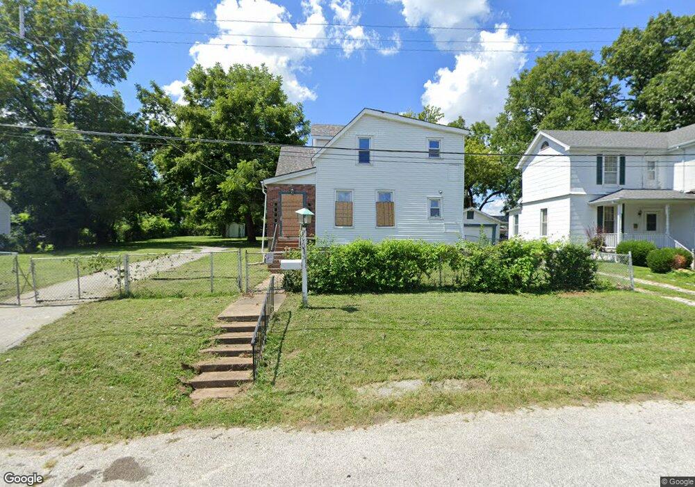
305 N Harvey Ave Saint Louis, MO 63135
Estimated Value: $80,000 - $147,000
4
Beds
2
Baths
1,624
Sq Ft
$69/Sq Ft
Est. Value
About This Home
This home is located at 305 N Harvey Ave, Saint Louis, MO 63135 and is currently estimated at $112,228, approximately $69 per square foot. 305 N Harvey Ave is a home located in St. Louis County with nearby schools including Ferguson Middle School, Johnson Wabash Elementary School, and McCluer High School.
Ownership History
Date
Name
Owned For
Owner Type
Purchase Details
Closed on
Aug 12, 2011
Sold by
U S Bank National Association Nd
Bought by
Moron Jose Gerardo Trujeque
Current Estimated Value
Purchase Details
Closed on
May 24, 2011
Sold by
Herin Bernice B
Bought by
U S Bank National Association Nd
Purchase Details
Closed on
Feb 23, 2011
Sold by
Schwenk Joseph L
Bought by
Herin Bernice B
Purchase Details
Closed on
Jul 24, 2000
Sold by
Herin Bernice B
Bought by
Schwenk Norma K and Herin Bernice B
Create a Home Valuation Report for This Property
The Home Valuation Report is an in-depth analysis detailing your home's value as well as a comparison with similar homes in the area
Home Values in the Area
Average Home Value in this Area
Purchase History
| Date | Buyer | Sale Price | Title Company |
|---|---|---|---|
| Moron Jose Gerardo Trujeque | $1,500 | None Available | |
| U S Bank National Association Nd | $32,000 | None Available | |
| Herin Bernice B | -- | None Available | |
| Schwenk Norma K | -- | -- |
Source: Public Records
Tax History Compared to Growth
Tax History
| Year | Tax Paid | Tax Assessment Tax Assessment Total Assessment is a certain percentage of the fair market value that is determined by local assessors to be the total taxable value of land and additions on the property. | Land | Improvement |
|---|---|---|---|---|
| 2025 | $1,358 | $20,300 | $1,390 | $18,910 |
| 2024 | $1,358 | $18,660 | $1,840 | $16,820 |
| 2023 | $1,350 | $18,660 | $1,840 | $16,820 |
| 2022 | $1,428 | $17,220 | $1,390 | $15,830 |
| 2021 | $1,382 | $17,220 | $1,390 | $15,830 |
| 2020 | $964 | $10,700 | $1,560 | $9,140 |
| 2019 | $946 | $10,700 | $1,560 | $9,140 |
| 2018 | $848 | $8,530 | $1,750 | $6,780 |
| 2017 | $832 | $8,530 | $1,750 | $6,780 |
| 2016 | $1,098 | $11,170 | $2,130 | $9,040 |
| 2015 | $1,105 | $11,170 | $2,130 | $9,040 |
| 2014 | $1,253 | $12,560 | $2,450 | $10,110 |
Source: Public Records
Map
Nearby Homes
- 218 N Marguerite Ave
- 415 Warford Ave
- 138 N Marguerite Ave
- 439 Warford Ave
- 806 Rolwes Ave
- 614 January Ave
- 810 Airport Rd
- 53 N Dade Ave
- 213 Henquin Dr
- 324 Newell Dr
- 28 N Harvey Ave
- 116 Henquin Dr
- 601 Chanslor Ave
- 6130 Wulff Dr
- 127 Thoroughman Ave
- 111 Royal Ave
- 215 Carson Rd
- 8027 Aline Ave
- 8042 Patterson Dr
- 6016 Shillington Dr
- 229 N Harvey Ave
- 309 N Harvey Ave
- 225 N Harvey Ave
- 228 N Marguerite Ave
- 221 N Harvey Ave
- 310 N Marguerite Ave
- 302 N Harvey Ave
- 224 N Marguerite Ave
- 322 N Marguerite Ave
- 217 N Harvey Ave
- 228 N Harvey Ave
- 216 N Harvey Ave
- 211 N Harvey Ave
- 214 N Marguerite Ave
- 214 N Harvey Ave
- 400 Warfield Ave
- 401 Warfield Ave
- 210 N Marguerite Ave
- 301 N Marguerite Ave
- 309 N Marguerite Ave