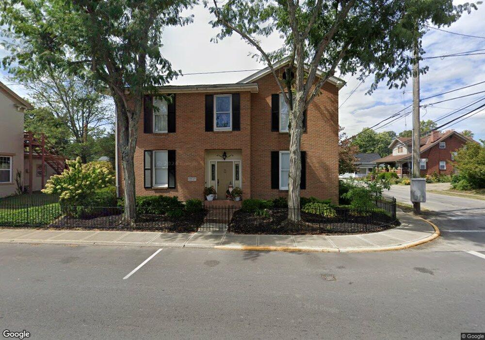
305 N Main St Georgetown, OH 45121
Estimated Value: $137,000 - $210,000
3
Beds
1
Bath
1,244
Sq Ft
$145/Sq Ft
Est. Value
About This Home
This home is located at 305 N Main St, Georgetown, OH 45121 and is currently estimated at $180,000, approximately $144 per square foot. 305 N Main St is a home located in Brown County with nearby schools including Georgetown Elementary School and Georgetown Jr/Sr High School.
Ownership History
Date
Name
Owned For
Owner Type
Purchase Details
Closed on
May 31, 2022
Sold by
John C And Elaine P Ludy Revocable Trust
Bought by
John C And Elaine P Ludy Marital Trust
Current Estimated Value
Purchase Details
Closed on
Apr 27, 2021
Sold by
Ludy Elaine P and Ludy John C
Bought by
Ludy John C and Ludy Elaine P
Purchase Details
Closed on
Apr 21, 2021
Sold by
Elaine P Ludy Revocable Trust and Ludy Elaine P
Bought by
John C And Elaine P Ludy Revocable Trust and Ludy
Purchase Details
Closed on
Apr 11, 1996
Sold by
Rose Mary J
Bought by
Ludy John C
Purchase Details
Closed on
Feb 11, 1994
Sold by
Gray Lisa A
Bought by
Gray Lisa A and Watson Geo
Create a Home Valuation Report for This Property
The Home Valuation Report is an in-depth analysis detailing your home's value as well as a comparison with similar homes in the area
Home Values in the Area
Average Home Value in this Area
Purchase History
| Date | Buyer | Sale Price | Title Company |
|---|---|---|---|
| John C And Elaine P Ludy Marital Trust | -- | None Listed On Document | |
| Ludy John C | -- | None Available | |
| John C And Elaine P Ludy Revocable Trust | -- | None Listed On Document | |
| Ludy John C | $32,500 | -- | |
| Gray Lisa A | $29,000 | -- |
Source: Public Records
Tax History
| Year | Tax Paid | Tax Assessment Tax Assessment Total Assessment is a certain percentage of the fair market value that is determined by local assessors to be the total taxable value of land and additions on the property. | Land | Improvement |
|---|---|---|---|---|
| 2024 | $1,028 | $28,350 | $3,150 | $25,200 |
| 2023 | $1,028 | $19,980 | $2,650 | $17,330 |
| 2022 | $788 | $19,980 | $2,650 | $17,330 |
| 2021 | $781 | $19,980 | $2,650 | $17,330 |
| 2020 | $690 | $16,650 | $2,210 | $14,440 |
| 2019 | $343 | $16,650 | $2,210 | $14,440 |
| 2018 | $681 | $16,650 | $2,210 | $14,440 |
| 2017 | $546 | $15,760 | $2,430 | $13,330 |
| 2016 | $546 | $15,760 | $2,430 | $13,330 |
| 2015 | $568 | $15,760 | $2,430 | $13,330 |
| 2014 | $568 | $15,540 | $2,210 | $13,330 |
| 2013 | $567 | $15,540 | $2,210 | $13,330 |
Source: Public Records
Map
Nearby Homes
- 405 N Main St
- 508 Mount Orab Pike
- 399 Elmwood Ct
- 406 E North St
- 60 New St
- 505 S Water St
- 510 W State St
- 427 Kenwood Ave
- 1 N Kenwood Ave
- 2 N Kenwood Ave
- 666 E State St
- 708 E State St
- 0 St Rt 221 & Footbridge Unit 1826509
- 155 Free Soil Rd
- 25 Douglas Ln
- 20 Heritage Hill Dr
- 175 Douglas Cir
- 38 Dell Acres Dr
- 470 Free Soil Rd
- 7480 Old Us Highway 68
- 305 N Main St
- 305 N Main St
- 310 N Main St
- 401 N Main St
- 300 N Main St
- 304 N Main St
- 108 N Pleasant St
- 405 N Main St Unit A
- 115 E Plum St
- 404 N Pleasant St
- 404 N Main St
- 108 E North St
- 305 N Pleasant St
- 201 N Main St
- 200 W North St
- 406 N Main St
- 204 N Pleasant St
- 301 N Pleasant St
- 203 W North St
- 108 E Plum St
Your Personal Tour Guide
Ask me questions while you tour the home.