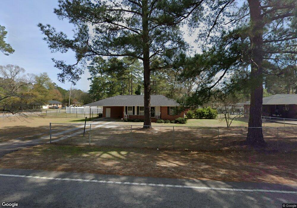
305 N Williamson Rd Florence, SC 29506
Glendale Acres NeighborhoodEstimated Value: $145,472 - $160,000
3
Beds
2
Baths
1,216
Sq Ft
$126/Sq Ft
Est. Value
About This Home
This home is located at 305 N Williamson Rd, Florence, SC 29506 and is currently estimated at $153,368, approximately $126 per square foot. 305 N Williamson Rd is a home located in Florence County with nearby schools including Theodore Lester Elementary School, Williams Middle School, and Wilson High School.
Ownership History
Date
Name
Owned For
Owner Type
Purchase Details
Closed on
Jul 13, 2005
Sold by
Request Properties Ii Llc
Bought by
Bradley Cecil and Bradley Alberta
Current Estimated Value
Home Financials for this Owner
Home Financials are based on the most recent Mortgage that was taken out on this home.
Original Mortgage
$17,000
Interest Rate
5.21%
Mortgage Type
Stand Alone Second
Purchase Details
Closed on
Aug 31, 2004
Sold by
Gum Roy F
Bought by
Request Properties Ii Llc
Create a Home Valuation Report for This Property
The Home Valuation Report is an in-depth analysis detailing your home's value as well as a comparison with similar homes in the area
Home Values in the Area
Average Home Value in this Area
Purchase History
| Date | Buyer | Sale Price | Title Company |
|---|---|---|---|
| Bradley Cecil | $85,000 | -- | |
| Request Properties Ii Llc | $56,000 | -- | |
| Gum Roy F | -- | -- |
Source: Public Records
Mortgage History
| Date | Status | Borrower | Loan Amount |
|---|---|---|---|
| Closed | Bradley Cecil | $17,000 | |
| Open | Bradley Cecil | $68,000 |
Source: Public Records
Tax History
| Year | Tax Paid | Tax Assessment Tax Assessment Total Assessment is a certain percentage of the fair market value that is determined by local assessors to be the total taxable value of land and additions on the property. | Land | Improvement |
|---|---|---|---|---|
| 2025 | $432 | $4,755 | $400 | $4,355 |
| 2024 | $541 | $4,755 | $400 | $4,355 |
| 2023 | $341 | $3,395 | $400 | $2,995 |
| 2022 | $502 | $3,395 | $400 | $2,995 |
| 2021 | $422 | $3,260 | $0 | $0 |
| 2020 | $460 | $3,260 | $0 | $0 |
| 2019 | $461 | $3,395 | $400 | $2,995 |
| 2018 | $413 | $3,260 | $0 | $0 |
| 2017 | $439 | $3,260 | $0 | $0 |
| 2016 | $346 | $3,260 | $0 | $0 |
| 2015 | $376 | $3,260 | $0 | $0 |
| 2014 | $320 | $3,395 | $400 | $2,995 |
Source: Public Records
Map
Nearby Homes
- 300 N Williamson Rd
- 3311 E Bennett Dr
- 410 N Salem Dr
- 132 State Road S-21-898
- 454 E Glendale Dr
- 200 Hudson Dr
- 3501 E Winlark Dr
- 3086 Cobblestone St
- 2797 Leola Hill Dr
- 2635 E Palmetto St
- 3260 Cedar Creek Ln
- 3264 Cedar Creek Ln
- 3256 Cedar Creek Ln
- 3249 Winding Way
- 3237 Winding Way Dr
- TBD S Wallace Rd
- 226 Drizzy Dr
- 227 Drizzy Dr
- 231 Drizzy Dr
- 229 Drizzy Dr
- 303 N Williamson Rd
- 3201 E Linda Dr
- 3214 E Bennett Dr
- 3205 E Bennett Dr
- 3215 E Linda Dr
- 3200 E Linda Dr
- 3207 E Bennett Dr
- 3303 E Linda Dr
- 3306 E Bennett Dr
- 250 N Williamson Rd
- 3209 E Bennett Dr
- 3210 E Linda Dr
- 3309 E Linda Dr
- 3105 E Sammys Ln
- 248 N Williamson Rd
- 350 N Williamson Rd
- 3301 E Bennett Dr
- 3214 E Linda Dr
- 3170 Tall Oaks Dr
- 3108 E Sammys Ln
Your Personal Tour Guide
Ask me questions while you tour the home.