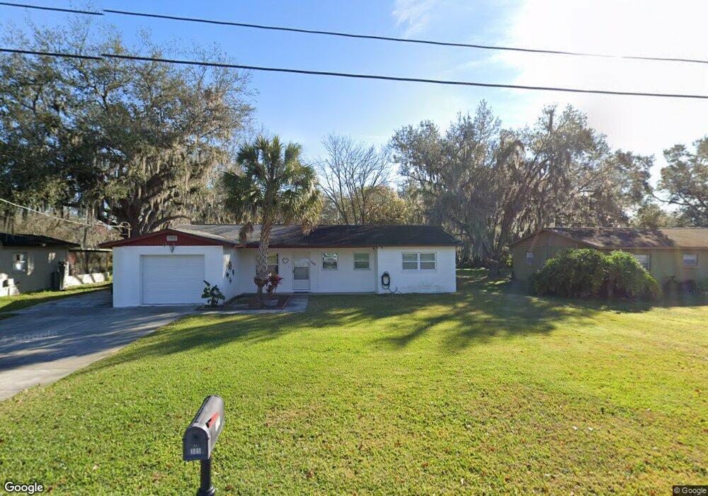
305 NE 5th Ave Mulberry, FL 33860
Estimated Value: $229,692 - $243,000
3
Beds
2
Baths
1,268
Sq Ft
$185/Sq Ft
Est. Value
About This Home
This home is located at 305 NE 5th Ave, Mulberry, FL 33860 and is currently estimated at $235,173, approximately $185 per square foot. 305 NE 5th Ave is a home located in Polk County with nearby schools including Purcell Elementary School, Bartow Elementary Academy, and Mulberry Middle School.
Ownership History
Date
Name
Owned For
Owner Type
Purchase Details
Closed on
Jan 16, 2025
Sold by
Resmondo Ann L
Bought by
Resmondo Ann L and Hooks Scott Thomas
Current Estimated Value
Purchase Details
Closed on
Apr 7, 2015
Sold by
Resmondo George A and Resmondo Ann L
Bought by
Resmondo George A and Resmondo Ann L
Purchase Details
Closed on
May 16, 1994
Sold by
Assoc Finl
Bought by
Resmondo George Anthony
Home Financials for this Owner
Home Financials are based on the most recent Mortgage that was taken out on this home.
Original Mortgage
$26,100
Interest Rate
8.52%
Create a Home Valuation Report for This Property
The Home Valuation Report is an in-depth analysis detailing your home's value as well as a comparison with similar homes in the area
Home Values in the Area
Average Home Value in this Area
Purchase History
| Date | Buyer | Sale Price | Title Company |
|---|---|---|---|
| Resmondo Ann L | -- | None Listed On Document | |
| Resmondo Ann L | -- | None Listed On Document | |
| Resmondo George A | -- | None Available | |
| Resmondo George Anthony | $29,000 | -- |
Source: Public Records
Mortgage History
| Date | Status | Borrower | Loan Amount |
|---|---|---|---|
| Previous Owner | Resmondo George Anthony | $26,100 |
Source: Public Records
Tax History
| Year | Tax Paid | Tax Assessment Tax Assessment Total Assessment is a certain percentage of the fair market value that is determined by local assessors to be the total taxable value of land and additions on the property. | Land | Improvement |
|---|---|---|---|---|
| 2025 | $333 | $59,903 | -- | -- |
| 2024 | $419 | $58,215 | -- | -- |
| 2023 | $419 | $56,519 | $0 | $0 |
| 2022 | $802 | $54,873 | $0 | $0 |
| 2021 | $795 | $53,275 | $0 | $0 |
| 2020 | $782 | $52,539 | $0 | $0 |
| 2018 | $745 | $50,400 | $0 | $0 |
| 2017 | $731 | $49,363 | $0 | $0 |
| 2016 | $726 | $48,348 | $0 | $0 |
Source: Public Records
Map
Nearby Homes
- 109 NE 4th Ave
- 202 E Badcock Blvd
- 111 NE 1st Ave
- 1002 NE 1st St
- 1001 NE 1st St
- 1107 NE 5th St
- 600 SE 3rd St
- 503 NW 1st Ave Unit A & B
- 1119 Aruba Ave
- 1211 NE 4th St
- 602 NW 1st Ave
- 102 NE 9th St
- 1306 NE 3rd St
- 1056 Aruba Ave
- 707 NW 2nd Ave
- 404 NW 7th St
- 208 SW 3rd Ave
- 406 NW 7th St
- 407 NW 8th St
- 610 NW Phosphate Blvd