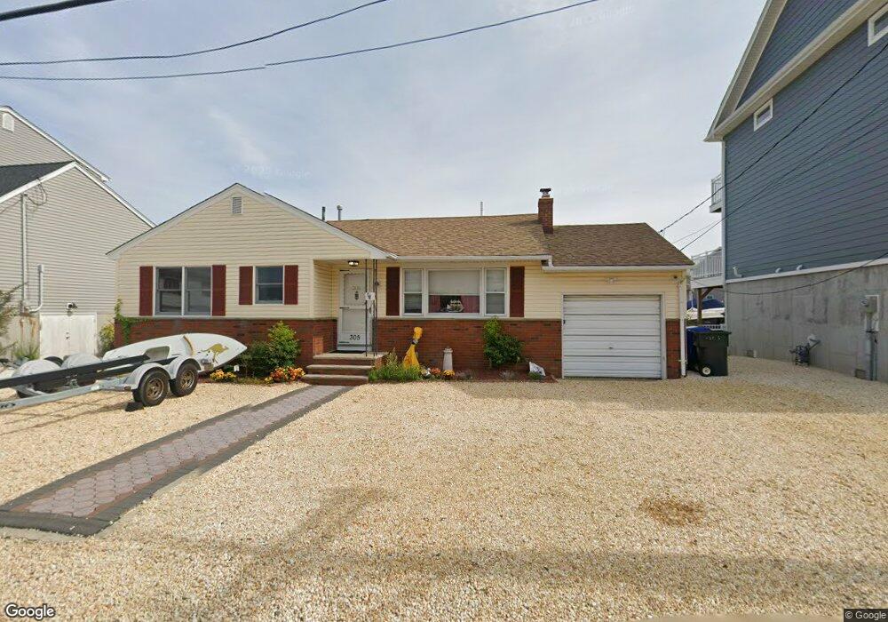
305 Ormond Dr Lavallette, NJ 08735
Dover Beaches North NeighborhoodEstimated Value: $1,017,253 - $1,220,000
3
Beds
1
Bath
1,034
Sq Ft
$1,107/Sq Ft
Est. Value
About This Home
This home is located at 305 Ormond Dr, Lavallette, NJ 08735 and is currently estimated at $1,144,313, approximately $1,106 per square foot. 305 Ormond Dr is a home located in Ocean County.
Ownership History
Date
Name
Owned For
Owner Type
Purchase Details
Closed on
Feb 7, 2023
Sold by
Krehel Keith
Bought by
Moyes James
Current Estimated Value
Purchase Details
Closed on
Sep 4, 2007
Sold by
Munn Roger F and Roeben Genevieve C
Bought by
Moyes Kenneth
Home Financials for this Owner
Home Financials are based on the most recent Mortgage that was taken out on this home.
Original Mortgage
$560,000
Interest Rate
6.25%
Mortgage Type
Purchase Money Mortgage
Purchase Details
Closed on
Jul 12, 2004
Sold by
Munn Ruth M
Bought by
Munn Ruth M
Create a Home Valuation Report for This Property
The Home Valuation Report is an in-depth analysis detailing your home's value as well as a comparison with similar homes in the area
Home Values in the Area
Average Home Value in this Area
Purchase History
| Date | Buyer | Sale Price | Title Company |
|---|---|---|---|
| Moyes James | $760,000 | None Listed On Document | |
| Moyes James | $760,000 | None Listed On Document | |
| Moyes Kenneth | $700,000 | None Available | |
| Munn Ruth M | -- | -- |
Source: Public Records
Mortgage History
| Date | Status | Borrower | Loan Amount |
|---|---|---|---|
| Previous Owner | Moyes Kenneth | $560,000 |
Source: Public Records
Tax History
| Year | Tax Paid | Tax Assessment Tax Assessment Total Assessment is a certain percentage of the fair market value that is determined by local assessors to be the total taxable value of land and additions on the property. | Land | Improvement |
|---|---|---|---|---|
| 2025 | $12,470 | $638,200 | $490,000 | $148,200 |
| 2024 | $11,047 | $638,200 | $490,000 | $148,200 |
| 2023 | $10,652 | $638,200 | $490,000 | $148,200 |
| 2022 | $10,652 | $638,200 | $490,000 | $148,200 |
| 2021 | $10,298 | $411,100 | $334,800 | $76,300 |
| 2020 | $10,253 | $411,100 | $334,800 | $76,300 |
| 2019 | $9,809 | $411,100 | $334,800 | $76,300 |
| 2018 | $9,677 | $411,100 | $334,800 | $76,300 |
| 2017 | $9,595 | $411,100 | $334,800 | $76,300 |
| 2016 | $9,344 | $411,100 | $334,800 | $76,300 |
| 2015 | $8,991 | $411,100 | $334,800 | $76,300 |
| 2014 | $7,129 | $342,400 | $334,800 | $7,600 |
Source: Public Records
Map
Nearby Homes
- 459 Boca Raton Dr
- 417 Delray Dr
- 359 Naples Ct
- 354 Naples Ct
- 348 Venice Dr
- 351 W Bayview Dr
- 170 W Beach Way
- 109 W Tarpon Way
- 155 W Atlantic Way
- 111 W Marlin Way
- 254 Harbor Ct
- 53 E Bay Way
- 100 3rd Ave
- 201 5th Ave
- 33 E Penguin Way
- 20 E Bonita Way
- 208 Mallard Ln
- 545 New Jersey 35
- 201 Mallard Ln
- 3201 Route 35 N Unit B
Your Personal Tour Guide
Ask me questions while you tour the home.