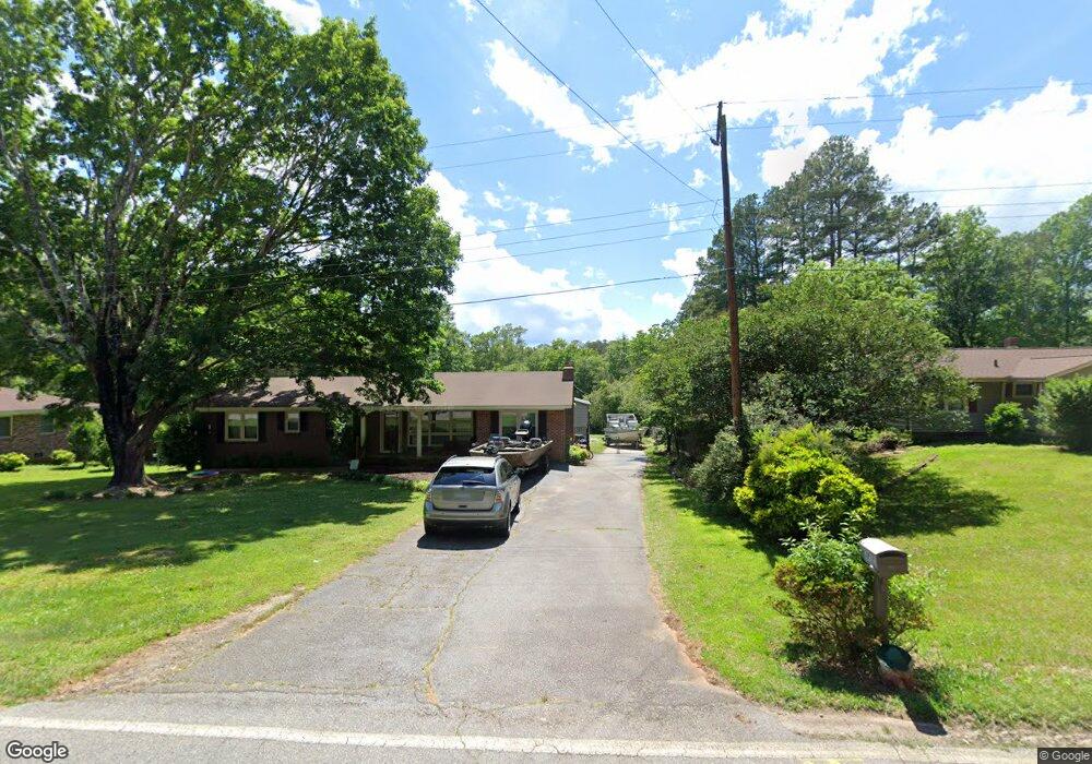
305 Playground Rd Walhalla, SC 29691
Estimated Value: $222,000 - $252,000
3
Beds
2
Baths
1,539
Sq Ft
$154/Sq Ft
Est. Value
About This Home
This home is located at 305 Playground Rd, Walhalla, SC 29691 and is currently estimated at $236,723, approximately $153 per square foot. 305 Playground Rd is a home located in Oconee County with nearby schools including Walhalla Elementary School, Walhalla Middle School, and Walhalla High School.
Ownership History
Date
Name
Owned For
Owner Type
Purchase Details
Closed on
Apr 19, 2018
Sold by
Robinson Ronald and Robinson Christa
Bought by
Holbrooks Joshua K
Current Estimated Value
Home Financials for this Owner
Home Financials are based on the most recent Mortgage that was taken out on this home.
Original Mortgage
$108,080
Outstanding Balance
$92,590
Interest Rate
4.46%
Mortgage Type
New Conventional
Estimated Equity
$144,133
Create a Home Valuation Report for This Property
The Home Valuation Report is an in-depth analysis detailing your home's value as well as a comparison with similar homes in the area
Home Values in the Area
Average Home Value in this Area
Purchase History
| Date | Buyer | Sale Price | Title Company |
|---|---|---|---|
| Holbrooks Joshua K | $107,000 | None Available |
Source: Public Records
Mortgage History
| Date | Status | Borrower | Loan Amount |
|---|---|---|---|
| Open | Holbrooks Joshua K | $108,080 |
Source: Public Records
Tax History
| Year | Tax Paid | Tax Assessment Tax Assessment Total Assessment is a certain percentage of the fair market value that is determined by local assessors to be the total taxable value of land and additions on the property. | Land | Improvement |
|---|---|---|---|---|
| 2025 | $845 | $4,381 | $585 | $3,796 |
| 2024 | $837 | $4,381 | $585 | $3,796 |
| 2023 | $821 | $4,381 | $585 | $3,796 |
| 2022 | $821 | $4,381 | $585 | $3,796 |
| 2021 | $1,552 | $4,222 | $585 | $3,637 |
| 2020 | $457 | $4,222 | $585 | $3,637 |
| 2019 | $457 | $0 | $0 | $0 |
| 2018 | $854 | $0 | $0 | $0 |
| 2017 | $1,552 | $0 | $0 | $0 |
| 2016 | $1,552 | $0 | $0 | $0 |
| 2015 | -- | $0 | $0 | $0 |
| 2014 | -- | $5,238 | $1,115 | $4,123 |
| 2013 | -- | $0 | $0 | $0 |
Source: Public Records
Map
Nearby Homes
- 101 Hazelwood Way
- 223 N Dogwood Dr
- 606 N Poplar St
- 00 Abbott Ln
- Tract B Bobolink Dr
- 00 N Church St
- 324 Fox Run Rd
- 221 Cub Cove Dr
- 00 Fox Run Rd
- 323 Fox Run Rd
- Lot 57 Fox Run Rd
- 147 White Oak St
- 804 W North Broad St
- 384 E Woodland Dr
- 606 W South Broad St
- 107 S Laurel St
- 109 S Laurel St
- 209 Moore Ave
- 807 W Main St
- 318 S Pine St
- 307 Playground Rd
- 303 Playground Rd
- 301 Playground Rd
- 309 Playground Rd
- 404 Holloway St
- 410 Holloway St
- 216 Malinda St
- 300 Playground Rd
- 416 Holloway St
- 204 Malinda St
- 422 Holloway St
- 211 Malinda St
- 403 Holloway St
- 214 Playground Rd
- 409 Holloway St
- 205 Malinda St
- 217 Malinda St
- 00 Earlestead Dr
- 401 Playground Rd
- 100 Hazelwood Way
Your Personal Tour Guide
Ask me questions while you tour the home.