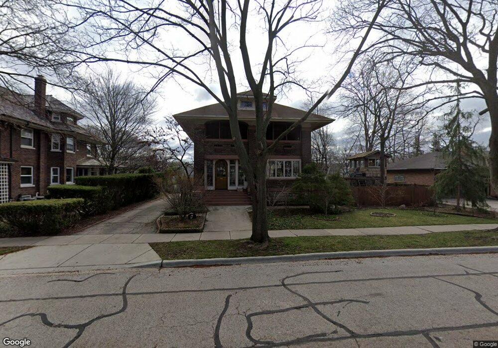
305 S 2nd St West Dundee, IL 60118
Estimated Value: $386,379 - $472,000
4
Beds
--
Bath
1,818
Sq Ft
$232/Sq Ft
Est. Value
About This Home
This home is located at 305 S 2nd St, West Dundee, IL 60118 and is currently estimated at $421,845, approximately $232 per square foot. 305 S 2nd St is a home located in Kane County with nearby schools including Dundee Highlands Elementary School, Dundee Middle School, and Dundee-Crown High School.
Ownership History
Date
Name
Owned For
Owner Type
Purchase Details
Closed on
Jan 27, 1999
Sold by
First American Bank
Bought by
Rader Robert D and Welter Mary C
Current Estimated Value
Home Financials for this Owner
Home Financials are based on the most recent Mortgage that was taken out on this home.
Original Mortgage
$197,200
Outstanding Balance
$46,716
Interest Rate
6.75%
Estimated Equity
$375,129
Purchase Details
Closed on
Nov 24, 1998
Sold by
Johnson Dinna L
Bought by
First American Bank and Trust #1-95-102
Home Financials for this Owner
Home Financials are based on the most recent Mortgage that was taken out on this home.
Original Mortgage
$185,000
Interest Rate
9.75%
Purchase Details
Closed on
Nov 16, 1998
Sold by
First American Bank
Bought by
Johnson Dinna L
Home Financials for this Owner
Home Financials are based on the most recent Mortgage that was taken out on this home.
Original Mortgage
$185,000
Interest Rate
9.75%
Purchase Details
Closed on
Jan 9, 1995
Sold by
Nbd Bank
Bought by
First American Bank
Create a Home Valuation Report for This Property
The Home Valuation Report is an in-depth analysis detailing your home's value as well as a comparison with similar homes in the area
Home Values in the Area
Average Home Value in this Area
Purchase History
| Date | Buyer | Sale Price | Title Company |
|---|---|---|---|
| Rader Robert D | $246,500 | Inter County Title Co | |
| First American Bank | -- | -- | |
| Johnson Dinna L | -- | Intercounty Title | |
| First American Bank | -- | -- |
Source: Public Records
Mortgage History
| Date | Status | Borrower | Loan Amount |
|---|---|---|---|
| Open | Rader Robert D | $197,200 | |
| Previous Owner | Johnson Dinna L | $185,000 |
Source: Public Records
Tax History Compared to Growth
Tax History
| Year | Tax Paid | Tax Assessment Tax Assessment Total Assessment is a certain percentage of the fair market value that is determined by local assessors to be the total taxable value of land and additions on the property. | Land | Improvement |
|---|---|---|---|---|
| 2024 | $8,917 | $125,399 | $20,394 | $105,005 |
| 2023 | $5,651 | $112,830 | $18,350 | $94,480 |
| 2022 | $7,280 | $93,633 | $18,350 | $75,283 |
| 2021 | $6,419 | $88,408 | $17,326 | $71,082 |
| 2020 | $6,455 | $86,420 | $16,936 | $69,484 |
| 2019 | $6,604 | $82,039 | $16,077 | $65,962 |
| 2018 | $7,189 | $86,374 | $15,759 | $70,615 |
| 2017 | $6,809 | $80,799 | $14,742 | $66,057 |
| 2016 | $7,436 | $78,233 | $14,274 | $63,959 |
| 2015 | -- | $76,861 | $19,493 | $57,368 |
| 2014 | -- | $74,739 | $18,955 | $55,784 |
| 2013 | -- | $77,026 | $19,535 | $57,491 |
Source: Public Records
Map
Nearby Homes
- 112 Liberty St
- 93 Liberty St
- 505 S 3rd St
- 516 S 1st St
- Lot 1 View St
- 512 Lisa Rd
- 560 S 5th St
- 7 King William St
- 436 Barrington Ave
- 4 Summit St
- 0000 Strom Dr
- 432 Illinois St
- 510 N Van Buren St
- 519 Oak Dr
- 152 King Ave
- 709 Timothy Ct Unit 171
- 849 Hemlock Dr
- 1042 Chateau Bluff Ln
- 152 Aberdeen Dr
- 1 S Lincoln Ave