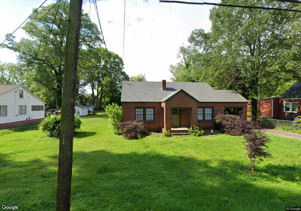
305 Sims St Carrollton, GA 30117
Estimated Value: $186,000 - $230,000
3
Beds
1
Bath
1,170
Sq Ft
$178/Sq Ft
Est. Value
About This Home
This home is located at 305 Sims St, Carrollton, GA 30117 and is currently estimated at $208,656, approximately $178 per square foot. 305 Sims St is a home located in Carroll County with nearby schools including Carrollton Elementary School, Carrollton Upper Elementary School, and Carrollton Middle School.
Ownership History
Date
Name
Owned For
Owner Type
Purchase Details
Closed on
Dec 13, 2022
Sold by
Patterson Martha
Bought by
Warren Nina and Warren James P
Current Estimated Value
Purchase Details
Closed on
Apr 22, 2014
Sold by
Patterson Martha
Bought by
Patterson Martha and Hembree Becky P
Purchase Details
Closed on
Aug 12, 2008
Sold by
Not Provided
Bought by
Patterson Martha Ann
Purchase Details
Closed on
Dec 1, 1983
Sold by
Howard W O
Bought by
Patterson Patterson B and Patterson Martha
Create a Home Valuation Report for This Property
The Home Valuation Report is an in-depth analysis detailing your home's value as well as a comparison with similar homes in the area
Home Values in the Area
Average Home Value in this Area
Purchase History
| Date | Buyer | Sale Price | Title Company |
|---|---|---|---|
| Warren Nina | $145,000 | -- | |
| Patterson Martha | -- | -- | |
| Patterson Martha Ann | -- | -- | |
| Patterson Patterson B | $37,500 | -- |
Source: Public Records
Tax History Compared to Growth
Tax History
| Year | Tax Paid | Tax Assessment Tax Assessment Total Assessment is a certain percentage of the fair market value that is determined by local assessors to be the total taxable value of land and additions on the property. | Land | Improvement |
|---|---|---|---|---|
| 2024 | $1,746 | $63,883 | $26,542 | $37,341 |
| 2023 | $1,746 | $60,719 | $26,542 | $34,177 |
| 2022 | $1,325 | $45,378 | $17,695 | $27,683 |
| 2021 | $1,083 | $37,092 | $13,107 | $23,985 |
| 2020 | $1,006 | $34,433 | $13,107 | $21,326 |
| 2019 | $971 | $32,923 | $13,107 | $19,816 |
| 2018 | $932 | $31,161 | $13,107 | $18,054 |
| 2017 | $938 | $31,161 | $13,107 | $18,054 |
| 2016 | $801 | $31,161 | $13,107 | $18,054 |
| 2015 | $740 | $23,944 | $8,000 | $15,944 |
| 2014 | $743 | $23,944 | $8,000 | $15,944 |
Source: Public Records
Map
Nearby Homes
- 201 Stewart St
- 120 Stewart St
- 119 Oxford Square
- 322 Cedar St
- 122 Mandeville Ave
- 541 N White St Unit 12
- 541 N White St
- 123 Autumn Glen Dr
- 777 College St
- 114 Green Point Way
- 123 Cedar Park Way
- 110 Town Walk Ln
- 325 Almon Rd
- 103 W Chandler St
- 0 Ward St Unit 10390499
- 205 Johnson Ave Unit 231
- 114 Bennett Cir
- 111 Lakeview Dr
- 108 Springwood Dr
- 301 C4 Bradley St
- 309 Sims St
- 301 Sims St
- 302 Sims St
- 315 Sims St
- 219 Sims St
- 314 Sims St
- 122 Perry St
- 105 Peachtree St
- 319 Sims St
- 218 Sims St
- 218 Sims St
- 0 Perry St Unit 8698739
- 0 Perry St Unit 8839731
- 0 Perry St Unit 8266133
- 0 Perry St Unit 8362798
- 0 Perry St Unit 8594209
- 0 Perry St
- 214 Sims St
- 118 Perry St
- 109 Peachtree St