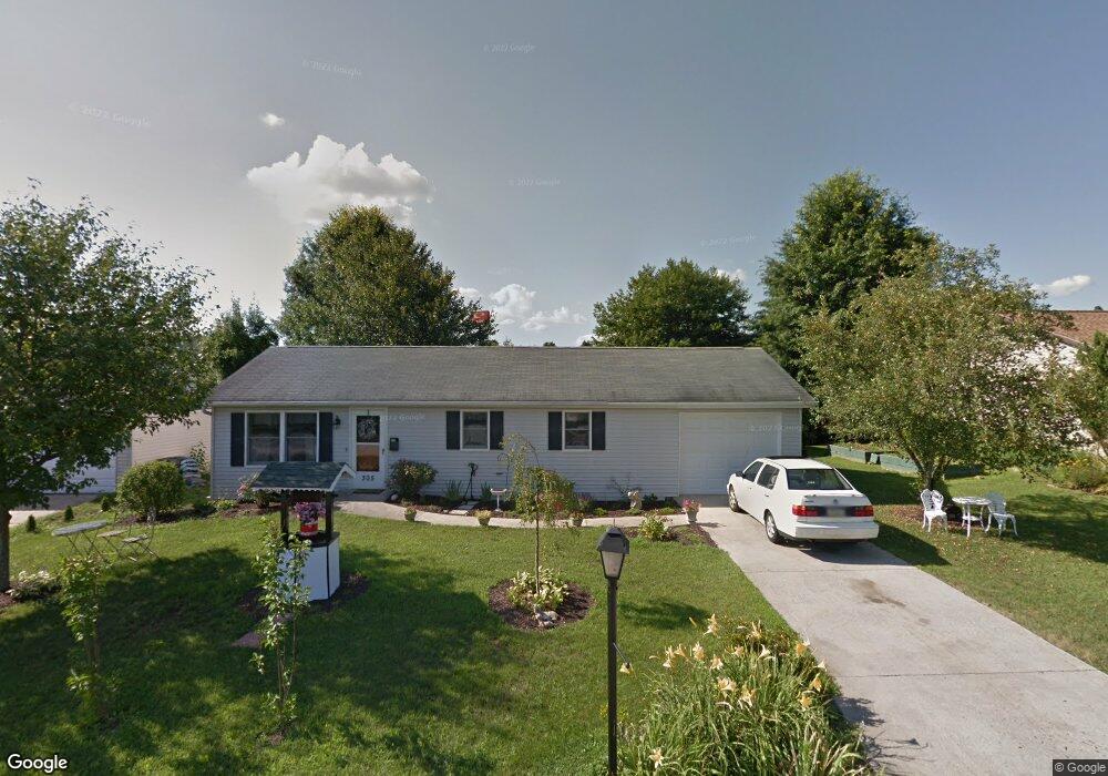
305 Tow Path Ln Pine Grove, PA 17963
Estimated Value: $168,000 - $203,000
2
Beds
2
Baths
960
Sq Ft
$191/Sq Ft
Est. Value
About This Home
This home is located at 305 Tow Path Ln, Pine Grove, PA 17963 and is currently estimated at $182,954, approximately $190 per square foot. 305 Tow Path Ln is a home located in Schuylkill County with nearby schools including Pine Grove Elementary School, Pine Grove Area Middle School, and Pine Grove Area High School.
Ownership History
Date
Name
Owned For
Owner Type
Purchase Details
Closed on
Nov 9, 2021
Sold by
Cooper Sr Brian K
Bought by
Cooper Brian K
Current Estimated Value
Home Financials for this Owner
Home Financials are based on the most recent Mortgage that was taken out on this home.
Original Mortgage
$69,000
Interest Rate
3.09%
Mortgage Type
New Conventional
Purchase Details
Closed on
Apr 30, 2018
Sold by
Snyder Kenneth A and Snyder Linda
Bought by
Cooper Briann K and Demarco Victoria
Home Financials for this Owner
Home Financials are based on the most recent Mortgage that was taken out on this home.
Original Mortgage
$68,000
Interest Rate
4.44%
Mortgage Type
New Conventional
Purchase Details
Closed on
May 31, 2006
Sold by
Bolton Catherine L
Bought by
Snyder Kenneth A
Purchase Details
Closed on
Apr 14, 2006
Sold by
Bolton Catherine L and Bolton June P
Bought by
Bolton Catherine L
Create a Home Valuation Report for This Property
The Home Valuation Report is an in-depth analysis detailing your home's value as well as a comparison with similar homes in the area
Home Values in the Area
Average Home Value in this Area
Purchase History
| Date | Buyer | Sale Price | Title Company |
|---|---|---|---|
| Cooper Brian K | -- | Res Title | |
| Cooper Briann K | $85,000 | None Available | |
| Snyder Kenneth A | $83,000 | None Available | |
| Bolton Catherine L | -- | None Available |
Source: Public Records
Mortgage History
| Date | Status | Borrower | Loan Amount |
|---|---|---|---|
| Previous Owner | Cooper Brian K | $69,000 | |
| Previous Owner | Cooper Briann K | $68,000 |
Source: Public Records
Tax History Compared to Growth
Tax History
| Year | Tax Paid | Tax Assessment Tax Assessment Total Assessment is a certain percentage of the fair market value that is determined by local assessors to be the total taxable value of land and additions on the property. | Land | Improvement |
|---|---|---|---|---|
| 2025 | $2,439 | $36,200 | $9,570 | $26,630 |
| 2024 | $2,213 | $36,200 | $9,570 | $26,630 |
| 2023 | $2,213 | $36,200 | $9,570 | $26,630 |
| 2022 | $2,213 | $36,200 | $9,570 | $26,630 |
| 2021 | $2,235 | $36,200 | $9,570 | $26,630 |
| 2020 | $2,235 | $36,200 | $9,570 | $26,630 |
| 2018 | $2,072 | $36,200 | $9,570 | $26,630 |
| 2017 | $1,950 | $36,200 | $9,570 | $26,630 |
| 2015 | -- | $36,200 | $9,570 | $26,630 |
| 2011 | -- | $36,200 | $0 | $0 |
Source: Public Records
Map
Nearby Homes
- 555 Honeysuckle Ct
- 848 Trestle Ct
- Lot 16 Beauty Mary Way
- Lot 17 Beauty Mary Way
- 1 Fidler Ct
- 6 Fidler Ct
- 40 Long Stretch Rd
- 70 Oak Grove Rd
- 14 Brookside Rd
- 2601 S Tulpehocken St
- 14 Ridge Vista Dr
- 16 Canal St
- 249 S Tulpehocken St
- 61 Mifflin St
- 38 Mifflin St
- 153 N Tulpehocken St
- 0 E Mill St
- 57 E Pottsville St
- 65 Mexico Rd
- 11 Hillside Dr