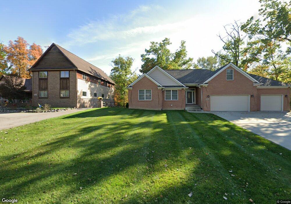
30569 Munger Dr Unit 9 Livonia, MI 48154
Estimated Value: $576,000 - $759,000
4
Beds
3
Baths
3,023
Sq Ft
$223/Sq Ft
Est. Value
About This Home
This home is located at 30569 Munger Dr Unit 9, Livonia, MI 48154 and is currently estimated at $673,268, approximately $222 per square foot. 30569 Munger Dr Unit 9 is a home located in Wayne County with nearby schools including Riley Upper Elementary School, Buchanan Elementary School, and Holmes Middle School.
Ownership History
Date
Name
Owned For
Owner Type
Purchase Details
Closed on
Oct 15, 2007
Sold by
Leventis Thomas J and Leventis Lynda M
Bought by
Miller Steve T
Current Estimated Value
Purchase Details
Closed on
Dec 7, 2001
Sold by
Ivezaj Draginja
Bought by
Leventis Lynda M
Home Financials for this Owner
Home Financials are based on the most recent Mortgage that was taken out on this home.
Original Mortgage
$70,000
Interest Rate
7.03%
Mortgage Type
Purchase Money Mortgage
Create a Home Valuation Report for This Property
The Home Valuation Report is an in-depth analysis detailing your home's value as well as a comparison with similar homes in the area
Home Values in the Area
Average Home Value in this Area
Purchase History
| Date | Buyer | Sale Price | Title Company |
|---|---|---|---|
| Miller Steve T | $435,000 | Multiple | |
| Leventis Lynda M | $55,000 | -- |
Source: Public Records
Mortgage History
| Date | Status | Borrower | Loan Amount |
|---|---|---|---|
| Previous Owner | Leventis Lynda M | $70,000 |
Source: Public Records
Tax History Compared to Growth
Tax History
| Year | Tax Paid | Tax Assessment Tax Assessment Total Assessment is a certain percentage of the fair market value that is determined by local assessors to be the total taxable value of land and additions on the property. | Land | Improvement |
|---|---|---|---|---|
| 2025 | $4,719 | $290,100 | $0 | $0 |
| 2024 | $4,719 | $284,900 | $0 | $0 |
| 2023 | $4,502 | $267,700 | $0 | $0 |
| 2022 | $7,977 | $244,400 | $0 | $0 |
| 2021 | $7,756 | $230,800 | $0 | $0 |
| 2019 | $7,453 | $229,200 | $0 | $0 |
| 2018 | $3,806 | $205,800 | $0 | $0 |
| 2017 | $975 | $200,700 | $0 | $0 |
| 2016 | $6,892 | $191,000 | $0 | $0 |
| 2015 | $16,493 | $184,420 | $0 | $0 |
| 2012 | -- | $156,050 | $30,290 | $125,760 |
Source: Public Records
Map
Nearby Homes
- 30425 Munger Dr
- 30115 Munger Dr
- 29945 6 Mile Rd
- 31069 Munger Dr
- 29836 Bobrich St
- 31366 Mayville St
- 31005 Roycroft St
- 15608 Hidden Ln
- 15345 Bainbridge St
- 15600 Auburndale St
- 18659 Flamingo Blvd
- 18725 Flamingo Blvd
- 29721 Pickford St
- 29106 Broadmoor St
- 18872 Hillcrest St
- 32525 6 Mile Rd
- 16966 Fairfield St
- 29760 Hoy St
- 29560 Clarita St Unit 11
- 30285 7 Mile Rd
- 30533 6 Mile Rd
- 30523 Munger Dr Unit 7
- 30507 Munger Dr
- 30507 Munger Dr
- 30473 Munger Dr Unit 4
- 30551 Munger Dr
- 30551 Munger Dr
- 16874 Ryan Rd
- 16852 Ryan Rd
- 16896 Ryan Rd
- 30572 Munger St
- 16830 Ryan Rd
- 30655 6 Mile Rd
- 30536 Munger Dr
- 30554 Munger St Unit 11
- 16808 Ryan Rd
- 30508 Munger St
- 16928 Ryan Rd
- 16776 Ryan Rd
- 30503 6 Mile Rd