
Seller's Agent in 2024
Heather Morris
SKOGMAN REALTY
(319) 366-6427
79 in this area
425 Total Sales


Estimated Value: $71,000 - $331,000
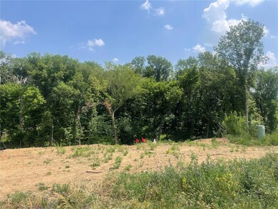
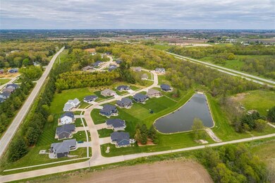
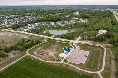
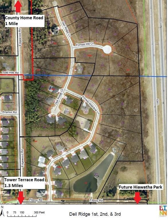
LOT 12, WOODED BUILDING SITE WITH 1.41 ACRES AND WALK OUT GRADE. DELL RIDGE COMMUNITY OFFERS A 3.72 ACRE FISHING POND WITH WALKING TRAIL ACCESS. COUNTRY SETTING WITH CITY AMENITIES. YOU MAY SELECT YOUR BUILDER. MINIMUM ABOVE GRADE SQUARE FEET REQUIREMENT 1,600 RANCH, 1,800 MULTI LEVEL, 2,000 TWO STORY. DELL RIDGE IS 1 MILE NORTH OF OF TOWER TERRACE AND 1.3 MILES SOUTH OF COUNTY HOME ROAD. EASY ACCESS TO I-380 INTERCHANGE. SERVICED BY MID AMERICAN ENERGY, REC ELECTRIC AND MEDIACOM. YEARLY $125 HOMEOWNERS ASSOCIATION FEE IS TO MAINTAIN THE POND (STOCKED WITH FISH), PLANTINGS SURROUNDING THE POND, ACCESS TRAIL, INSURANCE. PARCEL NUMBER 111912601800000. TOWER TERRACE, N ON EDGEWOOD ROAD, EAST ON FITZROY, NORTH ON FORREST MEADOW LANE TO FORREST HILL COURT. SERVICED BY MID AMERICAN ENERGY AND LINN COUNTY REC. HIAWATHA TURTLE CREEK PARK -18 ACRES INCLUDING 2 SOCCER FIELDS AND WALKING TRAIL LOCATED AT FITZROY DEAD END.
| Date | Buyer | Sale Price | Title Company |
|---|---|---|---|
| Stewart Shekeria | $23,500 | None Listed On Document | |
| Stewart Shekeria | $23,500 | None Listed On Document |
| Date | Event | Price | List to Sale | Price per Sq Ft |
|---|---|---|---|---|
| 07/18/2024 07/18/24 | Sold | $23,500 | -21.4% | -- |
| 07/08/2024 07/08/24 | Pending | -- | -- | -- |
| 06/25/2024 06/25/24 | Price Changed | $29,900 | -25.1% | -- |
| 10/05/2023 10/05/23 | Price Changed | $39,900 | -20.2% | -- |
| 06/22/2023 06/22/23 | Price Changed | $50,000 | +25.2% | -- |
| 10/04/2022 10/04/22 | Price Changed | $39,950 | -18.5% | -- |
| 08/01/2022 08/01/22 | For Sale | $49,000 | -- | -- |
| Year | Tax Paid | Tax Assessment Tax Assessment Total Assessment is a certain percentage of the fair market value that is determined by local assessors to be the total taxable value of land and additions on the property. | Land | Improvement |
|---|---|---|---|---|
| 2025 | $1,186 | $69,700 | $69,700 | -- |
| 2024 | $352 | $69,700 | $69,700 | -- |
| 2023 | $352 | $69,700 | $69,700 | $0 |
| 2022 | $35,200 | $17,200 | $17,200 | $0 |
| 2021 | $348 | $17,200 | $17,200 | $0 |
| 2020 | $368 | $17,200 | $17,200 | $0 |
| 2019 | $574 | $0 | $0 | $0 |
| 2018 | $0 | $0 | $0 | $0 |
Seller's Agent in 2024
Heather Morris
SKOGMAN REALTY
(319) 366-6427
79 in this area
425 Total Sales
D
Buyer's Agent in 2024
Dawson Walker
SKOGMAN REALTY
(319) 213-3116
1 in this area
1 Total Sale
Source: Cedar Rapids Area Association of REALTORS®
MLS Number: 2207529
APN: 11184-52008-00000
Disclaimer: Certain information contained herein is derived from information provided by parties other than Homes.com. All information provided is deemed reliable, but is not guaranteed to be accurate and should be independently verified.
![]() IDX information is provided exclusively for personal, non-commercial use, and may not be used for any purpose other than to identify prospective properties consumers may be interested in purchasing.
IDX information is provided exclusively for personal, non-commercial use, and may not be used for any purpose other than to identify prospective properties consumers may be interested in purchasing.
Information is deemed reliable but not guaranteed.