Estimated Value: $166,000 - $291,000
4
Beds
2
Baths
1,940
Sq Ft
$127/Sq Ft
Est. Value
About This Home
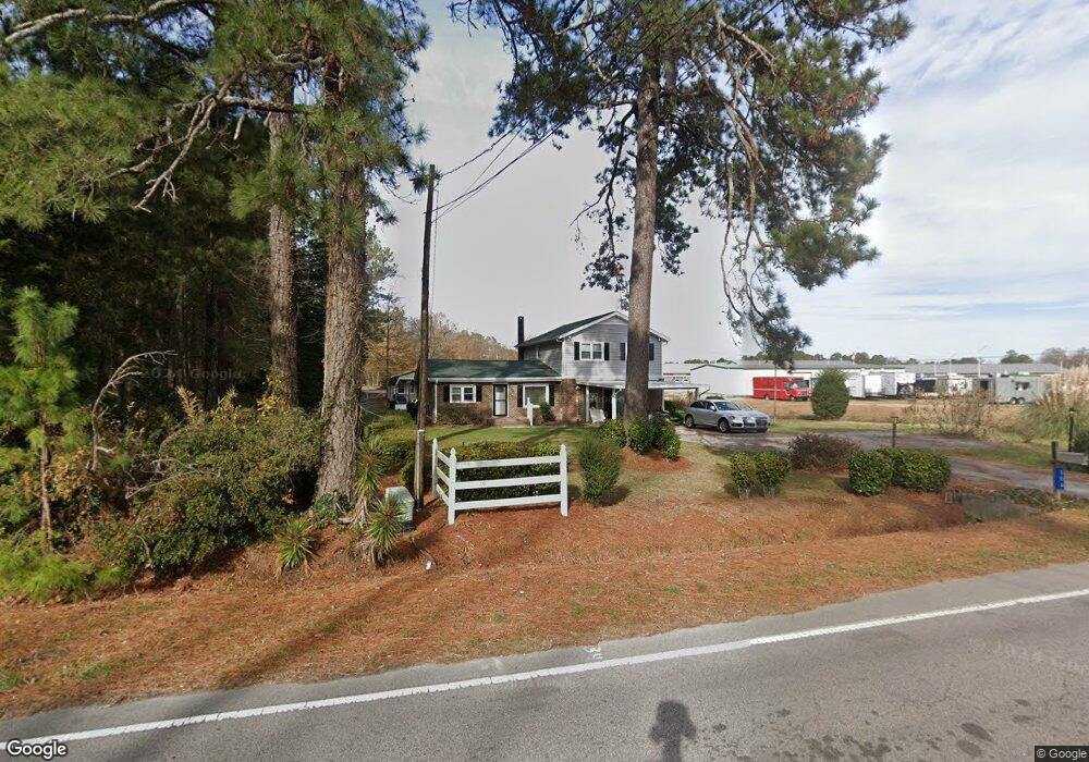
This home is located at 306 Us Highway 301 S, Selma, NC 27576 and is currently estimated at $246,100, approximately $126 per square foot. 306 Us Highway 301 S is a home with nearby schools including Micro Elementary School, North Johnston Middle School, and North Johnston High School.
Ownership History
Date
Name
Owned For
Owner Type
Purchase Details
Closed on
Jun 3, 2022
Sold by
Williams Jr Bennie L
Bought by
Smith Thaddeus Byron and Smith Laurie A
Current Estimated Value
Home Financials for this Owner
Home Financials are based on the most recent Mortgage that was taken out on this home.
Original Mortgage
$106,400
Outstanding Balance
$100,767
Interest Rate
4.75%
Mortgage Type
Balloon
Estimated Equity
$145,333
Create a Home Valuation Report for This Property
The Home Valuation Report is an in-depth analysis detailing your home's value as well as a comparison with similar homes in the area
Home Values in the Area
Average Home Value in this Area
Purchase History
| Date | Buyer | Sale Price | Title Company |
|---|---|---|---|
| Smith Thaddeus Byron | $112,000 | None Listed On Document |
Source: Public Records
Mortgage History
| Date | Status | Borrower | Loan Amount |
|---|---|---|---|
| Open | Smith Thaddeus Byron | $106,400 |
Source: Public Records
Tax History Compared to Growth
Tax History
| Year | Tax Paid | Tax Assessment Tax Assessment Total Assessment is a certain percentage of the fair market value that is determined by local assessors to be the total taxable value of land and additions on the property. | Land | Improvement |
|---|---|---|---|---|
| 2025 | $1,743 | $191,520 | $29,600 | $161,920 |
| 2024 | $1,516 | $117,490 | $17,250 | $100,240 |
| 2023 | $1,539 | $117,490 | $17,250 | $100,240 |
| 2022 | $1,523 | $112,790 | $17,250 | $95,540 |
| 2021 | $1,466 | $112,790 | $17,250 | $95,540 |
| 2020 | $1,478 | $112,790 | $17,250 | $95,540 |
| 2019 | $1,478 | $112,790 | $17,250 | $95,540 |
| 2018 | $1,352 | $101,660 | $16,280 | $85,380 |
| 2017 | $1,352 | $101,660 | $16,280 | $85,380 |
| 2016 | $1,352 | $101,660 | $16,280 | $85,380 |
| 2015 | $1,352 | $101,660 | $16,280 | $85,380 |
| 2014 | $1,352 | $101,660 | $16,280 | $85,380 |
Source: Public Records
Map
Nearby Homes
- 0 R St Unit 10062482
- 112 E Main St
- 306 W Main St
- 201 N Us 301
- 110 Dwight Dr
- 0 W Wilson St
- 509 W Main St
- 1829 Old Batten Rd
- 1101 Oak Grove Inn Rd
- 1216 Browns Dairy Rd
- 0 Old Creech Rd
- 241 Maxwell Farm Ln
- 215 Maxwell Farm Ln
- 103 Maxwell Farm Ln
- 61 Maxwell Farm Ln
- 73 Laramie Ln
- 242 Maxwell Farm Ln
- 210 Maxwell Farm Ln
- 132 Ewing Dr
- 173 Watson Rd
- 4660 U S 301
- 4570 Us Highway 301 N
- 301 Us Highway 301 S
- 4663 Us Hwy 301 N
- 204 U S 301
- 101 Fields St
- 204 S Smithfield St
- 204 301
- 101 Field St
- 204 Hwy 301
- 101 Fields St
- 203 S Railroad St
- 107 E Railroad St Unit B
- 107 E Railroad St
- 107 E Railroad St
- 107 E Railroad St Unit A
- 202 Highway 301 S
- 104 Fields St
- 102 Fields St
- 205 N Fayetteville St