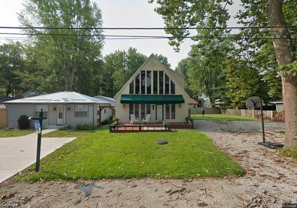
3069 Maple Ave NE Millersport, OH 43046
Estimated Value: $300,000 - $545,000
3
Beds
2
Baths
1,404
Sq Ft
$286/Sq Ft
Est. Value
About This Home
This home is located at 3069 Maple Ave NE, Millersport, OH 43046 and is currently estimated at $401,539, approximately $285 per square foot. 3069 Maple Ave NE is a home located in Fairfield County with nearby schools including Millersport Elementary School and Millersport Jr/Sr High School.
Ownership History
Date
Name
Owned For
Owner Type
Purchase Details
Closed on
May 28, 1996
Sold by
Hugus James G
Bought by
Bell Walter C and Bell Virginia O
Current Estimated Value
Purchase Details
Closed on
Mar 15, 1995
Sold by
Five J Dev Co 1
Bought by
Hugus James G and Hugus Joana M
Purchase Details
Closed on
Jan 21, 1993
Bought by
Wilhelm Jay A Trustee
Purchase Details
Closed on
May 1, 1990
Create a Home Valuation Report for This Property
The Home Valuation Report is an in-depth analysis detailing your home's value as well as a comparison with similar homes in the area
Home Values in the Area
Average Home Value in this Area
Purchase History
| Date | Buyer | Sale Price | Title Company |
|---|---|---|---|
| Bell Walter C | $169,900 | -- | |
| Hugus James G | $5,000 | -- | |
| Wilhelm Jay A Trustee | -- | -- | |
| -- | $90,000 | -- |
Source: Public Records
Tax History Compared to Growth
Tax History
| Year | Tax Paid | Tax Assessment Tax Assessment Total Assessment is a certain percentage of the fair market value that is determined by local assessors to be the total taxable value of land and additions on the property. | Land | Improvement |
|---|---|---|---|---|
| 2024 | $4,218 | $70,190 | $12,880 | $57,310 |
| 2023 | $2,773 | $70,190 | $12,880 | $57,310 |
| 2022 | $2,849 | $70,190 | $12,880 | $57,310 |
| 2021 | $2,303 | $51,090 | $12,880 | $38,210 |
| 2020 | $2,311 | $51,090 | $12,880 | $38,210 |
| 2019 | $2,312 | $51,090 | $12,880 | $38,210 |
| 2018 | $2,094 | $41,880 | $12,240 | $29,640 |
| 2017 | $2,095 | $41,880 | $12,240 | $29,640 |
| 2016 | $1,933 | $41,880 | $12,240 | $29,640 |
| 2015 | $1,903 | $40,560 | $12,240 | $28,320 |
| 2014 | $1,544 | $40,560 | $12,240 | $28,320 |
| 2013 | $1,544 | $40,560 | $12,240 | $28,320 |
Source: Public Records
Map
Nearby Homes
- 12946 W Bank Dr NE
- 12656 W Bank Dr NE
- 12580 W Bank Dr NE
- 12700 Onion Island NE
- 13180 W Bank Dr NE
- 12291 Ohio Ave
- 2486 Mallard Point Ln
- 13244 W Bank Dr NE
- 12055 7th Ave
- 2592 Summit St
- 3621 S Bank Rd NE
- 2582 E Park St
- 3317 S Bank Rd NE
- 3333 S Bank Rd NE
- 13404 W Bank Dr NE
- 3427 S Bank Rd NE
- 2595 Canal Dr
- 13474 W Bank Dr NE
- 2485 Mallard Point Ln
- 2484 Mallard Point Ln
- 3061 Maple Ave
- 3077 Maple Ave NE
- 3085 Maple Ave NE
- 3053 Maple Ave NE
- 3070 Cottonwood Ct NE
- 3093 Maple Ave NE
- 3045 Maple Ave NE
- 3062 Cottonwood Ct NE
- 3062 Cottonwood Ct
- 3102 Cottonwood Ct NE
- 0 Maple Ave
- 0 NE Maple Ave Unit 9819012
- 0 NE Maple Ave Unit 223001891
- 0 NE Maple Ave Unit Lot 39 2844016
- 3068 Maple Ave NE
- 3076 Maple Ave NE
- 3060 Maple Ave NE
- 3052 Maple Ave NE
- 3092 Maple Ave NE
- 3029 Maple Ave NE