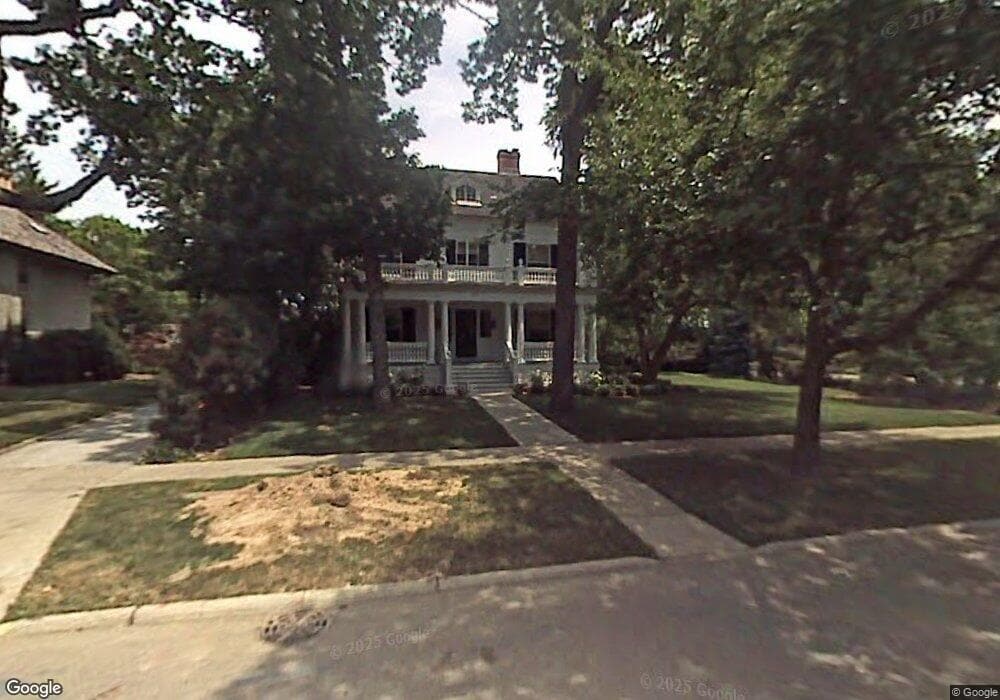
307 Abbotsford Rd Kenilworth, IL 60043
Estimated Value: $2,305,832 - $2,452,000
5
Beds
5
Baths
3,052
Sq Ft
$784/Sq Ft
Est. Value
About This Home
This home is located at 307 Abbotsford Rd, Kenilworth, IL 60043 and is currently estimated at $2,391,944, approximately $783 per square foot. 307 Abbotsford Rd is a home located in Cook County with nearby schools including The Joseph Sears School, New Trier Township High School, and New Trier Township High School - Northfield.
Ownership History
Date
Name
Owned For
Owner Type
Purchase Details
Closed on
Apr 10, 2017
Sold by
Armour Hollister S
Bought by
Arment Daniel and Collishaw Julie Anne
Current Estimated Value
Home Financials for this Owner
Home Financials are based on the most recent Mortgage that was taken out on this home.
Original Mortgage
$992,500
Outstanding Balance
$818,107
Interest Rate
3.87%
Mortgage Type
New Conventional
Estimated Equity
$1,573,837
Purchase Details
Closed on
Apr 7, 2010
Sold by
Rb Resolution Properties Llc Sienna Seri
Bought by
Armour Family Trust
Purchase Details
Closed on
Mar 5, 2004
Sold by
Armour Timothy K and Armour Hollister Steel
Bought by
Armour Hollister S and Hollister S Armour 1999 Trust
Home Financials for this Owner
Home Financials are based on the most recent Mortgage that was taken out on this home.
Original Mortgage
$619,000
Interest Rate
4.62%
Mortgage Type
Unknown
Create a Home Valuation Report for This Property
The Home Valuation Report is an in-depth analysis detailing your home's value as well as a comparison with similar homes in the area
Home Values in the Area
Average Home Value in this Area
Purchase History
| Date | Buyer | Sale Price | Title Company |
|---|---|---|---|
| Arment Daniel | $1,850,000 | Chicago Title | |
| Armour Family Trust | $370,000 | Ticor | |
| Armour Hollister S | -- | Cti |
Source: Public Records
Mortgage History
| Date | Status | Borrower | Loan Amount |
|---|---|---|---|
| Open | Arment Daniel | $992,500 | |
| Previous Owner | Armour Hollister S | $619,000 |
Source: Public Records
Tax History Compared to Growth
Tax History
| Year | Tax Paid | Tax Assessment Tax Assessment Total Assessment is a certain percentage of the fair market value that is determined by local assessors to be the total taxable value of land and additions on the property. | Land | Improvement |
|---|---|---|---|---|
| 2024 | $38,787 | $154,223 | $52,500 | $101,723 |
| 2023 | $36,442 | $154,223 | $52,500 | $101,723 |
| 2022 | $36,442 | $154,223 | $52,500 | $101,723 |
| 2021 | $34,682 | $117,465 | $38,500 | $78,965 |
| 2020 | $33,642 | $117,465 | $38,500 | $78,965 |
| 2019 | $32,604 | $129,083 | $38,500 | $90,583 |
| 2018 | $27,945 | $108,451 | $33,250 | $75,201 |
| 2017 | $27,118 | $108,451 | $33,250 | $75,201 |
| 2016 | $32,062 | $136,047 | $33,250 | $102,797 |
| 2015 | $28,610 | $106,935 | $27,125 | $79,810 |
| 2014 | $37,053 | $142,216 | $27,125 | $115,091 |
| 2013 | $34,929 | $142,216 | $27,125 | $115,091 |
Source: Public Records
Map
Nearby Homes
- 330 Abbotsford Rd
- 517 Cumnor Rd
- 530 Essex Rd
- 141 Kenilworth Ave
- 1120 Chestnut Ave
- 527 Warwick Rd
- 507 Kenilworth Ave
- 528 Roslyn Rd
- 1416 Elmwood Ave
- 54 Kenilworth Ave
- 303 Sheridan Rd
- 643 Abbotsford Rd
- 1630 Sheridan Rd Unit 5K
- 1630 Sheridan Rd Unit 2F
- 1630 Sheridan Rd Unit 8K
- 1630 Sheridan Rd Unit 2N
- 1630 Sheridan Rd Unit 3C
- 1630 Sheridan Rd Unit 4M
- 1630 Sheridan Rd Unit 2J
- 901 Westerfield Dr
- 315 Abbotsford Rd
- 307 Woodstock Ave
- 322 Woodstock Ave
- 312 Essex Rd
- 326 Essex Rd
- 326 Essex Rd
- 325 Abbotsford Rd
- 306 Woodstock Ave
- 300 Abbotsford Rd
- 314 Abbotsford Rd
- 325 Oxford Rd
- 320 Abbotsford Rd
- 331 Abbotsford Rd
- 240 Essex Rd
- 330 Oxford Rd
- 344 Woodstock Ave
- 232 Essex Rd
- 326 Oxford Rd
- 337 Abbotsford Rd
- 303 Cumnor Rd