Estimated Value: $352,000 - $415,000
--
Bed
--
Bath
1,008
Sq Ft
$380/Sq Ft
Est. Value
About This Home
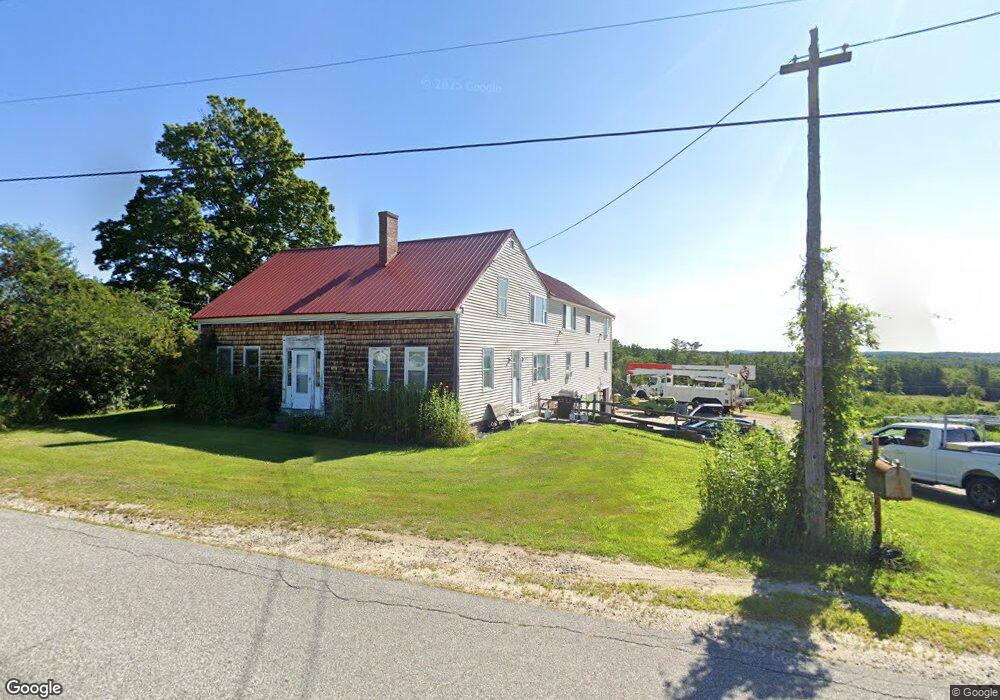
This home is located at 307 Center Minot Hill Rd, Minot, ME 04258 and is currently estimated at $382,607, approximately $379 per square foot. 307 Center Minot Hill Rd is a home located in Androscoggin County with nearby schools including Minot Consolidated School.
Ownership History
Date
Name
Owned For
Owner Type
Purchase Details
Closed on
Aug 10, 2015
Sold by
Gray Jane D and Tripp Dwight L
Bought by
Bridgham Harold W and Labonte Kelly A
Current Estimated Value
Home Financials for this Owner
Home Financials are based on the most recent Mortgage that was taken out on this home.
Original Mortgage
$100,000
Outstanding Balance
$78,649
Interest Rate
4.03%
Mortgage Type
New Conventional
Estimated Equity
$303,958
Create a Home Valuation Report for This Property
The Home Valuation Report is an in-depth analysis detailing your home's value as well as a comparison with similar homes in the area
Home Values in the Area
Average Home Value in this Area
Purchase History
| Date | Buyer | Sale Price | Title Company |
|---|---|---|---|
| Bridgham Harold W | -- | -- |
Source: Public Records
Mortgage History
| Date | Status | Borrower | Loan Amount |
|---|---|---|---|
| Open | Bridgham Harold W | $100,000 |
Source: Public Records
Tax History Compared to Growth
Tax History
| Year | Tax Paid | Tax Assessment Tax Assessment Total Assessment is a certain percentage of the fair market value that is determined by local assessors to be the total taxable value of land and additions on the property. | Land | Improvement |
|---|---|---|---|---|
| 2024 | $3,230 | $289,697 | $96,769 | $192,928 |
| 2023 | $2,894 | $289,398 | $96,470 | $192,928 |
| 2022 | $2,853 | $289,689 | $96,761 | $192,928 |
| 2021 | $2,660 | $160,746 | $59,125 | $101,621 |
| 2020 | $2,669 | $161,245 | $59,624 | $101,621 |
| 2019 | $2,686 | $169,451 | $67,830 | $101,621 |
| 2018 | $2,698 | $170,215 | $68,594 | $101,621 |
| 2017 | $2,665 | $169,721 | $68,100 | $101,621 |
| 2016 | $2,606 | $169,197 | $67,576 | $101,621 |
| 2015 | $2,599 | $166,623 | $65,002 | $101,621 |
| 2014 | $2,502 | $166,817 | $65,196 | $101,621 |
Source: Public Records
Map
Nearby Homes
- 355 Woodman Hill Rd
- 759 Lake St
- 351 W Auburn Rd
- 444 W Auburn Rd
- R03-007-A Pottle Hill Rd
- Lot 14C Mechanic Falls Rd
- 18 Concord Place Unit 24
- 88 Tourmaline Ln Unit 34
- 521 Stevens Mill Rd
- 1154 Hotel Rd
- lot 11 Minot Ave
- 4 Carson St
- 207 N Auburn Rd
- 14 Gammon Ave
- 867 Minot Ave
- 863 Minot Ave
- 69 Dawes Ave
- 13 Allen Ave
- 15 Linden St
- 60 Wedgewood Rd
- 314 Center Minot Hill Rd
- 340 Center Minot Hill Rd
- 347 Center Minot Hill Rd
- 354 Center Minot Hill Rd
- Lot 30D Cross Rd
- 65 Cross Rd
- 360 Center Minot Hill Rd
- 377 Center Minot Hill Rd
- 366 Center Minot Hill Rd
- 228 Center Minot Hill Rd
- 381 Center Minot Hill Rd
- 384 Center Minot Hill Rd
- 15 Old Trails Way
- 212 Center Minot Hill Rd
- 71 Cross Rd
- 0 Cross Rd
- 68 Cross Rd
- 25 Old Trails Way
- 194 Center Minot Hill Rd
- 177 Garfield Rd