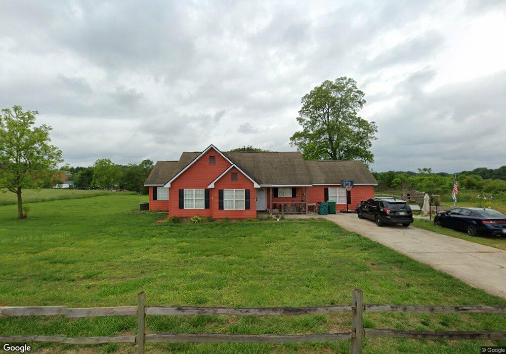
307 High Rd Carnesville, GA 30521
Estimated Value: $244,883 - $298,000
3
Beds
2
Baths
1,662
Sq Ft
$157/Sq Ft
Est. Value
About This Home
This home is located at 307 High Rd, Carnesville, GA 30521 and is currently estimated at $261,721, approximately $157 per square foot. 307 High Rd is a home located in Franklin County with nearby schools including Franklin County High School.
Ownership History
Date
Name
Owned For
Owner Type
Purchase Details
Closed on
Mar 15, 2024
Sold by
Clark Sandra Michele
Bought by
Clark Nicholas and Clark Sandra Michele
Current Estimated Value
Home Financials for this Owner
Home Financials are based on the most recent Mortgage that was taken out on this home.
Original Mortgage
$141,000
Outstanding Balance
$130,750
Interest Rate
5.9%
Mortgage Type
New Conventional
Estimated Equity
$130,971
Purchase Details
Closed on
May 4, 2005
Sold by
Bak Properties Llc
Bought by
Clark Nicholas and Clark Michele
Home Financials for this Owner
Home Financials are based on the most recent Mortgage that was taken out on this home.
Original Mortgage
$93,035
Interest Rate
5.88%
Mortgage Type
New Conventional
Purchase Details
Closed on
Feb 9, 2004
Sold by
Wiggley Robbie
Bought by
Bak Properties Llc
Purchase Details
Closed on
May 22, 2002
Sold by
Wright J B
Bought by
Canup Terry
Create a Home Valuation Report for This Property
The Home Valuation Report is an in-depth analysis detailing your home's value as well as a comparison with similar homes in the area
Purchase History
| Date | Buyer | Sale Price | Title Company |
|---|---|---|---|
| Clark Nicholas | -- | -- | |
| Clark Nicholas | $93,000 | -- | |
| Bak Properties Llc | $77,500 | -- | |
| Canup Terry | -- | -- |
Source: Public Records
Mortgage History
| Date | Status | Borrower | Loan Amount |
|---|---|---|---|
| Open | Clark Nicholas | $141,000 | |
| Previous Owner | Clark Nicholas | $93,035 |
Source: Public Records
Tax History
| Year | Tax Paid | Tax Assessment Tax Assessment Total Assessment is a certain percentage of the fair market value that is determined by local assessors to be the total taxable value of land and additions on the property. | Land | Improvement |
|---|---|---|---|---|
| 2025 | $1,542 | $68,746 | $10,000 | $58,746 |
| 2024 | $1,495 | $64,825 | $8,800 | $56,025 |
| 2023 | $1,489 | $59,732 | $8,800 | $50,932 |
| 2022 | $1,370 | $55,084 | $8,800 | $46,284 |
| 2021 | $1,261 | $47,830 | $6,000 | $41,830 |
| 2020 | $1,274 | $47,830 | $6,000 | $41,830 |
| 2019 | $1,231 | $47,830 | $6,000 | $41,830 |
| 2018 | $1,092 | $42,640 | $6,000 | $36,640 |
| 2017 | $987 | $37,328 | $6,000 | $31,328 |
| 2016 | $935 | $34,050 | $6,000 | $28,050 |
| 2015 | -- | $34,050 | $6,000 | $28,050 |
| 2014 | -- | $32,010 | $6,000 | $26,010 |
| 2013 | -- | $32,316 | $6,000 | $26,316 |
Source: Public Records
Map
Nearby Homes
- 2556 Turkey Creek Rd
- 555 Hubbard Rd
- 0 Turkey Creek Rd Unit 10671197
- 0 Turkey Creek Rd Unit 7709794
- 0 Turkey Creek Rd Unit 26024108
- 9750 Lavonia Rd
- 2985 Jackson Bridge Rd
- 183 Crest View Dr
- 7 Crest View Cir
- 365 Carroll Church Rd
- 160 Georgia 320
- 00 Hall Carson Rd
- 140 Summit Ln
- 5177 Sandy Cross Rd
- 5419 Georgia 320
- 1320 Burroughs Rd
- 5821 Georgia 320
- 16600 Highway 59
- 0 Baty Rd Unit 10562917
- 2565 New Franklin Church Rd
- 237 High Rd
- 533 High Rd
- 7151 Stone Bridge Rd
- 7130 Stone Bridge Rd
- 0 Stone Bridge Rd Unit 8748715
- 7050 Stone Bridge Rd
- 7221 Stone Bridge Rd
- 7112 Stone Bridge Rd
- 7150 Stone Bridge Rd
- 7243 Stone Bridge Rd
- 0 Bowersville Rd Unit 8322080
- 0 Bowersville Rd Unit 8321439
- 7267 Stone Bridge Rd
- 7190 Stone Bridge Rd
- 7210 Stone Bridge Rd
- 7325 Stone Bridge Rd
- 0 Highway 145 Unit 8054541
- 0 Highway 145 Unit 7556465
- 0 Highway 145 Unit 9020161
- 0 Highway 145
Your Personal Tour Guide
Ask me questions while you tour the home.