Estimated Value: $250,580 - $304,000
4
Beds
2
Baths
1,660
Sq Ft
$167/Sq Ft
Est. Value
About This Home
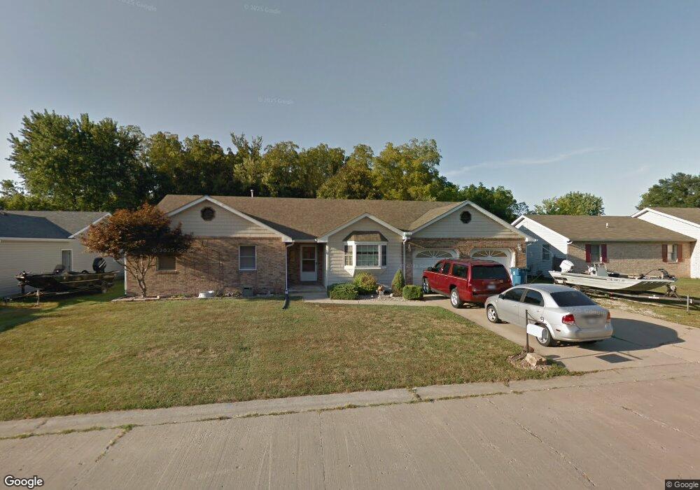
This home is located at 307 Reid Ave, Troy, IL 62294 and is currently estimated at $277,395, approximately $167 per square foot. 307 Reid Ave is a home located in Madison County with nearby schools including Silver Creek Elementary School, Triad Middle School, and Triad High School.
Ownership History
Date
Name
Owned For
Owner Type
Purchase Details
Closed on
Mar 4, 2018
Sold by
Laird Jeffrrey S and Laird Norman L
Bought by
Debourge Kyle S
Current Estimated Value
Home Financials for this Owner
Home Financials are based on the most recent Mortgage that was taken out on this home.
Original Mortgage
$139,428
Outstanding Balance
$121,836
Interest Rate
5.25%
Mortgage Type
FHA
Estimated Equity
$155,559
Create a Home Valuation Report for This Property
The Home Valuation Report is an in-depth analysis detailing your home's value as well as a comparison with similar homes in the area
Home Values in the Area
Average Home Value in this Area
Purchase History
| Date | Buyer | Sale Price | Title Company |
|---|---|---|---|
| Debourge Kyle S | $142,000 | Southern Illinois Real Estat |
Source: Public Records
Mortgage History
| Date | Status | Borrower | Loan Amount |
|---|---|---|---|
| Open | Debourge Kyle S | $139,428 |
Source: Public Records
Tax History
| Year | Tax Paid | Tax Assessment Tax Assessment Total Assessment is a certain percentage of the fair market value that is determined by local assessors to be the total taxable value of land and additions on the property. | Land | Improvement |
|---|---|---|---|---|
| 2024 | $5,344 | $82,490 | $13,660 | $68,830 |
| 2023 | $5,344 | $74,890 | $12,400 | $62,490 |
| 2022 | $4,945 | $68,960 | $11,420 | $57,540 |
| 2021 | $4,575 | $65,540 | $10,850 | $54,690 |
| 2020 | $4,574 | $63,850 | $10,570 | $53,280 |
| 2019 | $4,495 | $62,530 | $10,350 | $52,180 |
| 2018 | $4,375 | $57,930 | $9,590 | $48,340 |
| 2017 | $3,816 | $56,720 | $9,390 | $47,330 |
| 2016 | $3,795 | $56,970 | $9,340 | $47,630 |
| 2015 | $3,388 | $55,080 | $9,030 | $46,050 |
| 2014 | $3,388 | $55,080 | $9,030 | $46,050 |
| 2013 | $3,388 | $55,080 | $9,030 | $46,050 |
Source: Public Records
Map
Nearby Homes
- 618 Meadowlark St
- 516 Nottingham Dr
- 511 Zenk Rd
- 502 Lindenwood Dr
- 500 Lindenwood Dr
- 2281 Staunton Rd
- 2261 Staunton Rd
- 2265 Staunton Rd
- 2289 Staunton Rd
- 2273 Staunton Rd
- 2285 Staunton Rd
- 2277 Staunton Rd
- 313 Old Homestead Dr
- 2335 Staunton Rd
- 406 Lindenwood Dr
- 518 Bargraves Blvd Unit B
- 124 Taylor Lake Dr
- 402 N Powell St
- 332 N Kimberlin St
- 306 Hazel St
- 309 Reid Ave
- 305 Reid Ave
- 601 Wood Thrush St
- 308 Reid Ave
- 303 Reid Ave
- 603 Wood Thrush St
- 537 Mockingbird St
- 310 Reid Ave
- 605 Wood Thrush St
- 301 Reid Ave
- 602 Whip Poor Will St
- 534 Mockingbird St
- 302 Reid Ave
- 533A Mockingbird St
- 533B Wood Thrush St
- 604 Whip Poor Will St
- 600 Wood Thrush St
- 0 Xxx Blue Bird Ln Unit 21037183
- 402 Blue Bird Ln
- 536 Whip Poor Will St
Your Personal Tour Guide
Ask me questions while you tour the home.