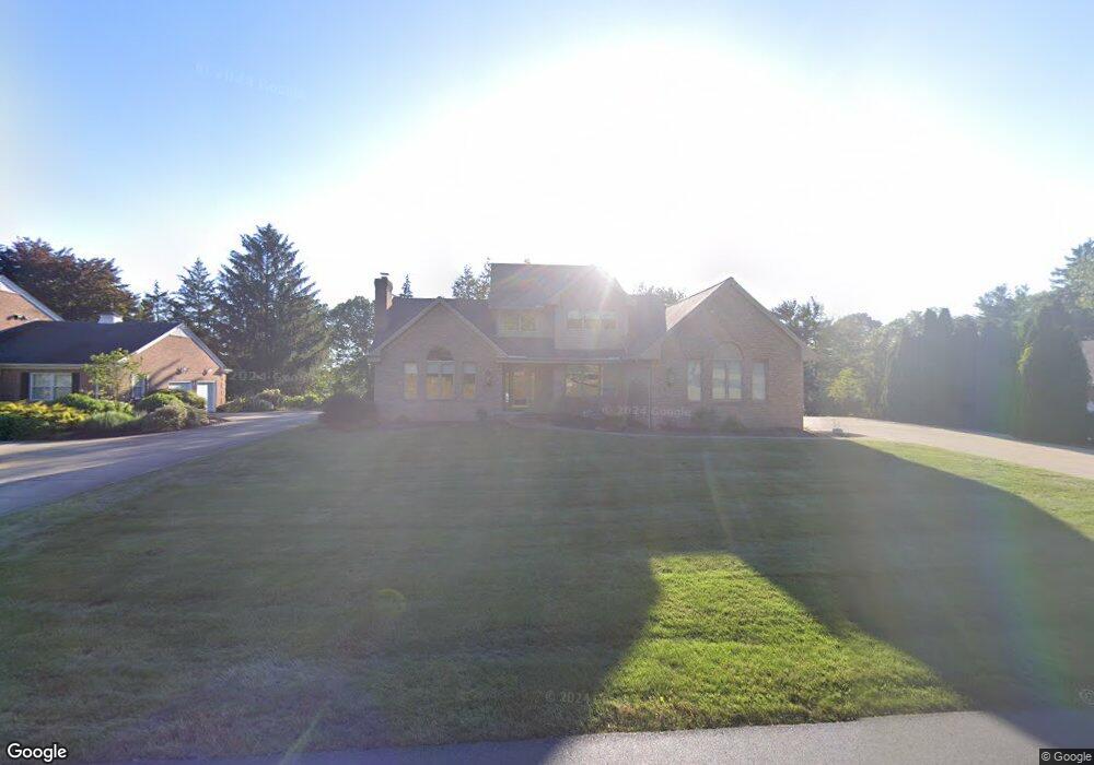
3071 Dunbarton Ave NW Canton, OH 44708
Estimated Value: $520,248 - $606,000
4
Beds
4
Baths
2,909
Sq Ft
$188/Sq Ft
Est. Value
About This Home
This home is located at 3071 Dunbarton Ave NW, Canton, OH 44708 and is currently estimated at $547,562, approximately $188 per square foot. 3071 Dunbarton Ave NW is a home located in Stark County with nearby schools including Lake Cable Elementary School, Jackson Memorial Middle School, and Jackson High School.
Ownership History
Date
Name
Owned For
Owner Type
Purchase Details
Closed on
Feb 23, 2011
Sold by
Coss Harold S and Coss Susan B
Bought by
Coss H Stephen and Coss Susan B
Current Estimated Value
Purchase Details
Closed on
Jul 6, 2006
Sold by
Michael Douglas and Michael Sherri
Bought by
Coss Harold S and Coss Susan B
Home Financials for this Owner
Home Financials are based on the most recent Mortgage that was taken out on this home.
Original Mortgage
$240,000
Interest Rate
6.12%
Mortgage Type
Purchase Money Mortgage
Create a Home Valuation Report for This Property
The Home Valuation Report is an in-depth analysis detailing your home's value as well as a comparison with similar homes in the area
Home Values in the Area
Average Home Value in this Area
Purchase History
| Date | Buyer | Sale Price | Title Company |
|---|---|---|---|
| Coss H Stephen | -- | Attorney | |
| Coss Harold S | $415,000 | Quest Title Agency Inc |
Source: Public Records
Mortgage History
| Date | Status | Borrower | Loan Amount |
|---|---|---|---|
| Closed | Coss Harold S | $240,000 |
Source: Public Records
Tax History Compared to Growth
Tax History
| Year | Tax Paid | Tax Assessment Tax Assessment Total Assessment is a certain percentage of the fair market value that is determined by local assessors to be the total taxable value of land and additions on the property. | Land | Improvement |
|---|---|---|---|---|
| 2025 | -- | $193,350 | $33,850 | $159,500 |
| 2024 | -- | $193,350 | $33,850 | $159,500 |
| 2023 | $7,217 | $145,040 | $28,560 | $116,480 |
| 2022 | $7,179 | $145,040 | $28,560 | $116,480 |
| 2021 | $7,207 | $145,040 | $28,560 | $116,480 |
| 2020 | $6,602 | $122,120 | $24,640 | $97,480 |
| 2019 | $6,359 | $122,120 | $24,640 | $97,480 |
| 2018 | $6,391 | $122,120 | $24,640 | $97,480 |
| 2017 | $6,413 | $116,590 | $18,870 | $97,720 |
| 2016 | $6,456 | $116,590 | $18,870 | $97,720 |
| 2015 | $6,472 | $115,470 | $18,870 | $96,600 |
| 2014 | $298 | $107,460 | $17,540 | $89,920 |
| 2013 | $3,098 | $107,460 | $17,540 | $89,920 |
Source: Public Records
Map
Nearby Homes
- 2421 Brentwood Rd NW
- 5179 Birkdale St NW
- 3273 Dellwood Ave NW
- 0 Dunkeith Dr NW Unit 5083845
- 2742 Dunkeith Dr NW
- 5851 Hawks Nest Cir NW
- 5853 Hawks Nest Cir NW
- 0 Hills And Dales Rd NW Unit 5138797
- 5845 Hawks Nest Cir NW
- 5843 Hawks Nest Cir NW
- 0 Birkdale St NW Unit 5122150
- 5867 Hawks Nest Cir NW
- 5869 Hawks Nest Cir NW
- 5848 Hawks Nest Cir NW
- 5846 Hawks Nest Cir NW
- 5875 Hawks Nest Cir NW
- 5877 Hawks Nest Cir NW
- 5879 Hawks Nest Cir NW
- 5878 Hawks Nest Cir NW Unit 16B
- 5966 Hawks Nest Cir NW
- 3045 Dunbarton Ave NW
- 3091 Dunbarton Ave NW
- 3025 Dunbarton Ave NW
- 3100 Dunbarton Ave NW
- 3003 Dunbarton Ave NW
- 3000 Dunbarton Ave NW
- 2969 Dunbarton Ave NW
- 3125 Dunbarton Ave NW
- 3154 Dunbarton Ave NW
- 5377 Fitzjames Dr NW
- 2949 Dunbarton Ave NW
- 5355 Fitzjames Dr NW
- 3101 Dunbarton Ave NW
- 3161 Dunbarton Ave NW
- 5333 Fitzjames Dr NW
- 2929 Dunbarton Ave NW
- 2910 Dunbarton Ave NW
- Lot #2 Fitzjames Dr NW
- 2405 Brentwood Rd NW
- 2905 Dunbarton Ave NW