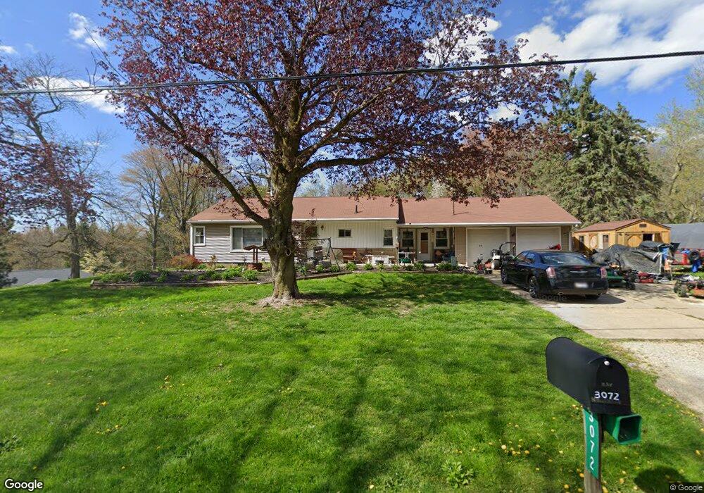
3072 State Route 43 Mogadore, OH 44260
Estimated Value: $227,000 - $288,000
3
Beds
2
Baths
1,360
Sq Ft
$185/Sq Ft
Est. Value
About This Home
This home is located at 3072 State Route 43, Mogadore, OH 44260 and is currently estimated at $252,263, approximately $185 per square foot. 3072 State Route 43 is a home located in Portage County with nearby schools including Suffield Elementary School, Field Middle School, and Field High School.
Ownership History
Date
Name
Owned For
Owner Type
Purchase Details
Closed on
Mar 18, 2015
Sold by
Morehead Kay E
Bought by
Morehead Gilbert L and Morehead Kimberly
Current Estimated Value
Home Financials for this Owner
Home Financials are based on the most recent Mortgage that was taken out on this home.
Original Mortgage
$86,000
Outstanding Balance
$65,574
Interest Rate
3.56%
Mortgage Type
New Conventional
Estimated Equity
$186,689
Purchase Details
Closed on
Aug 20, 1985
Bought by
Morehead Bobby Q
Create a Home Valuation Report for This Property
The Home Valuation Report is an in-depth analysis detailing your home's value as well as a comparison with similar homes in the area
Home Values in the Area
Average Home Value in this Area
Purchase History
| Date | Buyer | Sale Price | Title Company |
|---|---|---|---|
| Morehead Gilbert L | -- | Bennett Land Title Agency | |
| Morehead Bobby Q | $58,000 | -- |
Source: Public Records
Mortgage History
| Date | Status | Borrower | Loan Amount |
|---|---|---|---|
| Open | Morehead Gilbert L | $86,000 |
Source: Public Records
Tax History Compared to Growth
Tax History
| Year | Tax Paid | Tax Assessment Tax Assessment Total Assessment is a certain percentage of the fair market value that is determined by local assessors to be the total taxable value of land and additions on the property. | Land | Improvement |
|---|---|---|---|---|
| 2024 | $3,492 | $73,120 | $12,530 | $60,590 |
| 2023 | $3,417 | $57,610 | $7,840 | $49,770 |
| 2022 | $3,426 | $57,610 | $7,840 | $49,770 |
| 2021 | $3,339 | $57,610 | $7,840 | $49,770 |
| 2020 | $2,889 | $44,980 | $7,840 | $37,140 |
| 2019 | $2,852 | $44,980 | $7,840 | $37,140 |
| 2018 | $2,164 | $40,430 | $7,840 | $32,590 |
| 2017 | $2,164 | $40,430 | $7,840 | $32,590 |
| 2016 | $2,158 | $40,430 | $7,840 | $32,590 |
| 2015 | $2,141 | $40,430 | $7,840 | $32,590 |
| 2014 | $2,103 | $40,430 | $7,840 | $32,590 |
| 2013 | $2,021 | $40,430 | $7,840 | $32,590 |
Source: Public Records
Map
Nearby Homes
- 3241 State Route 43
- 1489 Old Forge Rd
- 3434 Lawndale Dr
- 1330 Highpoint St
- 3517 Jameson Dr
- 1707 Old Forge Rd
- 3658 Elmhurst Ct
- 1418 Arcadia Rd
- 3579 Elmhurst Ct
- 3672 Elmhurst Ct
- 1125 Dussel Rd
- 3362 Sunnybrook Rd
- 2835 Sunnybrook Rd
- 3793 Ranfield Rd
- 1088 Irish Rd
- 3946 Mctaggart Blvd
- 596 Ticknor Rd
- 1811 Randolph Rd
- 3868 Willow Way
- 0 Randolph Rd Unit 5112744
- 3074 Ohio 43
- 3068 State Route 43
- 3074 State Route 43
- 3078 State Route 43
- 3060 State Route 43
- 3066 State Route 43
- 3042 State Route 43
- 3075 State Route 43
- 3087 State Route 43
- 3055 State Route 43
- 3138 State Route 43
- 3134 State Route 43
- 3093 State Route 43
- 3018 State Route 43
- 3031 State Route 43
- 3137 Hollybrook Ln
- 2990 State Route 43
- 1246 Doralee Dr
- 1251 Doralee Dr
- 3143 Hollybrook Ln