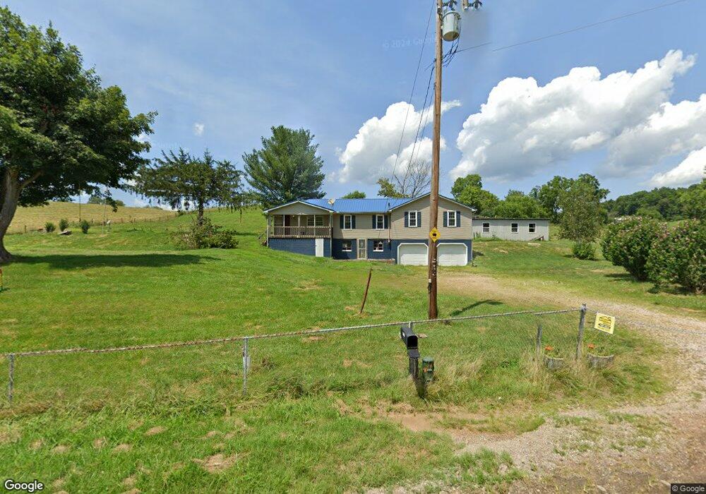
30745 State Route 325 Langsville, OH 45741
Estimated Value: $149,000 - $183,000
--
Bed
2
Baths
1,876
Sq Ft
$87/Sq Ft
Est. Value
About This Home
This home is located at 30745 State Route 325, Langsville, OH 45741 and is currently estimated at $162,542, approximately $86 per square foot. 30745 State Route 325 is a home located in Meigs County with nearby schools including Meigs Primary School, Meigs Intermediate School, and Meigs Middle School.
Ownership History
Date
Name
Owned For
Owner Type
Purchase Details
Closed on
Jun 27, 2025
Sold by
Schoolcraft James H and Schoolcraft Patricia D
Bought by
Hash Dusty R and Hash Molly A
Current Estimated Value
Purchase Details
Closed on
Dec 2, 2005
Sold by
Lambert Shawn E and Lambert Cindy A
Bought by
Schoolcraft James H and Schoolcraft Patricia D
Home Financials for this Owner
Home Financials are based on the most recent Mortgage that was taken out on this home.
Original Mortgage
$60,000
Interest Rate
6.2%
Mortgage Type
Stand Alone First
Purchase Details
Closed on
Jul 22, 1998
Bought by
Schoolcraft Patricia D Schoolcraft
Create a Home Valuation Report for This Property
The Home Valuation Report is an in-depth analysis detailing your home's value as well as a comparison with similar homes in the area
Home Values in the Area
Average Home Value in this Area
Purchase History
| Date | Buyer | Sale Price | Title Company |
|---|---|---|---|
| Hash Dusty R | $150,000 | Bestitle Agency | |
| Schoolcraft James H | -- | Title First Agency Parkersbu | |
| Schoolcraft Patricia D Schoolcraft | $38,000 | -- |
Source: Public Records
Mortgage History
| Date | Status | Borrower | Loan Amount |
|---|---|---|---|
| Previous Owner | Schoolcraft James H | $60,000 |
Source: Public Records
Tax History Compared to Growth
Tax History
| Year | Tax Paid | Tax Assessment Tax Assessment Total Assessment is a certain percentage of the fair market value that is determined by local assessors to be the total taxable value of land and additions on the property. | Land | Improvement |
|---|---|---|---|---|
| 2024 | $1,083 | $43,530 | $9,880 | $33,650 |
| 2023 | $1,083 | $43,530 | $9,880 | $33,650 |
| 2022 | $1,170 | $43,530 | $9,880 | $33,650 |
| 2021 | $890 | $31,110 | $7,250 | $23,860 |
| 2020 | $828 | $31,110 | $7,250 | $23,860 |
| 2019 | $817 | $31,110 | $7,250 | $23,860 |
| 2018 | $588 | $25,030 | $4,240 | $20,790 |
| 2017 | $588 | $25,030 | $4,240 | $20,790 |
| 2016 | $545 | $24,010 | $3,220 | $20,790 |
| 2014 | $490 | $25,380 | $3,220 | $22,160 |
| 2013 | $490 | $25,380 | $3,220 | $22,160 |
Source: Public Records
Map
Nearby Homes
- 0 Briar Ridge Rd Unit 11566708
- 0 Briar Ridge Rd Unit 24580053
- 0 Briar Ridge Rd Unit 24580050
- 32254 Titus Rd
- 32254 Titus Rd Unit (Tract 2 at Titus)
- 30286 Briar Ridge Rd
- 32204 Titus Rd
- 32204 Titus Rd Unit (GV Cabin at Titus)
- 0 Briar Ridge Rd Unit 11562403
- 31428 Will Vance Rd
- 0 Will Vance Rd Unit 23777611
- 33062 Dexter Rd
- 0 Parkinson Rd Unit (Tract 8 at Titus)
- 0 Parkinson Rd Unit 21532380
- 32319 Red Hill Rd Unit (Overlook Cabin at B
- 31845 Red Hill Rd
- 31566 Parker Run Rd
- 0 Red Hill Rd Unit 22347212
- 32325 Red Hill Rd Unit (Phase I Tract 1A Bi
- 31152 Edmundson Rd
- 30777 State Route 325
- 30951 State Route 325
- 30945 State Route 325
- 30969 State Route 325
- 30981 State Route 325
- 30997 State Route 325
- 31003 State Route 325
- 32106 State Route 325
- 32106 State Route 325
- 0 N Side State Rd 325
- 31908 Briar Ridge Rd
- 31894 Briar Ridge Rd
- 31850 Briar Ridge Rd
- 124 Sr
- 31855 Briar Ridge Rd
- 31510 State Route 124
- 31771 State Route 325
- 31423 State Route 124
- 31423 State Route 124
- 31041 State Route 124