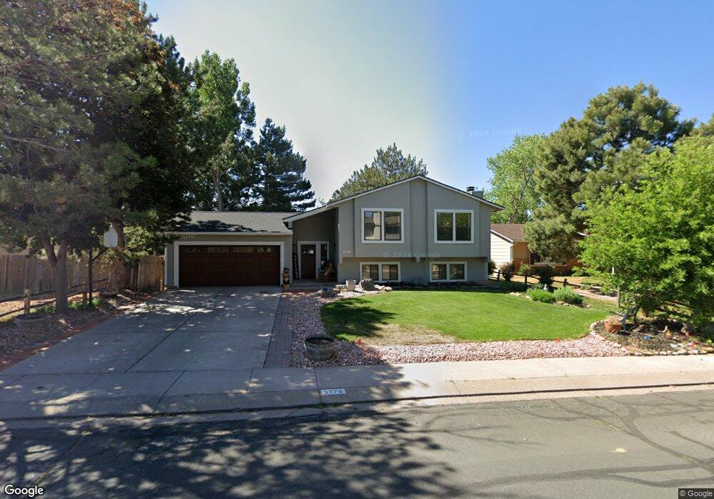
3075 Navigation Dr Colorado Springs, CO 80920
Briargate NeighborhoodEstimated Value: $448,000 - $513,000
5
Beds
3
Baths
1,385
Sq Ft
$343/Sq Ft
Est. Value
About This Home
This home is located at 3075 Navigation Dr, Colorado Springs, CO 80920 and is currently estimated at $474,951, approximately $342 per square foot. 3075 Navigation Dr is a home located in El Paso County with nearby schools including High Plains Elementary School, Mountain Ridge Middle School, and Rampart High School.
Ownership History
Date
Name
Owned For
Owner Type
Purchase Details
Closed on
Jul 3, 2003
Sold by
Vincent Patricia M
Bought by
Romero Mario M and Romero Suzanne M
Current Estimated Value
Home Financials for this Owner
Home Financials are based on the most recent Mortgage that was taken out on this home.
Original Mortgage
$151,336
Outstanding Balance
$64,389
Interest Rate
5.27%
Mortgage Type
FHA
Estimated Equity
$410,562
Purchase Details
Closed on
Nov 30, 1994
Sold by
Vincent James R
Bought by
Vincent Patricia M
Purchase Details
Closed on
Dec 7, 1988
Bought by
Romero Suzanne M
Purchase Details
Closed on
Oct 24, 1988
Bought by
Romero Suzanne M
Purchase Details
Closed on
Jan 1, 1983
Bought by
Romero Suzanne M
Create a Home Valuation Report for This Property
The Home Valuation Report is an in-depth analysis detailing your home's value as well as a comparison with similar homes in the area
Home Values in the Area
Average Home Value in this Area
Purchase History
| Date | Buyer | Sale Price | Title Company |
|---|---|---|---|
| Romero Mario M | $153,500 | Commonwealth Title | |
| Vincent Patricia M | -- | -- | |
| Romero Suzanne M | -- | -- | |
| Romero Suzanne M | -- | -- | |
| Romero Suzanne M | -- | -- |
Source: Public Records
Mortgage History
| Date | Status | Borrower | Loan Amount |
|---|---|---|---|
| Open | Romero Mario M | $151,336 |
Source: Public Records
Tax History Compared to Growth
Tax History
| Year | Tax Paid | Tax Assessment Tax Assessment Total Assessment is a certain percentage of the fair market value that is determined by local assessors to be the total taxable value of land and additions on the property. | Land | Improvement |
|---|---|---|---|---|
| 2025 | $1,988 | $33,610 | -- | -- |
| 2024 | $1,947 | $34,750 | $6,700 | $28,050 |
| 2022 | $1,681 | $23,820 | $5,420 | $18,400 |
| 2021 | $1,751 | $24,500 | $5,580 | $18,920 |
| 2020 | $1,469 | $19,080 | $4,650 | $14,430 |
| 2019 | $1,453 | $19,080 | $4,650 | $14,430 |
| 2018 | $1,146 | $14,780 | $3,600 | $11,180 |
| 2017 | $1,141 | $14,780 | $3,600 | $11,180 |
| 2016 | $1,148 | $14,850 | $3,660 | $11,190 |
| 2015 | $1,146 | $14,850 | $3,660 | $11,190 |
| 2014 | $1,062 | $13,750 | $3,660 | $10,090 |
Source: Public Records
Map
Nearby Homes
- 8213 Caravel Dr
- 3142 Soaring Bird Cir
- 3326 Soaring Bird Cir
- 8112 Old Exchange Dr
- 3690 Amelia Island St
- 2768 Thrush Grove
- 8020 Cooper River Dr
- 3339 Union Jack Way
- 8335 Saint Helena Dr
- 8118 Ravenel Dr
- 2656 Marston Heights
- 7849 Flicker Grove
- 3746 St Simons Ct
- 7870 Chimney Terrace
- 8261 Cooper River Dr
- 2644 Marston Heights
- 2340 Winstead View
- 2615 Thrush Grove
- 2730 Kenton Green Ct
- 3329 Misty Meadows Dr
- 3065 Navigation Dr
- 3085 Navigation Dr
- 8135 Brigantine Dr
- 8129 Brigantine Dr
- 3055 Navigation Dr
- 8150 Helm Ct
- 8215 Cutter Terrace
- 8141 Brigantine Dr
- 8123 Brigantine Dr
- 3080 Navigation Dr
- 8140 Helm Ct
- 3045 Navigation Dr
- 8147 Brigantine Dr
- 8225 Cutter Terrace
- 8117 Brigantine Dr
- 8130 Helm Ct
- 8210 Cutter Terrace
- 3110 Navigation Dr
- 8132 Brigantine Dr
- 3035 Navigation Dr