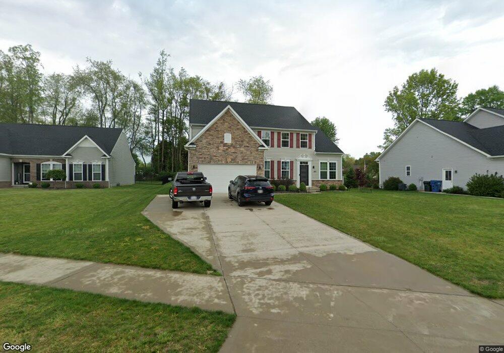
3075 Stonehurst Rd Uniontown, OH 44685
Estimated Value: $497,000 - $563,000
4
Beds
3
Baths
2,514
Sq Ft
$214/Sq Ft
Est. Value
About This Home
This home is located at 3075 Stonehurst Rd, Uniontown, OH 44685 and is currently estimated at $537,231, approximately $213 per square foot. 3075 Stonehurst Rd is a home located in Stark County with nearby schools including Greenwood Elementary School, Green Primary School, and Green Intermediate Elementary School.
Ownership History
Date
Name
Owned For
Owner Type
Purchase Details
Closed on
Aug 25, 2022
Sold by
Limerick Courtney T
Bought by
Mchenry Matthieu and Mchenry Jody
Current Estimated Value
Purchase Details
Closed on
Oct 26, 2018
Sold by
Nvr Inc
Bought by
Limerick Courtney T
Home Financials for this Owner
Home Financials are based on the most recent Mortgage that was taken out on this home.
Original Mortgage
$320,520
Interest Rate
4.7%
Mortgage Type
New Conventional
Purchase Details
Closed on
Apr 12, 2018
Sold by
Lakes Of Green Ltd
Bought by
Nvr Inc and Ryan Homes
Create a Home Valuation Report for This Property
The Home Valuation Report is an in-depth analysis detailing your home's value as well as a comparison with similar homes in the area
Home Values in the Area
Average Home Value in this Area
Purchase History
| Date | Buyer | Sale Price | Title Company |
|---|---|---|---|
| Mchenry Matthieu | $475,000 | Ohio Real Title | |
| Limerick Courtney T | $337,390 | None Available | |
| Nvr Inc | $51,500 | Nvr Title Agency Llc |
Source: Public Records
Mortgage History
| Date | Status | Borrower | Loan Amount |
|---|---|---|---|
| Previous Owner | Limerick Courtney T | $320,520 |
Source: Public Records
Tax History Compared to Growth
Tax History
| Year | Tax Paid | Tax Assessment Tax Assessment Total Assessment is a certain percentage of the fair market value that is determined by local assessors to be the total taxable value of land and additions on the property. | Land | Improvement |
|---|---|---|---|---|
| 2025 | $6,909 | $145,548 | $22,295 | $123,253 |
| 2024 | $6,909 | $145,548 | $22,295 | $123,253 |
| 2023 | $6,909 | $145,548 | $22,295 | $123,253 |
| 2022 | $6,170 | $116,761 | $17,980 | $98,781 |
| 2021 | $5,790 | $116,761 | $17,980 | $98,781 |
| 2020 | $5,677 | $116,760 | $17,980 | $98,780 |
| 2019 | $5,773 | $111,930 | $17,260 | $94,670 |
| 2018 | $115 | $1,010 | $1,010 | $0 |
| 2017 | $0 | $0 | $0 | $0 |
Source: Public Records
Map
Nearby Homes
- 2830 Superior Dr
- 3979 Northdale St NW
- 2771 Superior Dr
- 13704 Greenland Ave NW
- 2944 Sunset Dr
- 3796 Sweitzer St NW
- 3003 Myersville Rd
- 0 Pine St NW
- 2664 Pine Lake Trail
- 2619 Henrietta Dr
- 2577 Sweitzer Rd
- 3212 Deborah Ct
- 3217 Deborah Ct
- 2864 Pine Lake Rd
- 3310 Linden St NW
- 3100 Linden St NW
- 2811 Canton Rd
- 3221 Killian Rd
- 2500 Marlborough Dr
- 2575 Myersville Rd
- 3075 Stonehurst Rd
- 3065 Stonehurst Rd
- 3081 Stonehurst Rd
- 3088 Stonehurst Rd
- 3087 Stonehurst Rd
- 3059 Stonehurst Rd
- 3078 Stonehurst Rd
- 2660 Woodview Rd
- 3058 Stonehurst Rd
- 2731 Watervale Dr
- 3048 Stonehurst Rd
- 3099 Stonehurst Rd
- 3082 Stonehurst Rd
- 3037 Stonehurst Rd
- 3098 Stonehurst Rd
- 2665 Woodview Rd
- 2652 Woodview Rd
- 3272 Pebble Stone Dr
- 3034 Stonehurst Dr
- 3279 Pebble Stone Dr