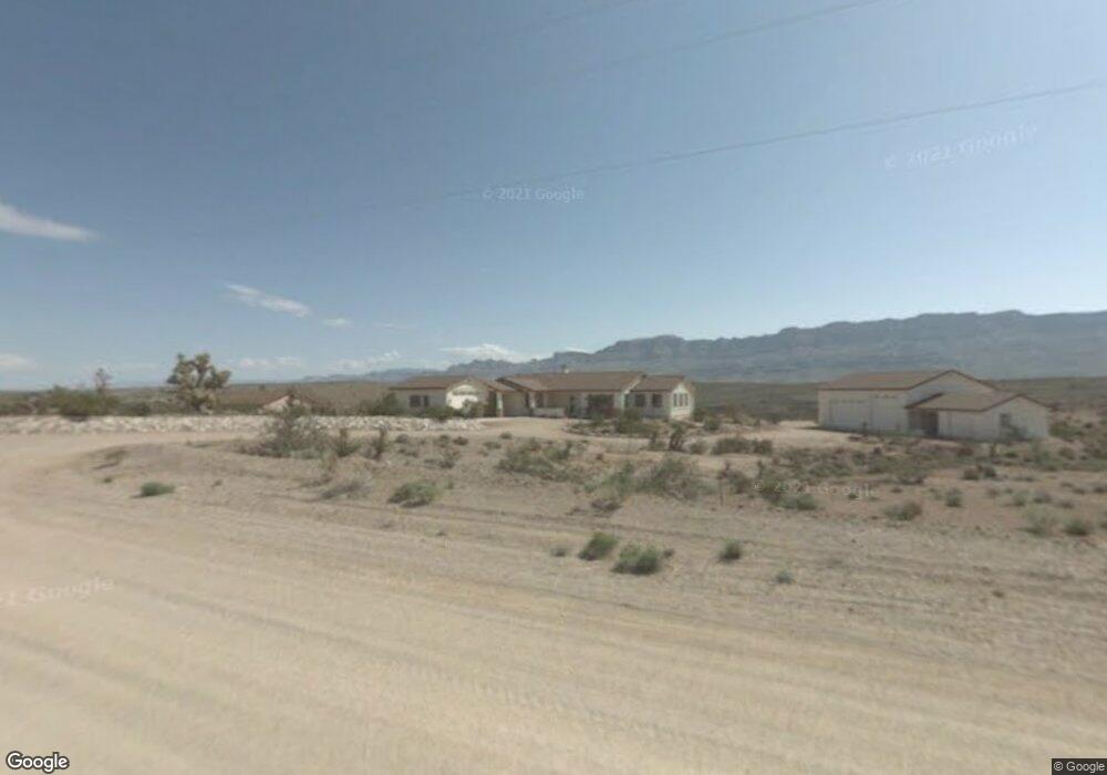
30760 N Spencer Dr Meadview, AZ 86444
Estimated Value: $311,000 - $374,070
--
Bed
1
Bath
2,300
Sq Ft
$152/Sq Ft
Est. Value
About This Home
This home is located at 30760 N Spencer Dr, Meadview, AZ 86444 and is currently estimated at $349,268, approximately $151 per square foot. 30760 N Spencer Dr is a home with nearby schools including Cerbat Elementary School, Kingman Middle School, and Kingman High School.
Ownership History
Date
Name
Owned For
Owner Type
Purchase Details
Closed on
Sep 23, 2025
Sold by
Dear Family Trust and Dear Lorne A
Bought by
Hartwig Family Trust and Hartwig
Current Estimated Value
Purchase Details
Closed on
Feb 25, 2013
Sold by
Dear Lorne A and Dear Terry L
Bought by
Dear Lorne A and Dear Terry L
Purchase Details
Closed on
Dec 5, 2001
Sold by
Mitchell Ivan Lloyd and Mitchell Martha Ruth
Bought by
Dear Lorne A and Dear Terry L
Purchase Details
Closed on
Aug 25, 2000
Sold by
Mitchell Ivan Lloyd and Mitchell Martha Ruth
Bought by
Mitchell Ivan Lloyd and Mitchell Martha Ruth
Create a Home Valuation Report for This Property
The Home Valuation Report is an in-depth analysis detailing your home's value as well as a comparison with similar homes in the area
Home Values in the Area
Average Home Value in this Area
Purchase History
| Date | Buyer | Sale Price | Title Company |
|---|---|---|---|
| Hartwig Family Trust | $383,000 | Premier Title Agency | |
| Dear Lorne A | -- | None Available | |
| Dear Lorne A | $22,500 | Chicago Title Insurance Co | |
| Mitchell Ivan Lloyd | -- | -- |
Source: Public Records
Tax History Compared to Growth
Tax History
| Year | Tax Paid | Tax Assessment Tax Assessment Total Assessment is a certain percentage of the fair market value that is determined by local assessors to be the total taxable value of land and additions on the property. | Land | Improvement |
|---|---|---|---|---|
| 2026 | -- | -- | -- | -- |
| 2025 | $2,302 | $0 | $0 | $0 |
| 2024 | $2,302 | $34,965 | $0 | $0 |
| 2023 | $2,302 | $33,573 | $0 | $0 |
| 2022 | $2,109 | $27,241 | $0 | $0 |
| 2021 | $2,141 | $22,499 | $0 | $0 |
| 2019 | $1,933 | $17,233 | $0 | $0 |
| 2018 | $2,026 | $16,913 | $0 | $0 |
| 2017 | $1,951 | $17,442 | $0 | $0 |
| 2016 | $1,872 | $16,437 | $0 | $0 |
| 2015 | $1,908 | $16,050 | $0 | $0 |
Source: Public Records
Map
Nearby Homes
- 800 N Bright Angel Dr
- 1360 Dellenbaugh Dr
- 1365 Dellenbaugh Dr
- 1305 Dellenbaugh Dr
- 1105 & 1145 E Stanton Dr
- 1005 Supai Dr
- 1360 Diamond Creek Dr
- 1280 Diamond Creek Dr
- 840 Dellenbaugh Dr
- 1210 Hance Dr Unit 158
- 285 Dellenbaugh Dr
- 760 Supai Dr
- 845 E Supai Dr
- 1150 Price Dr
- 790 Yates Dr
- 715 Sumner Dr
- 1205 E Spencer Dr
- 715 Whitmore Dr
- 670 Sumner Dr Unit 154
- 590 Sumner Dr
- 30800 N Spencer Dr
- 30740 N Spencer Dr
- 30820 N Spencer Dr
- 1360 E Spencer Way
- 1320 Spencer Way
- 1320 E Spencer Way
- 1320 E Spencer Way
- 30840 N Spencer Dr
- 825 E Bright Angel Dr
- 1365 Mohawk Dr
- 30730 Spencer Dr
- 795 E Bright Angel Dr Unit 11
- 1200 E Spencer Way
- 1120 E Mohawk Dr
- 775 E Bright Angel Dr
- 775 Bright Angel Dr
- 1320 Mohawk Dr
- 1221 Mohawk Dr
- 765 E Bright Angel Dr
- 765 Bright Angel Dr