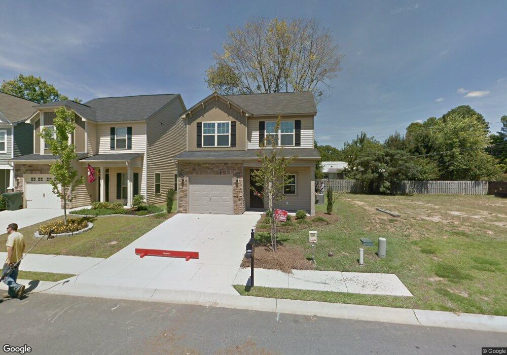
308 Eastfair Dr Columbia, SC 29209
Southeast Columbia NeighborhoodEstimated Value: $243,000 - $264,000
3
Beds
3
Baths
1,733
Sq Ft
$145/Sq Ft
Est. Value
About This Home
This home is located at 308 Eastfair Dr, Columbia, SC 29209 and is currently estimated at $250,713, approximately $144 per square foot. 308 Eastfair Dr is a home located in Richland County with nearby schools including Annie Burnside Elementary School, Crayton Middle School, and A. C. Flora High School.
Ownership History
Date
Name
Owned For
Owner Type
Purchase Details
Closed on
Jun 27, 2018
Sold by
Axelson Dwayne and Axelson Linda Susan Beauregard
Bought by
Walker Angela
Current Estimated Value
Home Financials for this Owner
Home Financials are based on the most recent Mortgage that was taken out on this home.
Original Mortgage
$163,532
Outstanding Balance
$142,868
Interest Rate
4.87%
Mortgage Type
FHA
Estimated Equity
$107,845
Purchase Details
Closed on
Jan 19, 2015
Sold by
Mungo Homes Inc
Bought by
Beauregard Axelson Linda S and Beauregard Axelson
Create a Home Valuation Report for This Property
The Home Valuation Report is an in-depth analysis detailing your home's value as well as a comparison with similar homes in the area
Home Values in the Area
Average Home Value in this Area
Purchase History
| Date | Buyer | Sale Price | Title Company |
|---|---|---|---|
| Walker Angela | $166,550 | None Available | |
| Beauregard Axelson Linda S | $56,903 | -- | |
| Mungo Homes Inc | -- | -- |
Source: Public Records
Mortgage History
| Date | Status | Borrower | Loan Amount |
|---|---|---|---|
| Open | Walker Angela | $163,532 |
Source: Public Records
Tax History Compared to Growth
Tax History
| Year | Tax Paid | Tax Assessment Tax Assessment Total Assessment is a certain percentage of the fair market value that is determined by local assessors to be the total taxable value of land and additions on the property. | Land | Improvement |
|---|---|---|---|---|
| 2024 | $1,321 | $191,600 | $0 | $0 |
| 2023 | $1,321 | $6,664 | $0 | $0 |
| 2022 | $1,207 | $166,600 | $18,500 | $148,100 |
| 2021 | $1,247 | $6,660 | $0 | $0 |
| 2020 | $1,315 | $6,660 | $0 | $0 |
| 2019 | $4,941 | $10,000 | $0 | $0 |
| 2018 | $1,095 | $5,380 | $0 | $0 |
| 2017 | $1,066 | $5,380 | $0 | $0 |
| 2016 | $1,028 | $5,380 | $0 | $0 |
| 2015 | $29 | $150 | $0 | $0 |
| 2014 | $102 | $3,700 | $0 | $0 |
| 2013 | -- | $220 | $0 | $0 |
Source: Public Records
Map
Nearby Homes
- 349 Eastfair Dr
- 1527 Burnside Ave
- 2 Routhland Ct
- 155 Colonial Commons Ln
- 267 Blue Savannah St
- 263 Blue Savannah St
- 168 Ashewood Commons Dr
- 7428 Fairmont Rd
- 7712 Burdell Dr
- 525 Eastfair Dr
- 115 Colonial Commons Ln
- 106 Colonial Commons Ln
- 101 Colonial Commons Ln
- 175 Nestle Ct
- 7637 Shiran St
- 7245 Venus Rd
- 7600 Leitner Rd
- 7229 Holloway Rd
- 7819 Charles Towne Dr
- 7024 Hilo St