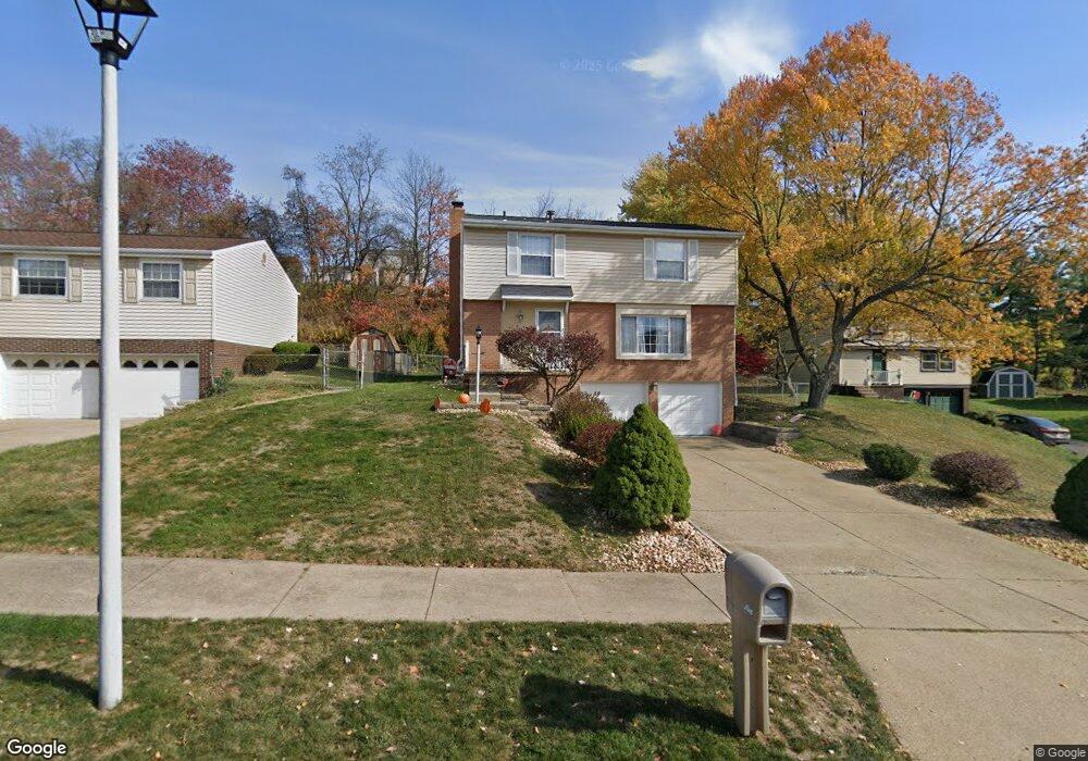
308 Macnab Dr Coraopolis, PA 15108
Estimated Value: $298,000 - $352,000
4
Beds
3
Baths
1,568
Sq Ft
$207/Sq Ft
Est. Value
About This Home
This home is located at 308 Macnab Dr, Coraopolis, PA 15108 and is currently estimated at $324,433, approximately $206 per square foot. 308 Macnab Dr is a home located in Allegheny County with nearby schools including Moon Area High School.
Ownership History
Date
Name
Owned For
Owner Type
Purchase Details
Closed on
Aug 19, 2011
Sold by
Heigley Jason W
Bought by
Deluca Christopher L
Current Estimated Value
Home Financials for this Owner
Home Financials are based on the most recent Mortgage that was taken out on this home.
Original Mortgage
$137,600
Outstanding Balance
$95,494
Interest Rate
4.62%
Mortgage Type
New Conventional
Estimated Equity
$228,939
Purchase Details
Closed on
Nov 15, 2004
Sold by
Hooper Brian M
Bought by
Heigley Jason W
Home Financials for this Owner
Home Financials are based on the most recent Mortgage that was taken out on this home.
Original Mortgage
$124,000
Interest Rate
5.75%
Mortgage Type
New Conventional
Purchase Details
Closed on
Jul 24, 2001
Sold by
Autry Marcia L and Autry Donald A
Bought by
Hooper Brian M and Hooper Melissa L
Create a Home Valuation Report for This Property
The Home Valuation Report is an in-depth analysis detailing your home's value as well as a comparison with similar homes in the area
Home Values in the Area
Average Home Value in this Area
Purchase History
| Date | Buyer | Sale Price | Title Company |
|---|---|---|---|
| Deluca Christopher L | $172,000 | -- | |
| Heigley Jason W | $155,000 | -- | |
| Hooper Brian M | $123,000 | -- |
Source: Public Records
Mortgage History
| Date | Status | Borrower | Loan Amount |
|---|---|---|---|
| Open | Deluca Christopher L | $137,600 | |
| Previous Owner | Heigley Jason W | $124,000 |
Source: Public Records
Tax History Compared to Growth
Tax History
| Year | Tax Paid | Tax Assessment Tax Assessment Total Assessment is a certain percentage of the fair market value that is determined by local assessors to be the total taxable value of land and additions on the property. | Land | Improvement |
|---|---|---|---|---|
| 2025 | $4,332 | $138,600 | $43,400 | $95,200 |
| 2024 | $4,332 | $138,600 | $43,400 | $95,200 |
| 2023 | $4,178 | $138,600 | $43,400 | $95,200 |
| 2022 | $4,178 | $138,600 | $43,400 | $95,200 |
| 2021 | $4,177 | $138,600 | $43,400 | $95,200 |
| 2020 | $4,073 | $138,600 | $43,400 | $95,200 |
| 2019 | $3,962 | $138,600 | $43,400 | $95,200 |
| 2018 | $656 | $138,600 | $43,400 | $95,200 |
| 2017 | $3,746 | $138,600 | $43,400 | $95,200 |
| 2016 | $656 | $138,600 | $43,400 | $95,200 |
| 2015 | $656 | $138,600 | $43,400 | $95,200 |
| 2014 | $3,648 | $138,600 | $43,400 | $95,200 |
Source: Public Records
Map
Nearby Homes
- 174 Cimarron Dr
- 101 Darnley Dr
- 116 Mesa Dr
- 120 Scottsdale Dr
- 347 Ranchero Dr
- 101 Glengarry Dr
- 0 Spring Run Road Extension Unit 1684623
- 603 Meade Dr
- 141 Elmhurst Dr
- 208 Lochinver Dr
- 7011 Weeping Willow Dr
- 001 Spring Run Road Extension
- 1490 Olde Stable Ln
- Eisenhower Plan at Victoria Ridge
- Cleveland Plan at Victoria Ridge
- Birmingham Plan at Victoria Ridge
- Chattanooga Plan at Victoria Ridge
- Rockford Plan at Victoria Ridge
- Truman Plan at Victoria Ridge
- Reagan Plan at Victoria Ridge