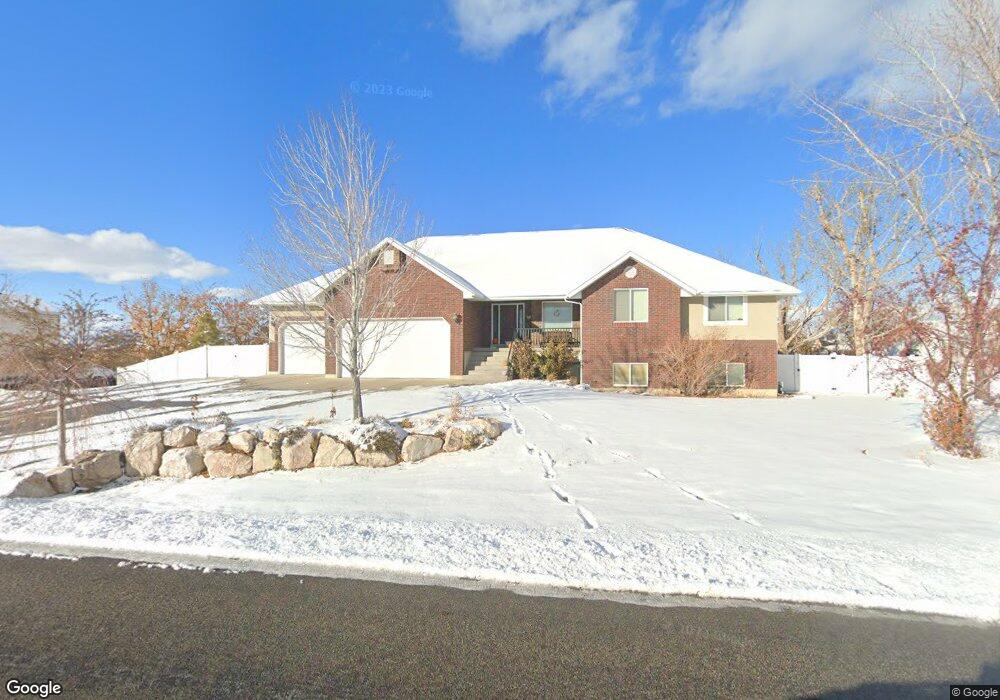
3086 W 2500 N Clinton, UT 84015
Estimated Value: $728,000 - $1,094,117
5
Beds
4
Baths
2,220
Sq Ft
$410/Sq Ft
Est. Value
About This Home
This home is located at 3086 W 2500 N, Clinton, UT 84015 and is currently estimated at $911,029, approximately $410 per square foot. 3086 W 2500 N is a home located in Davis County with nearby schools including West Clinton Elementary School, West Point Junior High School, and Clearfield High School.
Ownership History
Date
Name
Owned For
Owner Type
Purchase Details
Closed on
Jun 21, 2006
Sold by
Ferree Melvin E and Ferree Hui Fen
Bought by
Andreason Guy M and Andreason Becky
Current Estimated Value
Create a Home Valuation Report for This Property
The Home Valuation Report is an in-depth analysis detailing your home's value as well as a comparison with similar homes in the area
Home Values in the Area
Average Home Value in this Area
Purchase History
| Date | Buyer | Sale Price | Title Company |
|---|---|---|---|
| Andreason Guy M | -- | Backman Title Services |
Source: Public Records
Tax History Compared to Growth
Tax History
| Year | Tax Paid | Tax Assessment Tax Assessment Total Assessment is a certain percentage of the fair market value that is determined by local assessors to be the total taxable value of land and additions on the property. | Land | Improvement |
|---|---|---|---|---|
| 2025 | $5,823 | $559,900 | $167,639 | $392,261 |
| 2024 | $4,876 | $535,150 | $173,906 | $361,244 |
| 2023 | $4,876 | $872,000 | $216,318 | $655,682 |
| 2022 | $5,226 | $517,000 | $110,707 | $406,293 |
| 2021 | $4,585 | $673,000 | $176,348 | $496,652 |
| 2020 | $4,103 | $596,000 | $174,126 | $421,874 |
| 2019 | $4,094 | $581,000 | $160,344 | $420,656 |
| 2018 | $3,572 | $498,000 | $130,544 | $367,456 |
| 2016 | $3,578 | $257,566 | $55,169 | $202,397 |
| 2015 | $3,641 | $249,205 | $55,169 | $194,036 |
| 2014 | $3,181 | $221,186 | $55,169 | $166,017 |
| 2013 | -- | $205,043 | $41,313 | $163,730 |
Source: Public Records
Map
Nearby Homes
- 2571 N 3200 W
- 3028 W 2600 N
- 3027 W 2600 N
- 3033 W 2600 N
- 3186 W 2600 N
- 3068 W 2600 N
- 3016 W 2650 N
- 2542 N 3300 W
- 3298 W 2300 N
- 4276 W 6025 S
- 4438 W 6025 S
- 2444 N Stanley Crane Dr
- 462 S 4450 W Unit 504
- 4164 W 5950 S
- 2118 Snowy Crane Dr
- Torino Farmhouse Plan at Cranefield Estates
- 2000 Traditional Plan at Cranefield Estates - Estates Collection
- Murano Traditional Plan at Cranefield Estates - Estates Collection
- 2400 Farmhouse Plan at Cranefield Estates - Estates Collection
- 1825 Traditional Plan at Cranefield Estates - Estates Collection
- 3086 W 2500 N Unit 33
- 3062 W 2500 N
- 3114 W 2500 N
- 3077 W 2500 N
- 2448 N 3125 W
- 3038 W 2500 N
- 3138 W 2500 N
- 3041 W 2500 N
- 3014 W 2500 N Unit 3
- 3014 W 2500 N Unit 30
- 3014 W 2500 N
- 2414 N 3125 W
- 2433 N 3125 W
- 2467 N 3125 W Unit 26
- 2467 N 3125 W
- 2506 N 3200 W
- 2509 N 2950 W Unit 18
- 2531 N 2950 W
- 2392 N 3125 W
- 2974 W 2550 N