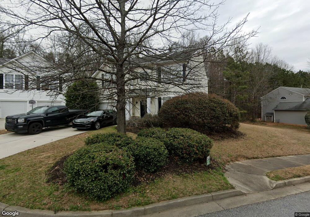
309 Alderman Trace SW Austell, GA 30168
Estimated Value: $249,000 - $353,000
3
Beds
3
Baths
1,900
Sq Ft
$163/Sq Ft
Est. Value
About This Home
This home is located at 309 Alderman Trace SW, Austell, GA 30168 and is currently estimated at $309,588, approximately $162 per square foot. 309 Alderman Trace SW is a home located in Cobb County with nearby schools including City View Elementary, Lindley Middle School, and Pebblebrook High School.
Ownership History
Date
Name
Owned For
Owner Type
Purchase Details
Closed on
Dec 19, 2014
Sold by
Tarbert Llc
Bought by
Sway 2014 1 Borrower Llc
Current Estimated Value
Purchase Details
Closed on
Jan 31, 2014
Sold by
Srp Sub Llc
Bought by
Tarbert Llc and C O Waypoint Homes
Purchase Details
Closed on
Sep 20, 2013
Sold by
Gipson Cedrick
Bought by
Srp Sub Llc
Purchase Details
Closed on
Sep 30, 2011
Sold by
Secretary Of Housing And U
Bought by
Gipson Cedrick
Home Financials for this Owner
Home Financials are based on the most recent Mortgage that was taken out on this home.
Original Mortgage
$59,918
Interest Rate
4.26%
Mortgage Type
New Conventional
Purchase Details
Closed on
Apr 5, 2011
Sold by
Wells Fargo Bk Na
Bought by
Hud-Housing Of Urban Dev
Create a Home Valuation Report for This Property
The Home Valuation Report is an in-depth analysis detailing your home's value as well as a comparison with similar homes in the area
Home Values in the Area
Average Home Value in this Area
Purchase History
| Date | Buyer | Sale Price | Title Company |
|---|---|---|---|
| Sway 2014 1 Borrower Llc | -- | -- | |
| Tarbert Llc | -- | -- | |
| Srp Sub Llc | $112,000 | -- | |
| Gipson Cedrick | $79,891 | -- | |
| Hud-Housing Of Urban Dev | -- | -- | |
| Wells Fargo Bk Na | $156,526 | -- |
Source: Public Records
Mortgage History
| Date | Status | Borrower | Loan Amount |
|---|---|---|---|
| Previous Owner | Gipson Cedrick | $59,918 |
Source: Public Records
Tax History Compared to Growth
Tax History
| Year | Tax Paid | Tax Assessment Tax Assessment Total Assessment is a certain percentage of the fair market value that is determined by local assessors to be the total taxable value of land and additions on the property. | Land | Improvement |
|---|---|---|---|---|
| 2025 | $3,862 | $128,180 | $28,000 | $100,180 |
| 2024 | $3,031 | $100,516 | $16,000 | $84,516 |
| 2023 | $3,031 | $100,516 | $16,000 | $84,516 |
| 2022 | $3,051 | $100,516 | $16,000 | $84,516 |
| 2021 | $2,034 | $67,008 | $10,800 | $56,208 |
| 2020 | $2,034 | $67,008 | $10,800 | $56,208 |
| 2019 | $2,034 | $67,008 | $10,800 | $56,208 |
| 2018 | $1,790 | $58,972 | $10,800 | $48,172 |
| 2017 | $1,695 | $58,972 | $10,800 | $48,172 |
| 2016 | $1,419 | $49,356 | $8,000 | $41,356 |
| 2015 | $1,153 | $39,128 | $7,200 | $31,928 |
| 2014 | $1,162 | $39,128 | $0 | $0 |
Source: Public Records
Map
Nearby Homes
- 338 Alderman Trace
- 201 Wilhelmina Dr
- 6941 Gallant Cir SE Unit 10
- 6947 Gallant Cir SE Unit 10
- 6874 Bridgewood Dr
- 253 Gallant Cir SE Unit 17
- 218 Copperbend Dr
- 6854 Bridgewood Dr
- 7066 Oakhill Cir
- 7010 Oakhill Cir
- 7074 Oakhill Cir
- 7080 Fringe Flower Dr Unit 18
- 7224 Kings Cove Unit 10
- 6730 Gallant Ct SE
- 0 Cityview Dr SW Unit 10597603
- 6726 Gallant Ct SE Unit 30
- 306 Bonnes Dr
- 295 Sweetshrub Dr Unit 2
- 6812 Gallant Cir SE Unit 1
- 6760 Mableton Pkwy SE
- 309 Alderman Trace
- 311 Alderman Trace
- 307 Alderman Trace
- 313 Alderman Trace
- 7213 Silver Mine Pass
- 305 Alderman Trace
- 312 Alderman Trace
- 303 Alderman Trace
- 315 Alderman Trace
- 316 Alderman Trace
- 7212 Silver Mine Pass
- 7215 Silver Mine Pass
- 317 Alderman Trace
- 7214 Silver Mine Pass Unit III
- 320 Alderman Trace
- 7217 Silver Mine Pass
- 301 Alderman Trace
- 306 Alderman Trace
- 7104 Alderman Ridge
- 319 Alderman Trace