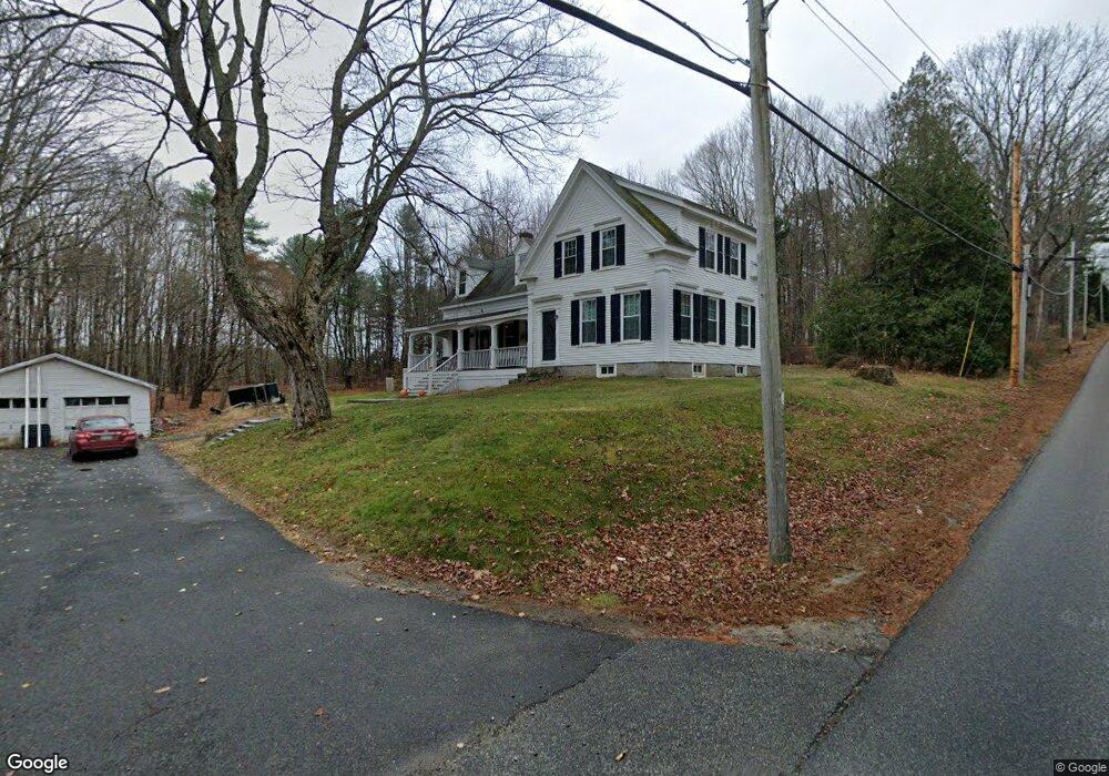
309 N Gorham Rd Gorham, ME 04038
North Gorham NeighborhoodEstimated Value: $386,000 - $564,000
3
Beds
1
Bath
1,969
Sq Ft
$237/Sq Ft
Est. Value
About This Home
This home is located at 309 N Gorham Rd, Gorham, ME 04038 and is currently estimated at $466,496, approximately $236 per square foot. 309 N Gorham Rd is a home located in Cumberland County with nearby schools including Great Falls Elementary School, Gorham Middle School, and Gorham High School.
Ownership History
Date
Name
Owned For
Owner Type
Purchase Details
Closed on
Sep 4, 2009
Sold by
Talmage Kuniko S and Talmage Fred R
Bought by
Verrill Thomas A and Verrill Angela A
Current Estimated Value
Home Financials for this Owner
Home Financials are based on the most recent Mortgage that was taken out on this home.
Original Mortgage
$150,000
Outstanding Balance
$96,190
Interest Rate
5.21%
Mortgage Type
Unknown
Estimated Equity
$370,306
Create a Home Valuation Report for This Property
The Home Valuation Report is an in-depth analysis detailing your home's value as well as a comparison with similar homes in the area
Home Values in the Area
Average Home Value in this Area
Purchase History
| Date | Buyer | Sale Price | Title Company |
|---|---|---|---|
| Verrill Thomas A | -- | -- |
Source: Public Records
Mortgage History
| Date | Status | Borrower | Loan Amount |
|---|---|---|---|
| Open | Verrill Thomas A | $150,000 |
Source: Public Records
Tax History
| Year | Tax Paid | Tax Assessment Tax Assessment Total Assessment is a certain percentage of the fair market value that is determined by local assessors to be the total taxable value of land and additions on the property. | Land | Improvement |
|---|---|---|---|---|
| 2025 | $4,810 | $325,000 | $97,900 | $227,100 |
| 2024 | $4,778 | $325,000 | $97,900 | $227,100 |
| 2023 | $4,461 | $324,400 | $97,900 | $226,500 |
| 2022 | $4,169 | $324,400 | $97,900 | $226,500 |
| 2021 | $3,345 | $172,400 | $73,500 | $98,900 |
| 2020 | $3,276 | $172,400 | $73,500 | $98,900 |
| 2019 | $3,267 | $172,400 | $73,500 | $98,900 |
| 2018 | $3,138 | $172,400 | $73,500 | $98,900 |
| 2017 | $3,136 | $183,400 | $73,500 | $109,900 |
| 2016 | $3,120 | $183,500 | $73,600 | $109,900 |
| 2015 | $2,991 | $183,500 | $73,600 | $109,900 |
| 2014 | $3,094 | $177,800 | $78,300 | $99,500 |
| 2013 | $3,076 | $177,800 | $78,300 | $99,500 |
Source: Public Records
Map
Nearby Homes
- 302 N Gorham Rd
- 3 Rainbow Ln
- 313 N Gorham Rd
- 299 N Gorham Rd
- 312 N Gorham Rd
- 300 N Gorham Rd
- 318 N Gorham Rd
- 3 Standish Neck Rd
- 293 N Gorham Rd
- 317 N Gorham Rd
- 322 N Gorham Rd
- Lot A Rainbow Ln
- lot B Rainbow Ln
- 10 Rainbow Ln
- 0 Standish Neck
- 0 Standish Neck Rd
- 7 Standish Neck Rd
- 8 Middle Jam Rd
- 7 Rainbow Ln
Your Personal Tour Guide
Ask me questions while you tour the home.