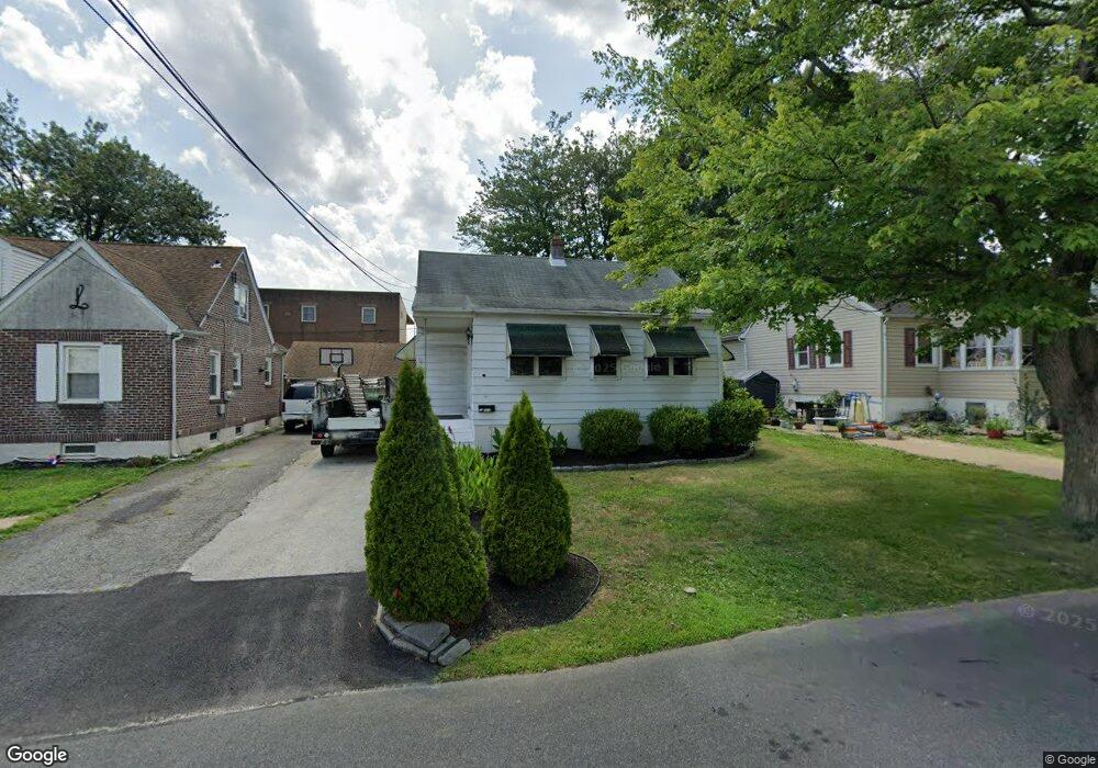
309 Springfield Ave Folsom, PA 19033
Estimated Value: $273,000 - $361,000
2
Beds
1
Bath
960
Sq Ft
$313/Sq Ft
Est. Value
About This Home
This home is located at 309 Springfield Ave, Folsom, PA 19033 and is currently estimated at $300,369, approximately $312 per square foot. 309 Springfield Ave is a home located in Delaware County with nearby schools including Edgewood Elementary School, Ridley Middle School, and Ridley High School.
Ownership History
Date
Name
Owned For
Owner Type
Purchase Details
Closed on
Aug 8, 2024
Sold by
Cannon Diana L and Cannon Robert L
Bought by
Diana Cannon And Robert Cannon Family Trust and Shanshan
Current Estimated Value
Purchase Details
Closed on
Nov 8, 2006
Sold by
Cannon Court Apt Inc
Bought by
Cannon Robert L and Cannon Diana L
Purchase Details
Closed on
Sep 2, 2000
Sold by
Taylor Rita I
Bought by
Cannon Court Apt Inc
Create a Home Valuation Report for This Property
The Home Valuation Report is an in-depth analysis detailing your home's value as well as a comparison with similar homes in the area
Home Values in the Area
Average Home Value in this Area
Purchase History
| Date | Buyer | Sale Price | Title Company |
|---|---|---|---|
| Diana Cannon And Robert Cannon Family Trust | -- | None Listed On Document | |
| Cannon Robert L | -- | None Available | |
| Cannon Court Apt Inc | $90,000 | -- |
Source: Public Records
Tax History Compared to Growth
Tax History
| Year | Tax Paid | Tax Assessment Tax Assessment Total Assessment is a certain percentage of the fair market value that is determined by local assessors to be the total taxable value of land and additions on the property. | Land | Improvement |
|---|---|---|---|---|
| 2025 | $5,393 | $155,320 | $55,680 | $99,640 |
| 2024 | $5,393 | $155,320 | $55,680 | $99,640 |
| 2023 | $5,158 | $155,320 | $55,680 | $99,640 |
| 2022 | $4,993 | $155,320 | $55,680 | $99,640 |
| 2021 | $7,729 | $155,320 | $55,680 | $99,640 |
| 2020 | $5,267 | $93,230 | $33,420 | $59,810 |
| 2019 | $5,170 | $93,230 | $33,420 | $59,810 |
| 2018 | $5,106 | $93,230 | $0 | $0 |
| 2017 | $5,106 | $93,230 | $0 | $0 |
| 2016 | $512 | $93,230 | $0 | $0 |
| 2015 | $522 | $93,230 | $0 | $0 |
| 2014 | $512 | $93,230 | $0 | $0 |
Source: Public Records
Map
Nearby Homes
- 225 Swarthmore Ave
- 222 Ridley Ave
- 121 Swarthmore Ave
- 339 Sutton Ave
- 1828 5th Ave
- 110 Lakeview Dr
- 1618 Pennsylvania Ave
- 740 16th Ave
- 411 Buse St
- 813 14th Ave
- 505 Fernwood Ave
- 209 Amosland Rd
- 510 Amosland Rd
- 1226 Madison Ave
- 219 Willowbrook Ave
- 822 13th Ave
- 516 Edgewood Ave
- 424 Broomall St
- 216-218 President Ave
- 412 Gorsuch St
- 305 Springfield Ave
- 313 Springfield Ave
- 310 Rutledge Ave Unit 5
- 300 Rutledge Ave Unit 11
- 300 Rutledge Ave
- 300 Rutledge Ave Unit 7
- 319 Springfield Ave
- 316 Rutledge Ave
- 314 Springfield Ave
- 310 Springfield Ave
- 321 Springfield Ave
- 320 Rutledge Ave
- 312 Springfield Ave
- 318 Springfield Ave
- 1406 Macdade Blvd
- 325 Springfield Ave
- 238 Rutledge Ave
- 322 Springfield Ave
- 324 Rutledge Ave
- 1404 Macdade Blvd