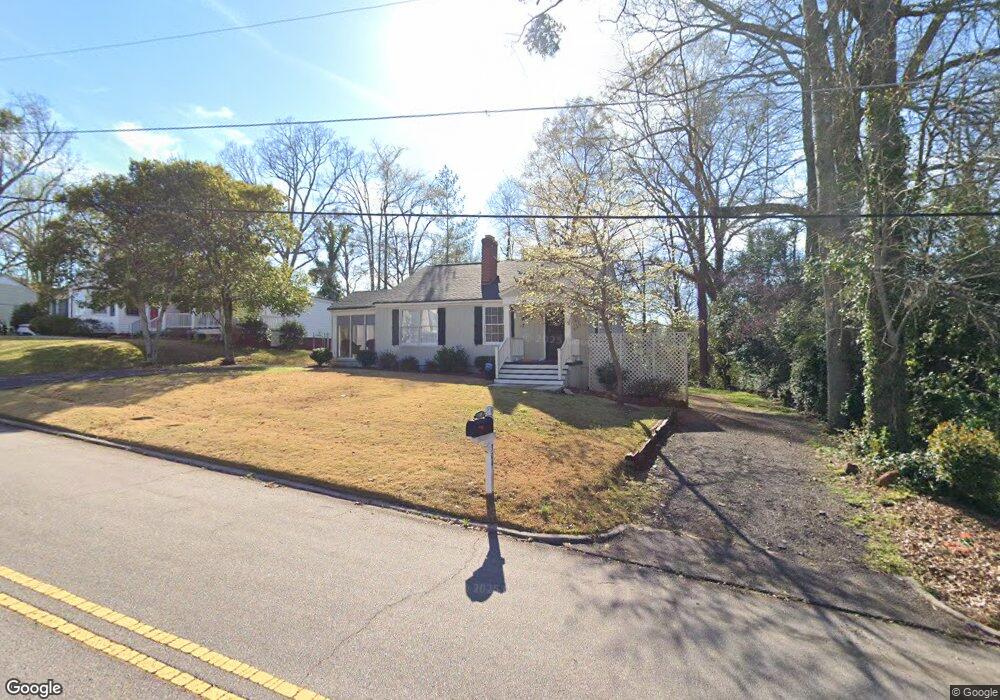
309 W Mclendon Cir Lagrange, GA 30240
Estimated Value: $205,963 - $248,000
3
Beds
2
Baths
1,356
Sq Ft
$169/Sq Ft
Est. Value
About This Home
This home is located at 309 W Mclendon Cir, Lagrange, GA 30240 and is currently estimated at $229,241, approximately $169 per square foot. 309 W Mclendon Cir is a home located in Troup County with nearby schools including Hollis Hand Elementary School, Ethel W. Kight Elementary School, and Franklin Forest Elementary School.
Ownership History
Date
Name
Owned For
Owner Type
Purchase Details
Closed on
Jul 28, 1992
Sold by
Smith David G and Smith Katherine L
Bought by
Livingston Joe H
Current Estimated Value
Purchase Details
Closed on
May 15, 1981
Sold by
Louise R Gallant
Bought by
Smith David G and Smith Katherine L
Purchase Details
Closed on
Jul 22, 1977
Sold by
Gallant James G
Bought by
Louise R Gallant
Purchase Details
Closed on
Jul 1, 1964
Sold by
Rambin William M
Bought by
Gallant James G
Create a Home Valuation Report for This Property
The Home Valuation Report is an in-depth analysis detailing your home's value as well as a comparison with similar homes in the area
Home Values in the Area
Average Home Value in this Area
Purchase History
| Date | Buyer | Sale Price | Title Company |
|---|---|---|---|
| Livingston Joe H | $47,000 | -- | |
| Smith David G | $24,000 | -- | |
| Louise R Gallant | -- | -- | |
| Gallant James G | -- | -- |
Source: Public Records
Tax History Compared to Growth
Tax History
| Year | Tax Paid | Tax Assessment Tax Assessment Total Assessment is a certain percentage of the fair market value that is determined by local assessors to be the total taxable value of land and additions on the property. | Land | Improvement |
|---|---|---|---|---|
| 2024 | $1,901 | $77,520 | $18,000 | $59,520 |
| 2023 | $1,519 | $55,680 | $18,000 | $37,680 |
| 2022 | $1,393 | $49,920 | $14,000 | $35,920 |
| 2021 | $1,222 | $40,520 | $14,000 | $26,520 |
| 2020 | $1,222 | $40,520 | $14,000 | $26,520 |
| 2019 | $1,141 | $37,840 | $14,000 | $23,840 |
| 2018 | $1,141 | $37,840 | $14,000 | $23,840 |
| 2017 | $1,104 | $36,600 | $18,000 | $18,600 |
| 2016 | $1,097 | $36,368 | $18,000 | $18,368 |
| 2015 | $1,099 | $36,368 | $18,000 | $18,368 |
| 2014 | $1,089 | $35,989 | $18,000 | $17,989 |
| 2013 | -- | $26,206 | $7,920 | $18,286 |
Source: Public Records
Map
Nearby Homes
- 105 Saynor Cir
- 203 Waverly Way
- 408 Gordon St
- 110 Waverly Way
- 109 Waverly Way
- 206 Broad St
- 209 Boulevard
- 208 Boulevard
- 609 Cherokee Rd
- 705 Piney Woods Dr
- 609 Ridley Ave
- 707 Ridley Ave
- 611 Ridley Ave
- 615 Ridley Ave
- 709 Ridley Ave
- 0 Ridley Ave Unit 10550104
- 500 Boulevard
- 513 Park Ave
- 505 S Lewis St
- 217 Jefferson St
- 307 W Mclendon Cir
- 311 W Mclendon Cir
- 300 Springdale Dr
- W W Mclendon Cir
- 315 W Mclendon Cir
- 303 W Mclendon Cir
- 304 Springdale Dr
- 208 Springdale Dr
- 204 Ben Hill St
- 306 Springdale Dr
- 319 W Mclendon Cir
- 301 W Mclendon Cir
- 308 Springdale Dr
- 204 Springdale Dr
- 301 Springdale Dr Unit Lot 4
- E E Mclendon Cir
- 203 Ben Hill St
- 323 W Mclendon Cir
- 400 Springdale Dr
- 602 W Haralson St