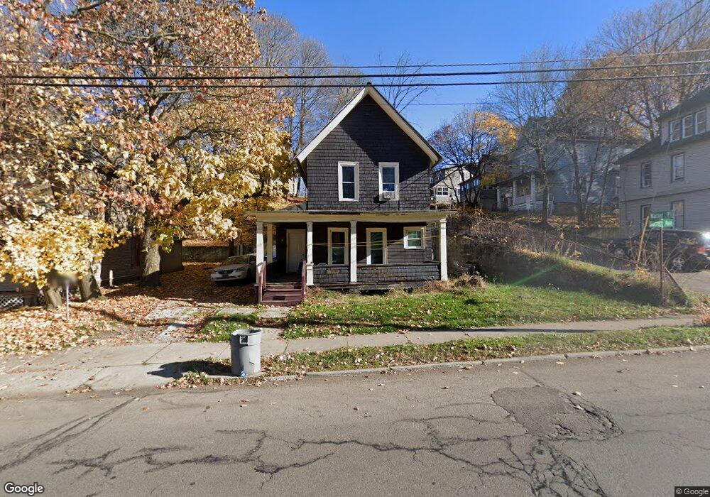
31 Barrett Ave Jamestown, NY 14701
Estimated Value: $57,000 - $72,000
4
Beds
2
Baths
1,924
Sq Ft
$32/Sq Ft
Est. Value
About This Home
This home is located at 31 Barrett Ave, Jamestown, NY 14701 and is currently estimated at $61,872, approximately $32 per square foot. 31 Barrett Ave is a home located in Chautauqua County with nearby schools including Jamestown High School, Catholic Academy of The Holy Family, and Jamestown SDA School.
Ownership History
Date
Name
Owned For
Owner Type
Purchase Details
Closed on
Feb 28, 2022
Sold by
Kimberly Miller
Bought by
Mk River Holdings Llc
Current Estimated Value
Purchase Details
Closed on
Jul 20, 2011
Sold by
County Of Chautauqua
Bought by
Miller Kimberly
Purchase Details
Closed on
Mar 22, 2006
Sold by
Welsh Richard H
Bought by
Jonnett Developments Pty Ltd
Purchase Details
Closed on
Jul 18, 2005
Sold by
Lake Shore Savings And Lo An Assoc
Bought by
Welsh Richard H
Purchase Details
Closed on
Mar 4, 2005
Sold by
Himes Paul
Bought by
Lakeshore Savings & Loan Ass
Create a Home Valuation Report for This Property
The Home Valuation Report is an in-depth analysis detailing your home's value as well as a comparison with similar homes in the area
Home Values in the Area
Average Home Value in this Area
Purchase History
| Date | Buyer | Sale Price | Title Company |
|---|---|---|---|
| Mk River Holdings Llc | -- | Wright Calimeri Pllc | |
| Miller Kimberly | $500 | Law Department | |
| County Of Chautauqua | $5,638 | Law Department | |
| Jonnett Developments Pty Ltd | $6,000 | John Vanstrom | |
| Welsh Richard H | $6,500 | Randy E Rhinehart | |
| Lakeshore Savings & Loan Ass | $22,026 | David Foley |
Source: Public Records
Tax History Compared to Growth
Tax History
| Year | Tax Paid | Tax Assessment Tax Assessment Total Assessment is a certain percentage of the fair market value that is determined by local assessors to be the total taxable value of land and additions on the property. | Land | Improvement |
|---|---|---|---|---|
| 2024 | $1,351 | $26,000 | $2,100 | $23,900 |
| 2023 | $1,356 | $26,000 | $2,100 | $23,900 |
| 2022 | $1,442 | $26,000 | $2,100 | $23,900 |
| 2021 | $1,445 | $26,000 | $2,100 | $23,900 |
| 2020 | $1,351 | $26,000 | $2,100 | $23,900 |
| 2019 | $838 | $26,000 | $2,100 | $23,900 |
| 2018 | $1,343 | $26,000 | $2,100 | $23,900 |
| 2017 | $1,351 | $26,000 | $2,100 | $23,900 |
| 2016 | $1,348 | $26,000 | $2,100 | $23,900 |
| 2015 | -- | $26,000 | $2,100 | $23,900 |
| 2014 | -- | $26,000 | $2,100 | $23,900 |
Source: Public Records
Map
Nearby Homes
- 27 Barrett Ave
- 33 Barrett Ave
- 23 Barrett Ave
- 26 Warner Place
- 35 Warner Place
- 0 Baker St Ext &Trask Rd Unit 1041911
- 0 Baker St Ext &Trask Rd-Lot #2
- 0 Baker St Ext &Trask Rd-Lot #4
- 0 Baker St Ext &Trask Rd
- 0 Baker Street Ext & Trask Rd
- 0 Baker Street Ext & Trask Rd Unit 1027597
- 0 Baker Street Ext & Trask Rd Unit B388349
- 0 Baker St Ext &Trask Rd Unit 1040076
- 0 Baker St Ext &Trask Rd-Lot #1 Unit 1041913
- 0 Baker St Ext &Trask Rd-Lot #4 Unit 1041912
- 0 Baker St Ext &Trask Rd-Lot #2 Unit 1041910
- 31 Warner Place
- 21 Barrett Ave
- 35 Barrett Ave
- 9 Forest Park