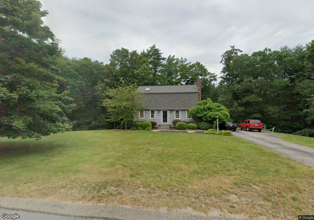
31 Bavarian Way Kingston, MA 02364
Estimated Value: $666,562 - $742,000
3
Beds
2
Baths
1,778
Sq Ft
$395/Sq Ft
Est. Value
About This Home
This home is located at 31 Bavarian Way, Kingston, MA 02364 and is currently estimated at $703,141, approximately $395 per square foot. 31 Bavarian Way is a home located in Plymouth County with nearby schools including Kingston Elementary School, Silver Lake Regional High School, and Kingston Intermediate School.
Ownership History
Date
Name
Owned For
Owner Type
Purchase Details
Closed on
Jul 26, 2011
Sold by
Shea Michael B
Bought by
Shea Cheryl A
Current Estimated Value
Purchase Details
Closed on
Apr 26, 1996
Sold by
Carolyn D Johnson T
Bought by
White Scott A and White Kathleen A
Purchase Details
Closed on
Jun 16, 1995
Sold by
Brown Peter D and Brown Michelle A
Bought by
Shea Michael B and Shea Cheryl A
Create a Home Valuation Report for This Property
The Home Valuation Report is an in-depth analysis detailing your home's value as well as a comparison with similar homes in the area
Home Values in the Area
Average Home Value in this Area
Purchase History
| Date | Buyer | Sale Price | Title Company |
|---|---|---|---|
| Shea Cheryl A | -- | -- | |
| White Scott A | $160,000 | -- | |
| Shea Michael B | $155,000 | -- |
Source: Public Records
Mortgage History
| Date | Status | Borrower | Loan Amount |
|---|---|---|---|
| Previous Owner | Shea Michael B | $187,000 | |
| Previous Owner | Shea Michael B | $40,000 | |
| Previous Owner | Shea Michael B | $30,000 | |
| Previous Owner | Shea Michael B | $140,000 |
Source: Public Records
Tax History Compared to Growth
Tax History
| Year | Tax Paid | Tax Assessment Tax Assessment Total Assessment is a certain percentage of the fair market value that is determined by local assessors to be the total taxable value of land and additions on the property. | Land | Improvement |
|---|---|---|---|---|
| 2025 | $7,255 | $559,400 | $217,700 | $341,700 |
| 2024 | $6,623 | $521,100 | $189,300 | $331,800 |
| 2023 | $6,362 | $476,200 | $189,300 | $286,900 |
| 2022 | $6,366 | $436,600 | $172,100 | $264,500 |
| 2021 | $9,906 | $391,000 | $172,100 | $218,900 |
| 2020 | $6,173 | $379,200 | $172,100 | $207,100 |
| 2019 | $5,968 | $362,600 | $172,100 | $190,500 |
| 2018 | $10,105 | $336,500 | $172,100 | $164,400 |
| 2017 | $5,470 | $331,500 | $164,600 | $166,900 |
| 2016 | $5,112 | $290,300 | $143,100 | $147,200 |
| 2015 | $4,875 | $287,800 | $143,100 | $144,700 |
| 2014 | $4,760 | $285,400 | $143,100 | $142,300 |
Source: Public Records
Map
Nearby Homes
- 0 Spring St
- 6 Twin Pines Ln Unit 6
- 6 Kestrel Way
- 48 Columbia Cir
- 122 High St
- 34 Surrey Dr
- 20 Spring St
- 3 Alec Ln
- 64 Wenham Rd
- 200 Plympton Rd
- 51 Mariner's Way Unit 51
- 37 Flintlocke Dr
- 19 Coachman Terrace
- 28 Fawn Dr
- 2 Mariner's Way Unit 306
- 17 Lydia Dr
- 6 Stone Gate Dr
- 18 Lombard St
- 6 Deer Hill Ln
- 6 Susan Cir