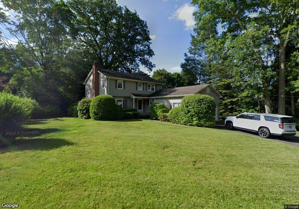
31 Brandywine Rd Stamford, CT 06905
Turn of the River-Newfield NeighborhoodEstimated Value: $1,034,000 - $1,150,000
4
Beds
3
Baths
3,216
Sq Ft
$338/Sq Ft
Est. Value
About This Home
This home is located at 31 Brandywine Rd, Stamford, CT 06905 and is currently estimated at $1,088,573, approximately $338 per square foot. 31 Brandywine Rd is a home located in Fairfield County with nearby schools including Davenport Ridge Elementary School, Rippowam Middle School, and Stamford High School.
Ownership History
Date
Name
Owned For
Owner Type
Purchase Details
Closed on
Dec 28, 2006
Sold by
Duer David A and Duer Rae A
Bought by
Oloughlin Andrea and Oloughlin Brian
Current Estimated Value
Purchase Details
Closed on
Nov 10, 2004
Sold by
Ossewaarde Jon and Ossewaarde Nancy A
Bought by
Duer David A and Duer Rae P
Purchase Details
Closed on
May 6, 1998
Sold by
Annetta Patrick
Bought by
Ossewarde John B and Ossewarde Nancy A
Purchase Details
Closed on
Jul 23, 1993
Sold by
Glatzhofer Edwin and Glatzhofer B
Bought by
Annetta Patrick
Create a Home Valuation Report for This Property
The Home Valuation Report is an in-depth analysis detailing your home's value as well as a comparison with similar homes in the area
Home Values in the Area
Average Home Value in this Area
Purchase History
| Date | Buyer | Sale Price | Title Company |
|---|---|---|---|
| Oloughlin Andrea | $748,000 | -- | |
| Oloughlin Andrea | $748,000 | -- | |
| Duer David A | $690,000 | -- | |
| Duer David A | $690,000 | -- | |
| Ossewarde John B | $352,000 | -- | |
| Ossewarde John B | $352,000 | -- | |
| Annetta Patrick | $314,000 | -- | |
| Annetta Patrick | $314,000 | -- |
Source: Public Records
Mortgage History
| Date | Status | Borrower | Loan Amount |
|---|---|---|---|
| Open | Annetta Patrick | $560,000 | |
| Closed | Annetta Patrick | $570,000 |
Source: Public Records
Tax History Compared to Growth
Tax History
| Year | Tax Paid | Tax Assessment Tax Assessment Total Assessment is a certain percentage of the fair market value that is determined by local assessors to be the total taxable value of land and additions on the property. | Land | Improvement |
|---|---|---|---|---|
| 2025 | $13,160 | $556,220 | $285,950 | $270,270 |
| 2024 | $12,871 | $556,220 | $285,950 | $270,270 |
| 2023 | $13,828 | $556,220 | $285,950 | $270,270 |
| 2022 | $12,172 | $455,210 | $222,470 | $232,740 |
| 2021 | $12,040 | $455,210 | $222,470 | $232,740 |
| 2020 | $11,731 | $455,210 | $222,470 | $232,740 |
| 2019 | $11,731 | $455,210 | $222,470 | $232,740 |
| 2018 | $11,298 | $455,210 | $222,470 | $232,740 |
| 2017 | $10,571 | $406,570 | $207,100 | $199,470 |
| 2016 | $10,274 | $406,570 | $207,100 | $199,470 |
| 2015 | $10,006 | $406,570 | $207,100 | $199,470 |
| 2014 | $9,672 | $406,570 | $207,100 | $199,470 |
Source: Public Records
Map
Nearby Homes
- 14 Barmore Dr
- 7 the Reserve at Sterling Ridge
- 34 Bradley Place
- 56 Bradley Place
- 393 Upper Haig Ave
- 27 Emma Rd
- 38 Lancaster Place
- 21 Nichols Ave
- 31 Gray Farms Rd
- 83 Mulberry St
- 44 Brundage St
- 1148 Hope St
- 1157 Hope St
- 119 Wedgemere Rd
- 113 Wood Ridge Dr
- 77 Putter Dr
- 22 Hastings Ln
- 6 Walnut Ridge Ct
- 433 High Ridge Rd
- 12 Walnut Ridge Ct