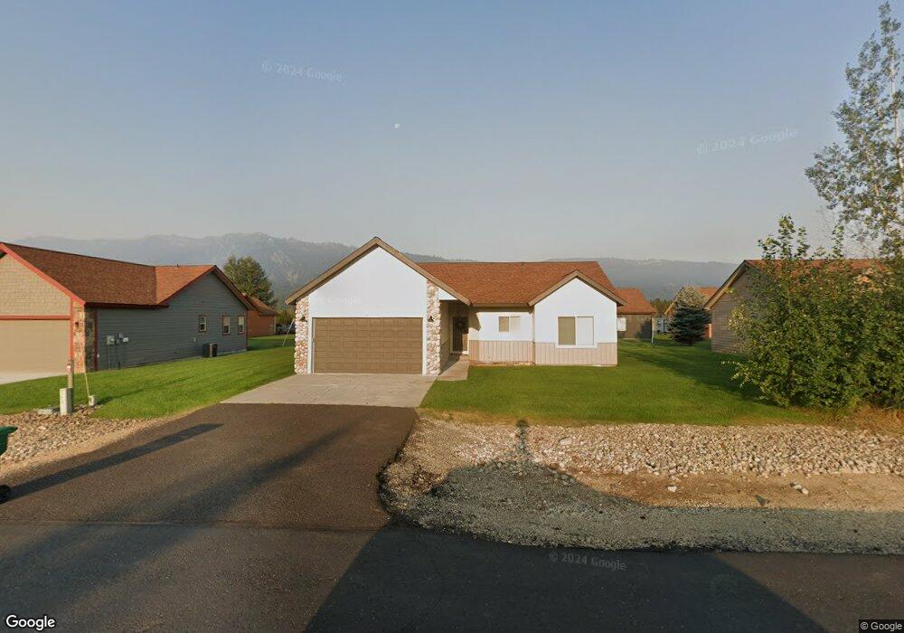
31 Buckskin Rd Donnelly, ID 83615
Estimated Value: $405,000 - $435,000
3
Beds
1
Bath
1,322
Sq Ft
$315/Sq Ft
Est. Value
About This Home
This home is located at 31 Buckskin Rd, Donnelly, ID 83615 and is currently estimated at $416,911, approximately $315 per square foot. 31 Buckskin Rd is a home located in Valley County with nearby schools including Donnelly Elementary School and McCall-Donnelly High School.
Ownership History
Date
Name
Owned For
Owner Type
Purchase Details
Closed on
May 13, 2019
Sold by
Lancaster Anthony E and Lancaster Roxanne
Bought by
Thompson Tiffanie and Bernt Treg A
Current Estimated Value
Home Financials for this Owner
Home Financials are based on the most recent Mortgage that was taken out on this home.
Original Mortgage
$151,920
Outstanding Balance
$133,297
Interest Rate
4.1%
Mortgage Type
New Conventional
Estimated Equity
$283,614
Purchase Details
Closed on
Dec 9, 2014
Sold by
Lancaster Anthony E and Lancaster Anthony
Bought by
Lancaster Anthony E and Lancaster Roxanne
Purchase Details
Closed on
Aug 23, 2006
Sold by
Timberline Development Llc
Bought by
Keyser David S and Keyser Anita L
Home Financials for this Owner
Home Financials are based on the most recent Mortgage that was taken out on this home.
Original Mortgage
$156,112
Interest Rate
6.53%
Mortgage Type
New Conventional
Create a Home Valuation Report for This Property
The Home Valuation Report is an in-depth analysis detailing your home's value as well as a comparison with similar homes in the area
Home Values in the Area
Average Home Value in this Area
Purchase History
| Date | Buyer | Sale Price | Title Company |
|---|---|---|---|
| Thompson Tiffanie | -- | First American Title Mccall | |
| Lancaster Anthony E | -- | Pioneer Title Canyon | |
| Keyser David S | -- | -- |
Source: Public Records
Mortgage History
| Date | Status | Borrower | Loan Amount |
|---|---|---|---|
| Open | Thompson Tiffanie | $151,920 | |
| Previous Owner | Keyser David S | $156,112 |
Source: Public Records
Tax History Compared to Growth
Tax History
| Year | Tax Paid | Tax Assessment Tax Assessment Total Assessment is a certain percentage of the fair market value that is determined by local assessors to be the total taxable value of land and additions on the property. | Land | Improvement |
|---|---|---|---|---|
| 2025 | $1,103 | $391,576 | $26,590 | $364,986 |
| 2023 | $1,103 | $447,412 | $27,434 | $419,978 |
| 2022 | $1,226 | $399,929 | $27,434 | $372,495 |
| 2021 | $1,119 | $232,661 | $21,103 | $211,558 |
| 2020 | $1,082 | $187,751 | $26,187 | $161,564 |
| 2019 | $923 | $146,156 | $24,940 | $121,216 |
| 2018 | $897 | $134,371 | $23,379 | $110,992 |
| 2017 | $973 | $133,645 | $26,771 | $106,874 |
| 2016 | $907 | $122,300 | $25,000 | $97,300 |
| 2015 | $801 | $101,695 | $0 | $0 |
| 2013 | -- | $99,035 | $0 | $0 |
Source: Public Records
Map
Nearby Homes
- 13111 Cameron Dr
- 22 Charters Dr
- 16 Buckskin Dr
- 24 Mangum Cir Unit 1
- 20 #5 W Mangum Cir Unit 5
- 24 Mangum Dr Unit # 1 Unit 1
- Lot 4 Hideout Dr Unit 4
- 20 Mangum Cir Unit 8
- Lot 6 Hideout Dr Unit 6
- 35 1 Mangum Cir
- 35 Mangum Cir Unit 1
- 32 Mangum Cir Unit 3
- 32 Mangum Cir
- 13098 Hill House Loop
- 34 Mangum Cir Unit 8
- 13091 Hill House Loop
- 13078 Hill House Loop
- 13076 Hill House Loop
- 1816 Schultz
- 1816 Schultz Unit 15
- 31 Buckskin Dr
- 29 Buckskin Rd
- 29 Buckskin Dr
- 33 Buckskin Rd
- 33 Buckskin Dr
- 49 Buckskin Dr
- 49 Buckskin Dr
- 32 Timberline Dr
- 30 Timberline Dr
- 34 Timberline Dr
- 28 Timberline Dr
- 27 Buckskin Dr
- 35 Buckskin Rd
- 35 Buckskin Dr
- 28 Buckskin Rd
- 28 Buckskin Dr
- 26 Timberline Dr
- 15 Price St Unit 2
- 25 Buckskin Rd
- 37 Buckskin Dr