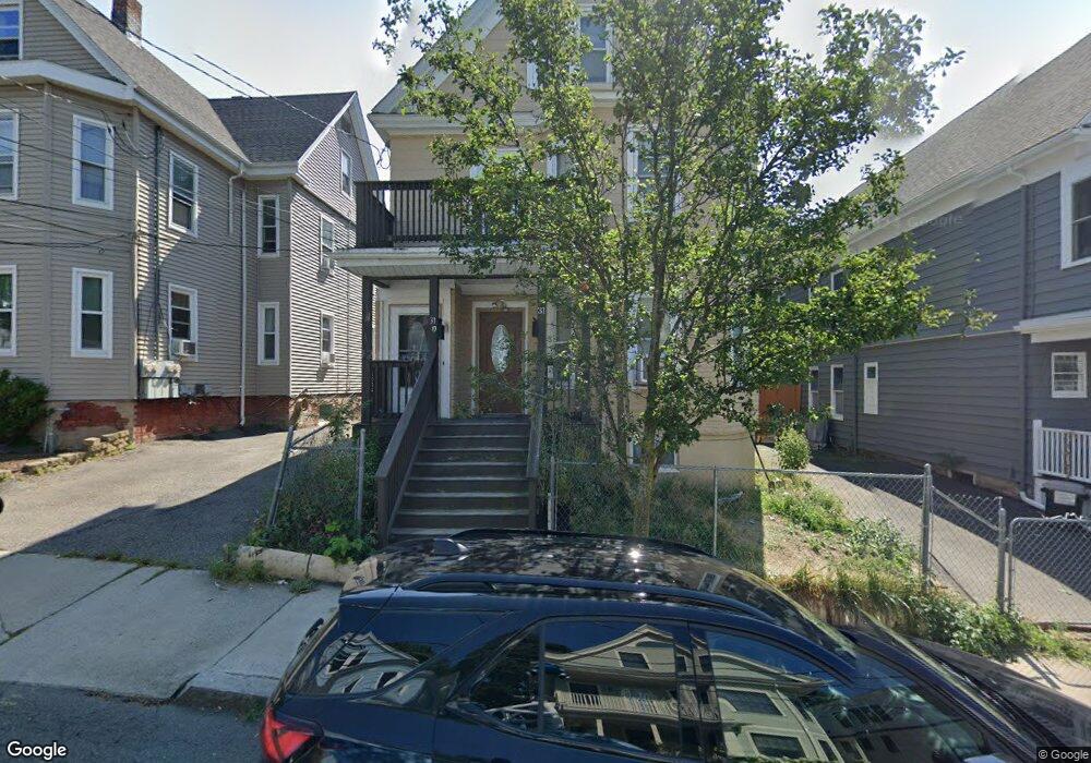
31 Burnside Ave Somerville, MA 02144
Porter Square NeighborhoodEstimated Value: $1,235,000 - $1,575,284
5
Beds
3
Baths
2,641
Sq Ft
$532/Sq Ft
Est. Value
About This Home
This home is located at 31 Burnside Ave, Somerville, MA 02144 and is currently estimated at $1,405,071, approximately $532 per square foot. 31 Burnside Ave is a home located in Middlesex County with nearby schools including Somerville High School, Benjamin Banneker Charter Public School, and Saint Theresa School.
Ownership History
Date
Name
Owned For
Owner Type
Purchase Details
Closed on
Jul 28, 2025
Sold by
Burnside Edgehill Ret and Edgehill
Bought by
Ronald J Edgehillret J and Ronald Edgehill
Current Estimated Value
Purchase Details
Closed on
Jul 31, 2017
Sold by
Edgehill Walter
Bought by
Burnside Edgehill Ret
Create a Home Valuation Report for This Property
The Home Valuation Report is an in-depth analysis detailing your home's value as well as a comparison with similar homes in the area
Home Values in the Area
Average Home Value in this Area
Purchase History
| Date | Buyer | Sale Price | Title Company |
|---|---|---|---|
| Ronald J Edgehillret J | -- | -- | |
| Ronald J Edgehillret J | -- | -- | |
| Burnside Edgehill Ret | -- | -- | |
| Burnside Edgehill Ret | -- | -- |
Source: Public Records
Tax History
| Year | Tax Paid | Tax Assessment Tax Assessment Total Assessment is a certain percentage of the fair market value that is determined by local assessors to be the total taxable value of land and additions on the property. | Land | Improvement |
|---|---|---|---|---|
| 2025 | $13,833 | $1,267,900 | $809,600 | $458,300 |
| 2024 | $13,062 | $1,241,600 | $809,600 | $432,000 |
| 2023 | $12,757 | $1,233,800 | $809,600 | $424,200 |
| 2022 | $11,938 | $1,172,700 | $771,000 | $401,700 |
| 2021 | $11,586 | $1,137,000 | $765,400 | $371,600 |
| 2020 | $10,754 | $1,065,800 | $714,800 | $351,000 |
| 2019 | $10,975 | $1,020,000 | $697,200 | $322,800 |
| 2018 | $10,259 | $907,100 | $633,800 | $273,300 |
| 2017 | $10,832 | $928,200 | $597,900 | $330,300 |
| 2016 | $9,485 | $757,000 | $445,000 | $312,000 |
| 2015 | $9,017 | $715,100 | $411,000 | $304,100 |
Source: Public Records
Map
Nearby Homes
- 32-40 White St
- 10 Beech St Unit 4
- 10 Beech St Unit 1
- 10 Beech St Unit 3
- 49 Cherry St Unit 1
- 7 Beech St Unit 319
- 7 Beech St Unit 317
- 79 Willow Ave
- 353 Summer St Unit 310
- 355 Highland Ave Unit 3
- 20 Mossland St
- 371 Highland Ave
- 18 Upland Rd Unit 1
- 7 Russell St Unit 1
- 3 Arlington St Unit 44
- 167 Albion St
- 46 Mount Vernon St Unit 1
- 156 Albion St Unit 1
- 16 Rogers Ave
- 68 Winslow Ave
- 29 Burnside Ave
- 35 Burnside Ave
- 25 Burnside Ave
- 37 Burnside Ave Unit 3
- 30 Hancock St
- 30 Hancock St
- 30 Hancock St Unit 1
- 36 Hancock St
- 36 Hancock St Unit 1T
- 36 Hancock St Unit 3
- 39 Burnside Ave Unit 3
- 39 Burnside Ave Unit 2
- 39 Burnside Ave
- 38A Hancock St Unit 3
- 38 Hancock St
- 38 Hancock St Unit 1
- 28 Hancock St
- 30 Burnside Ave Unit 30
- 32 Burnside Ave Unit 1
- 34 Burnside Ave Unit 2
Your Personal Tour Guide
Ask me questions while you tour the home.