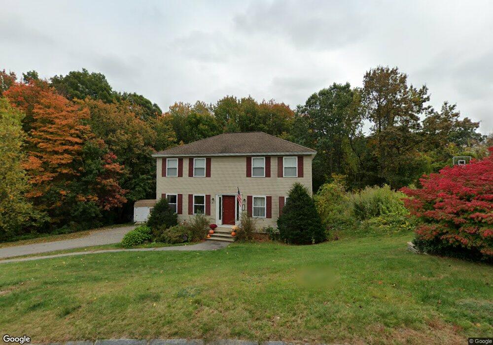
31 Clementi Ln Methuen, MA 01844
The East End NeighborhoodEstimated Value: $677,026 - $779,000
3
Beds
3
Baths
2,340
Sq Ft
$309/Sq Ft
Est. Value
About This Home
This home is located at 31 Clementi Ln, Methuen, MA 01844 and is currently estimated at $722,257, approximately $308 per square foot. 31 Clementi Ln is a home located in Essex County with nearby schools including Methuen High School, Community Day Charter Public School - Gateway, and Esperanza Academy School of Hope.
Ownership History
Date
Name
Owned For
Owner Type
Purchase Details
Closed on
May 27, 2011
Sold by
Moszka Julia T and Moszka Stephen J
Bought by
Mccarthy Robert P and Leblanc Aimee B
Current Estimated Value
Home Financials for this Owner
Home Financials are based on the most recent Mortgage that was taken out on this home.
Original Mortgage
$294,500
Outstanding Balance
$204,503
Interest Rate
4.94%
Mortgage Type
Purchase Money Mortgage
Estimated Equity
$517,754
Purchase Details
Closed on
Apr 13, 1994
Sold by
Saba Glenn G
Bought by
Turner Julia
Create a Home Valuation Report for This Property
The Home Valuation Report is an in-depth analysis detailing your home's value as well as a comparison with similar homes in the area
Home Values in the Area
Average Home Value in this Area
Purchase History
| Date | Buyer | Sale Price | Title Company |
|---|---|---|---|
| Mccarthy Robert P | $310,000 | -- | |
| Mccarthy Robert P | $310,000 | -- | |
| Mccarthy Robert P | $310,000 | -- | |
| Turner Julia | $154,900 | -- | |
| Turner Julia | $154,900 | -- |
Source: Public Records
Mortgage History
| Date | Status | Borrower | Loan Amount |
|---|---|---|---|
| Open | Mccarthy Robert P | $294,500 | |
| Closed | Turner Julia | $294,500 | |
| Previous Owner | Turner Julia | $1,520,000 |
Source: Public Records
Tax History
| Year | Tax Paid | Tax Assessment Tax Assessment Total Assessment is a certain percentage of the fair market value that is determined by local assessors to be the total taxable value of land and additions on the property. | Land | Improvement |
|---|---|---|---|---|
| 2025 | $6,530 | $617,200 | $214,200 | $403,000 |
| 2024 | $6,448 | $593,700 | $188,100 | $405,600 |
| 2023 | $6,144 | $525,100 | $166,400 | $358,700 |
| 2022 | $5,336 | $408,900 | $144,700 | $264,200 |
| 2021 | $5,016 | $380,300 | $137,500 | $242,800 |
| 2020 | $4,967 | $369,600 | $137,500 | $232,100 |
| 2019 | $4,884 | $344,200 | $130,200 | $214,000 |
| 2018 | $4,652 | $326,000 | $123,000 | $203,000 |
| 2017 | $4,506 | $307,600 | $123,000 | $184,600 |
| 2016 | $4,502 | $304,000 | $123,000 | $181,000 |
| 2015 | $4,225 | $289,400 | $115,800 | $173,600 |
Source: Public Records
Map
Nearby Homes
- 16 Christopher Dr Unit 38
- 45 Christopher Dr Unit 106
- 17 Ferry Rd
- 24 Farrwood Place
- 29 Bradstreet Ave
- 6 Ferry Rd
- 183 Farrwood Dr
- 51 Ford St Unit A
- 10 Fenwick Cir
- 414 Farrwood Dr Unit 414
- 5 Pilgrim Cir Unit C
- 27 Russell Farm Dr
- 30 Anderson Dr
- 201 Aberdeen Rd
- 260 Willow Ave
- 524 Merrimack St
- 1 Riverview Blvd Unit 8-203
- 1 Riverview Blvd Unit 1:209
- 1 Riverview Blvd Unit 4-203
- 128 Pleasant Valley St
Your Personal Tour Guide
Ask me questions while you tour the home.